Property Record
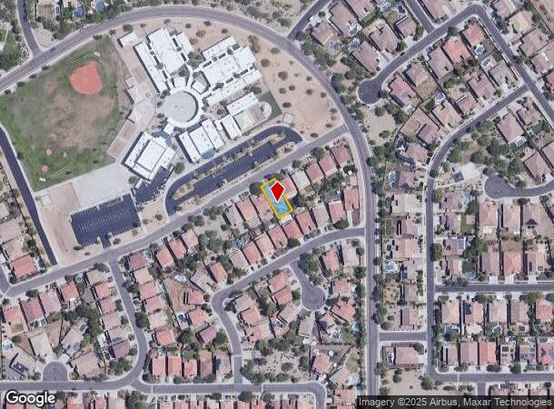
2123 W Maya Way, Phoenix, AZ 85085
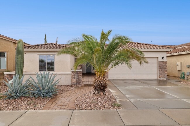
This Property Is For Sale
NEARBY LISTINGS FOR SALE OR LEASE
-
-
View all Phoenix listings for sale on LoopNet.com
Property Detail
2123 W Maya Way
Phoenix-Mesa-Chandler, AZ
Valley Vista Parcel A Amd
210-19-720
VALLEY VISTA PARCEL A AMD MCR 759-49
Sfr
Maricopa
X
Arizona
04013C1280M
298
2025
0.16 AC
2025
North I-17
612302
Phoenix
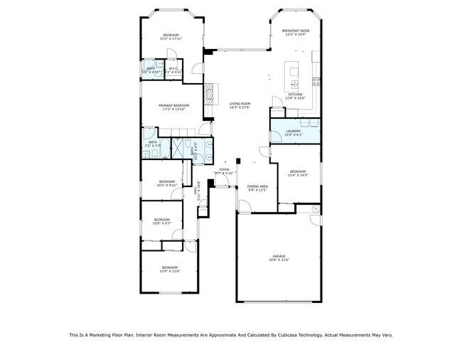
2,318 SF
DEMOGRAPHICS near 2123 W Maya Way
1 mile
3 mile
5 mile
2024 Total Population
9,451
34,038
106,884
2029 Population
9,964
35,830
111,143
Pop Growth 2024-2029
+ 5.43%
+ 5.26%
+ 3.98%
Average Age
36
37
38
2024 Total Households
3,330
12,392
40,712
HH Growth 2024-2029
+ 5.80%
+ 5.46%
+ 4.14%
Median Household Inc
$122,296
$115,111
$104,483
Avg Household Size
2.80
2.70
2.60
2024 Avg HH Vehicles
2.00
2.00
2.00
Median Home Value
$636,058
$573,358
$500,921
Median Year Built
2007
2006
2000
Nearby Places
Map Layers
Map Styles
 Street
 Aerial
Transit
 Traffic
 Biking
Places
Listings with unknown addresses are not visible on the map
- Restaurants
- Banks
- Shops
- Fitness
- Groceries
PUBLIC TRANSPORTATION
AIRPORT
Phoenix Sky Harbor International
Drive
Walk
Distance
Phoenix Sky Harbor International
37 min
27.9 mi
Nearby Properties
Address
Land Use
TOTAL SIZE
Lot Size
Zoning
Address
Land Use
TOTAL SIZE
Lot Size
Zoning
132,348 SF
9.16 AC
I-P
Address
Land Use
TOTAL SIZE
Lot Size
Zoning
2,354,235 SF
83.18 AC
CPGCP
Address
Land Use
TOTAL SIZE
Lot Size
Zoning
267,397 SF
108.70 AC
R-43AG
Address
Land Use
TOTAL SIZE
Lot Size
Zoning
302,786 SF
220.27 AC
S-1
Address
Land Use
TOTAL SIZE
Lot Size
Zoning
355,901 SF
40.61 AC
Address
Land Use
TOTAL SIZE
Lot Size
Zoning
471,671 SF
18.04 AC
I-1
Address
Land Use
TOTAL SIZE
Lot Size
Zoning
425,279 SF
11.64 AC
S1
Address
Land Use
TOTAL SIZE
Lot Size
Zoning
408,519 SF
18.70 AC
PAD
Address
Land Use
TOTAL SIZE
Lot Size
Zoning
388,712 SF
23.13 AC
C2
Address
Land Use
TOTAL SIZE
Lot Size
Zoning
264,522 SF
40 AC
S1
Address
Land Use
TOTAL SIZE
Lot Size
Zoning
307,891 SF
15.89 AC
Address
Land Use
TOTAL SIZE
Lot Size
Zoning
312,070 SF
20.04 AC
A1
Address
Land Use
TOTAL SIZE
Lot Size
Zoning
149,165 SF
12.33 AC
C2
Address
Land Use
TOTAL SIZE
Lot Size
Zoning
266,319 SF
10.28 AC
R3A
Address
Land Use
TOTAL SIZE
Lot Size
Zoning
244,787 SF
5.83 AC
Address
Land Use
TOTAL SIZE
Lot Size
Zoning
15,000 SF
359.72 AC
R-43
Address
Land Use
TOTAL SIZE
Lot Size
Zoning
181,170 SF
7.09 AC
I-P
Address
Land Use
TOTAL SIZE
Lot Size
Zoning
196,485 SF
8.98 AC
Address
Land Use
TOTAL SIZE
Lot Size
Zoning
333,263 SF
12.68 AC
R-43AG
Address
Land Use
TOTAL SIZE
Lot Size
Zoning
199,442 SF
19.27 AC
R3
Address
Land Use
TOTAL SIZE
Lot Size
Zoning
232,395 SF
17.14 AC
CPGCP
Address
Land Use
TOTAL SIZE
Lot Size
Zoning
217,379 SF
16.13 AC
I-1
Address
Land Use
TOTAL SIZE
Lot Size
Zoning
301,696 SF
21.14 AC
I-1
Address
Land Use
TOTAL SIZE
Lot Size
Zoning
135,370 SF
7.18 AC
I-1
Address
Land Use
TOTAL SIZE
Lot Size
Zoning
131,074 SF
7.32 AC
I-1
Address
Land Use
TOTAL SIZE
Lot Size
Zoning
150,102 SF
10.30 AC
C2
Address
Land Use
TOTAL SIZE
Lot Size
Zoning
145,485 SF
34.32 AC
Address
Land Use
TOTAL SIZE
Lot Size
Zoning
98,628 SF
8.55 AC
R-43AG
Address
Land Use
TOTAL SIZE
Lot Size
Zoning
233,949 SF
8.87 AC
M-H
Address
Land Use
TOTAL SIZE
Lot Size
Zoning
363,914 SF
15.10 AC
M-H
The World's #1 Commercial Real Estate Marketplace
Connect with us
© 2026 CoStar Group
The information above has been obtained from sources believed reliable. While we do not doubt its accuracy we have not verified it and make no guarantee, warranty or representation about it. It is your responsibility to independently confirm its accuracy and completeness. Any projections, opinions, assumptions, or estimates used are for example only and do not represent the current or future performance of the property. The value of this transaction to you depends on tax and other factors which should be evaluated by your tax, financial, and legal advisors. You and your advisors should conduct a careful, independent investigation of the property to determine to your satisfaction the suitability of the property for your needs.