Property Record
Sherwood Rd, Belleville, MI 48111
NEARBY LISTINGS FOR SALE OR LEASE
-
-
View all Belleville listings for sale on LoopNet.com
Property Detail
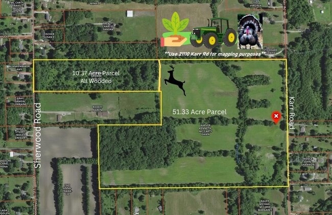
Sherwood Rd
Detroit-Warren-Dearborn, MI
08T1 PT SW 1/4 SEC 8 T4S R8E BEG S0DEG 49M W 669.66FT FROM W 1/4 COR OF SEC 8 TH S0D 49M W 337.67FT TH S88D 57M 55SEC E 1332.68FT TH N0D 25M 54SEC E 340.65FT TH N89D 05M 35SEC W 1330.38FT POB 10.37 AC
81-031-99-0004-000
Wayne
Residentialacreage
Michigan
X
0004
26161C0445E
10.11 AC
2024
Airport District
2025
Detroit
587000
DEMOGRAPHICS near Sherwood Rd
1 Mile
3 Mile
5 Mile
2024 Total Population
1,468
11,351
38,216
2029 Population
1,520
11,213
37,408
Pop Growth 2024-2029
+ 3.54%
(1.22%)
(2.11%)
Average Age
43
42
41
2024 Total Households
581
4,350
15,348
HH Growth 2024-2029
+ 3.61%
(1.15%)
(2.16%)
Median Household Inc
$56,423
$65,516
$69,688
Avg Household Size
2.50
2.60
2.50
2024 Avg HH Vehicles
2.00
2.00
2.00
Median Home Value
$204,571
$226,422
$238,817
Median Year Built
1980
1982
1984
Nearby Places
Map Layers
Map Styles
 Street
 Aerial
- Restaurants
- Banks
- Shops
- Fitness
- Groceries
PUBLIC TRANSPORTATION
AIRPORT
Detroit Metro Wayne County
DRIVE
WALK
Distance
Detroit Metro Wayne County
28 min
18.4 mi
Freight Ports
Port of Toledo
DRIVE
WALK
Distance
Port of Toledo
71 min
49.9 mi
SALE & LEASE HISTORY
LISTING DATE
SALE/LEASE

Nov 06, 2023
For Sale
Apr 21, 2023
For Sale
Nearby Properties
Address
Land Use
TOTAL SIZE
Lot Size
Zoning
Address
Land Use
TOTAL SIZE
Lot Size
Zoning
2,700 SF
75.82 AC
Address
Land Use
TOTAL SIZE
Lot Size
Zoning
80.11 AC
Address
Land Use
TOTAL SIZE
Lot Size
Zoning
36,200 SF
15.23 AC
Address
Land Use
TOTAL SIZE
Lot Size
Zoning
4,442 SF
42.38 AC
RMH MOB
Address
Land Use
TOTAL SIZE
Lot Size
Zoning
9,368 SF
50.39 AC
Address
Land Use
TOTAL SIZE
Lot Size
Zoning
6,000 SF
15 AC
DI
Address
Land Use
TOTAL SIZE
Lot Size
Zoning
5,515 SF
89.67 AC
BLANK
Address
Land Use
TOTAL SIZE
Lot Size
Zoning
9,310 SF
38.46 AC
Address
Land Use
TOTAL SIZE
Lot Size
Zoning
15,540 SF
52.16 AC
Address
Land Use
TOTAL SIZE
Lot Size
Zoning
45,550 SF
4.91 AC
Address
Land Use
TOTAL SIZE
Lot Size
Zoning
11,000 SF
35.61 AC
Address
Land Use
TOTAL SIZE
Lot Size
Zoning
1,320 SF
29.19 AC
AG
Address
Land Use
TOTAL SIZE
Lot Size
Zoning
8,222 SF
75.43 AC
Address
Land Use
TOTAL SIZE
Lot Size
Zoning
12,400 SF
12.81 AC
M2 GEN
Address
Land Use
TOTAL SIZE
Lot Size
Zoning
3,943 SF
0.88 AC
C1 GEN
Address
Land Use
TOTAL SIZE
Lot Size
Zoning
10,400 SF
16.96 AC
M1 LIG
Address
Land Use
TOTAL SIZE
Lot Size
Zoning
Address
Land Use
TOTAL SIZE
Lot Size
Zoning
38,710 SF
4.57 AC
BLANK
Address
Land Use
TOTAL SIZE
Lot Size
Zoning
6.02 AC
Address
Land Use
TOTAL SIZE
Lot Size
Zoning
4,500 SF
14.79 AC
M2 GEN
Address
Land Use
TOTAL SIZE
Lot Size
Zoning
6,670 SF
2.43 AC
BLANK
Address
Land Use
TOTAL SIZE
Lot Size
Zoning
39.61 AC
Address
Land Use
TOTAL SIZE
Lot Size
Zoning
25,292 SF
20.54 AC
Address
Land Use
TOTAL SIZE
Lot Size
Zoning
40.47 AC
Address
Land Use
TOTAL SIZE
Lot Size
Zoning
4,150 SF
31 AC
Address
Land Use
TOTAL SIZE
Lot Size
Zoning
960 SF
12.78 AC
Address
Land Use
TOTAL SIZE
Lot Size
Zoning
21,394 SF
3.16 AC
Address
Land Use
TOTAL SIZE
Lot Size
Zoning
11,670 SF
14.81 AC
Address
Land Use
TOTAL SIZE
Lot Size
Zoning
1,664 SF
81.12 AC
AG
Address
Land Use
TOTAL SIZE
Lot Size
Zoning
31.88 AC
The World's #1 Commercial Real Estate Marketplace
Connect with us
© 2025 CoStar Group
The information above has been obtained from sources believed reliable. While we do not doubt its accuracy we have not verified it and make no guarantee, warranty or representation about it. It is your responsibility to independently confirm its accuracy and completeness. Any projections, opinions, assumptions, or estimates used are for example only and do not represent the current or future performance of the property. The value of this transaction to you depends on tax and other factors which should be evaluated by your tax, financial, and legal advisors. You and your advisors should conduct a careful, independent investigation of the property to determine to your satisfaction the suitability of the property for your needs.