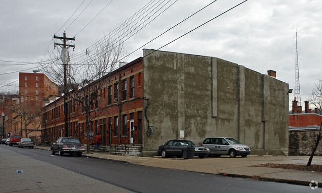
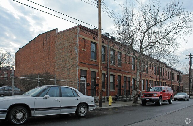
Property Record
2124 Kindel Ave, Cincinnati, OH 45214

NEARBY LISTINGS FOR SALE OR LEASE
Property Detail
2124 Kindel Ave
Cincinnati, OH-KY-IN
Avery Sub
132-0001-0101
2124-50 KINDEL AV 218X85 LTS 11 TH 18 PT 22 J W COLEMAN AND E&F AVERY SUBS PRS 101 TH 109 CONS
Municipalproperty
Hamilton
X
Ohio
21037C0010E
11
0
0.43 AC
2025
West End
026900
Cincinnati/Dayton
24,684 SF
DEMOGRAPHICS near 2124 Kindel Ave
1 Mile
3 Mile
5 Mile
2024 Total Population
21,080
154,279
341,209
2029 Population
21,354
157,246
344,588
Pop Growth 2024-2029
+ 1.30%
+ 1.92%
+ 0.99%
Average Age
32
35
37
2024 Total Households
8,944
69,315
149,167
HH Growth 2024-2029
+ 1.49%
+ 2.11%
+ 1.03%
Median Household Inc
$28,740
$40,212
$46,742
Avg Household Size
2.10
2.00
2.10
2024 Avg HH Vehicles
1.00
1.00
1.00
Median Home Value
$258,204
$206,923
$185,354
Median Year Built
1949
1950
1952
Nearby Places
Map Layers
Map Styles
 Street
 Aerial
- Restaurants
- Banks
- Shops
- Fitness
- Groceries
PUBLIC TRANSPORTATION
TRANSIT/SUBWAY
Brewery District Station, Elm & Henry (Streetcar - OTR - Banks - Southwest Ohio Regional Transit Authority)
DRIVE
WALK
Distance
Brewery District Station, Elm & Henry (Streetcar - OTR - Banks - Southwest Ohio Regional Transit Authority)
2 min
15 min
0.8 mi
Findlay Market-Elm Station, Elm & Glass Alley (Streetcar - OTR - Banks - Southwest Ohio Regional Transit Authority)
DRIVE
WALK
Distance
Findlay Market-Elm Station, Elm & Glass Alley (Streetcar - OTR - Banks - Southwest Ohio Regional Transit Authority)
3 min
18 min
1.0 mi
Findlay Market-Race Station, Race & Elder (Streetcar - OTR - Banks - Southwest Ohio Regional Transit Authority)
DRIVE
WALK
Distance
Findlay Market-Race Station, Race & Elder (Streetcar - OTR - Banks - Southwest Ohio Regional Transit Authority)
3 min
19 min
1.0 mi
Elm & Liberty Station (Streetcar - OTR - Banks - Southwest Ohio Regional Transit Authority)
DRIVE
WALK
Distance
Elm & Liberty Station (Streetcar - OTR - Banks - Southwest Ohio Regional Transit Authority)
3 min
20 min
1.1 mi
COMMUTER RAIL
Cincinnati Union Terminal (Cardinal - Amtrak)
DRIVE
WALK
Distance
Cincinnati Union Terminal (Cardinal - Amtrak)
4 min
1.2 mi
AIRPORT
Cincinnati/Northern Kentucky International
DRIVE
WALK
Distance
Cincinnati/Northern Kentucky International
29 min
15.3 mi
Freight Ports
Port of Toledo
DRIVE
WALK
Distance
Port of Toledo
239 min
204.6 mi
Nearby Properties
Address
Land Use
TOTAL SIZE
Lot Size
Zoning
Address
Land Use
TOTAL SIZE
Lot Size
Zoning
77.73 AC
IR
Address
Land Use
TOTAL SIZE
Lot Size
Zoning
6.35 AC
IR
Address
Land Use
TOTAL SIZE
Lot Size
Zoning
39.99 AC
MG
Address
Land Use
TOTAL SIZE
Lot Size
Zoning
11.82 AC
Address
Land Use
TOTAL SIZE
Lot Size
Zoning
11.62 AC
Address
Land Use
TOTAL SIZE
Lot Size
Zoning
19.36 AC
Address
Land Use
TOTAL SIZE
Lot Size
Zoning
17.10 AC
DD
Address
Land Use
TOTAL SIZE
Lot Size
Zoning
1.97 AC
DD
Address
Land Use
TOTAL SIZE
Lot Size
Zoning
11.41 AC
IR
Address
Land Use
TOTAL SIZE
Lot Size
Zoning
22.45 AC
Address
Land Use
TOTAL SIZE
Lot Size
Zoning
60,750 SF
1.52 AC
Address
Land Use
TOTAL SIZE
Lot Size
Zoning
2.60 AC
Address
Land Use
TOTAL SIZE
Lot Size
Zoning
9.55 AC
Address
Land Use
TOTAL SIZE
Lot Size
Zoning
3.09 AC
Address
Land Use
TOTAL SIZE
Lot Size
Zoning
2.80 AC
IR
Address
Land Use
TOTAL SIZE
Lot Size
Zoning
3.40 AC
IR
Address
Land Use
TOTAL SIZE
Lot Size
Zoning
89,500 SF
0.58 AC
Address
Land Use
TOTAL SIZE
Lot Size
Zoning
Address
Land Use
TOTAL SIZE
Lot Size
Zoning
290,233 SF
Address
Land Use
TOTAL SIZE
Lot Size
Zoning
3.51 AC
DD
Address
Land Use
TOTAL SIZE
Lot Size
Zoning
9,962 SF
712 AC
Address
Land Use
TOTAL SIZE
Lot Size
Zoning
Address
Land Use
TOTAL SIZE
Lot Size
Zoning
9.14 AC
Address
Land Use
TOTAL SIZE
Lot Size
Zoning
298,611 SF
Address
Land Use
TOTAL SIZE
Lot Size
Zoning
2.46 AC
Address
Land Use
TOTAL SIZE
Lot Size
Zoning
7.14 AC
Address
Land Use
TOTAL SIZE
Lot Size
Zoning
256,000 SF
Address
Land Use
TOTAL SIZE
Lot Size
Zoning
1.95 AC
Address
Land Use
TOTAL SIZE
Lot Size
Zoning
Address
Land Use
TOTAL SIZE
Lot Size
Zoning
263,300 SF
1.74 AC
The World's #1 Commercial Real Estate Marketplace
Connect with us
© 2026 CoStar Group
The information above has been obtained from sources believed reliable. While we do not doubt its accuracy we have not verified it and make no guarantee, warranty or representation about it. It is your responsibility to independently confirm its accuracy and completeness. Any projections, opinions, assumptions, or estimates used are for example only and do not represent the current or future performance of the property. The value of this transaction to you depends on tax and other factors which should be evaluated by your tax, financial, and legal advisors. You and your advisors should conduct a careful, independent investigation of the property to determine to your satisfaction the suitability of the property for your needs.