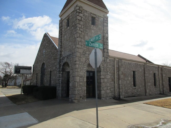
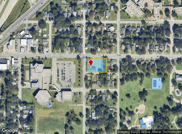
Property Record
2124 W 41St St, Tulsa, OK 74107
NEARBY LISTINGS FOR SALE OR LEASE
-
-
View all Tulsa listings for sale on LoopNet.com
Property Detail
2124 W 41St St
Tulsa, OK
Clinton Home Addn
09000-92-27-06530
LTS 3 THRU 6 BLK 1
Religious
Tulsa
X
Oklahoma
40143C0332L
5
0
0.65 AC
2025
West
004800
Tulsa
8,669 SF
DEMOGRAPHICS near 2124 W 41St St
1 Mile
3 Mile
5 Mile
2024 Total Population
5,618
42,868
138,132
2029 Population
5,835
44,504
143,723
Pop Growth 2024-2029
+ 3.86%
+ 3.82%
+ 4.05%
Average Age
40
40
39
2024 Total Households
2,273
19,951
62,326
HH Growth 2024-2029
+ 3.92%
+ 3.96%
+ 4.19%
Median Household Inc
$49,064
$53,819
$52,828
Avg Household Size
2.30
2.10
2.10
2024 Avg HH Vehicles
2.00
2.00
2.00
Median Home Value
$79,999
$174,775
$207,857
Median Year Built
1954
1965
1967
Nearby Places
Map Layers
Map Styles
 Street
 Aerial
- Restaurants
- Banks
- Shops
- Fitness
- Groceries
PUBLIC TRANSPORTATION
AIRPORT
Tulsa International
DRIVE
WALK
Distance
Tulsa International
20 min
13.4 mi
Freight Ports
Tulsa Port Of Catoosa
DRIVE
WALK
Distance
Tulsa Port Of Catoosa
30 min
22.6 mi
SALE & LEASE HISTORY
LISTING DATE
SALE/LEASE

Feb 17, 2018
For Sale
Aug 11, 2018
For Sale
Nearby Properties
Address
Land Use
TOTAL SIZE
Lot Size
Zoning
Address
Land Use
TOTAL SIZE
Lot Size
Zoning
1,134,776 SF
35.85 AC
CN
Address
Land Use
TOTAL SIZE
Lot Size
Zoning
49,992 SF
33.23 AC
AG
Address
Land Use
TOTAL SIZE
Lot Size
Zoning
114,791 SF
23.40 AC
RE
Address
Land Use
TOTAL SIZE
Lot Size
Zoning
290,963 SF
10.77 AC
RM1
Address
Land Use
TOTAL SIZE
Lot Size
Zoning
119,056 SF
28.06 AC
CM
Address
Land Use
TOTAL SIZE
Lot Size
Zoning
137,215 SF
5.08 AC
RM3
Address
Land Use
TOTAL SIZE
Lot Size
Zoning
88,702 SF
8.27 AC
IM
Address
Land Use
TOTAL SIZE
Lot Size
Zoning
21,693 SF
4.24 AC
Address
Land Use
TOTAL SIZE
Lot Size
Zoning
106,743 SF
4.34 AC
MX1U55
Address
Land Use
TOTAL SIZE
Lot Size
Zoning
89,640 SF
5.47 AC
MX1U55
Address
Land Use
TOTAL SIZE
Lot Size
Zoning
100,857 SF
4.04 AC
MX1U55
Address
Land Use
TOTAL SIZE
Lot Size
Zoning
132,105 SF
9.32 AC
RS3
Address
Land Use
TOTAL SIZE
Lot Size
Zoning
28,953 SF
10.32 AC
RS2
Address
Land Use
TOTAL SIZE
Lot Size
Zoning
78,442 SF
31.24 AC
IM
Address
Land Use
TOTAL SIZE
Lot Size
Zoning
53,220 SF
4.93 AC
CH
Address
Land Use
TOTAL SIZE
Lot Size
Zoning
589,648 SF
2.84 AC
RM3
Address
Land Use
TOTAL SIZE
Lot Size
Zoning
11,349 SF
0.61 AC
RM2
Address
Land Use
TOTAL SIZE
Lot Size
Zoning
84,791 SF
8.04 AC
RS3
Address
Land Use
TOTAL SIZE
Lot Size
Zoning
1,123,266 SF
87.29 AC
IM
Address
Land Use
TOTAL SIZE
Lot Size
Zoning
110,382 SF
9.81 AC
RS3
Address
Land Use
TOTAL SIZE
Lot Size
Zoning
35,845 SF
14.38 AC
CS
Address
Land Use
TOTAL SIZE
Lot Size
Zoning
394,728 SF
5.44 AC
CH
Address
Land Use
TOTAL SIZE
Lot Size
Zoning
102,070 SF
6.92 AC
IM
Address
Land Use
TOTAL SIZE
Lot Size
Zoning
198 SF
19.81 AC
RS3
Address
Land Use
TOTAL SIZE
Lot Size
Zoning
6,162 SF
4.25 AC
CH
Address
Land Use
TOTAL SIZE
Lot Size
Zoning
21,768 SF
3.41 AC
RS2
Address
Land Use
TOTAL SIZE
Lot Size
Zoning
72,690 SF
8.04 AC
RS3
Address
Land Use
TOTAL SIZE
Lot Size
Zoning
27,225 SF
2.19 AC
MX1U55
Address
Land Use
TOTAL SIZE
Lot Size
Zoning
143,520 SF
25.14 AC
IM
Address
Land Use
TOTAL SIZE
Lot Size
Zoning
82,843 SF
4.10 AC
RS3
The World's #1 Commercial Real Estate Marketplace
Connect with us
© 2025 CoStar Group
The information above has been obtained from sources believed reliable. While we do not doubt its accuracy we have not verified it and make no guarantee, warranty or representation about it. It is your responsibility to independently confirm its accuracy and completeness. Any projections, opinions, assumptions, or estimates used are for example only and do not represent the current or future performance of the property. The value of this transaction to you depends on tax and other factors which should be evaluated by your tax, financial, and legal advisors. You and your advisors should conduct a careful, independent investigation of the property to determine to your satisfaction the suitability of the property for your needs.