Property Record
2125 E Highway 540A E, Lakeland, FL 33813
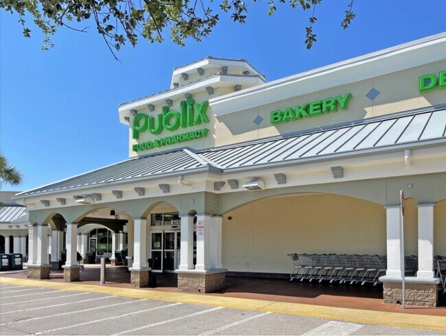

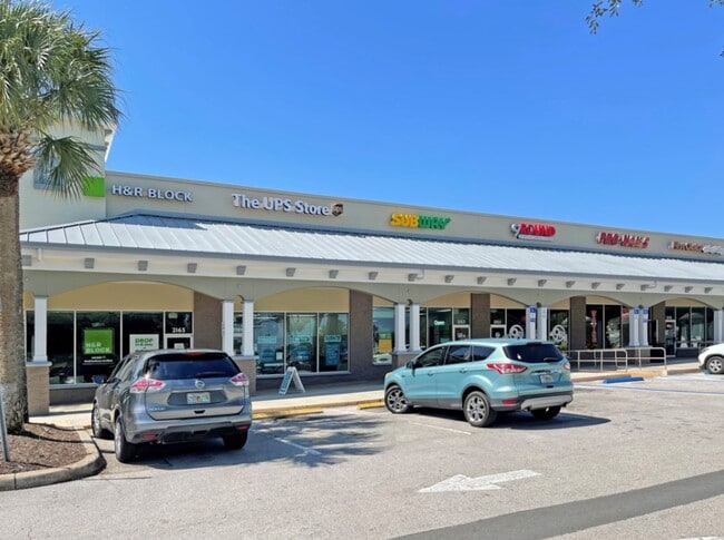
Property Detail
2125 E Highway 540A E
24-29-20-000000-011010
NE1/4 OF NE1/4 OF NE1/4 LESS R/W ON N & E SIDES & LESS ADD R/W PER OR 4145-2245 & LESS COMM NE COR OF SEC RUN W ALONG N LN SEC 20 260 FT RUN S 75 FT TO S R/W LN CR 540-A AS REC IN OR 4145 PG 2245 & POB CONT S 48.04 FT RUN S 25 DEG 2654E 47.58 FT RUN
Regionalshoppingcenterormallwithanchorstore
POLK
RC
Florida
B and X Area of moderate flood hazard, usually the area between the limits of the 100-year and 500-year floods.
7.53 AC
2024
Polk County
2025
Tampa/St Petersburg
011821
Lakeland-Winter Haven, FL
39,748 SF
NEARBY LISTINGS FOR SALE OR LEASE
DEMOGRAPHICS near 2125 E Highway 540A E
1 mile
3 mile
5 mile
2025 Total Population
7,119
47,000
104,452
2030 Population
8,056
52,964
117,965
Pop Growth 2025-2030
+ 13.16%
+ 12.69%
+ 12.94%
Average Age
41
41
40
2025 Total Households
2,433
17,092
40,167
HH Growth 2025-2030
+ 13.44%
+ 12.99%
+ 13.23%
Median Household Inc
$127,850
$111,093
$88,629
Avg Household Size
2.90
2.70
2.60
2025 Avg HH Vehicles
2.00
2.00
2.00
Median Home Value
$435,182
$391,089
$346,448
Median Year Built
2001
1994
1990
Nearby Places
Map Layers
Map Styles
 Street
 Aerial
Transit
 Traffic
 Biking
Places
Listings with unknown addresses are not visible on the map
- Restaurants
- Banks
- Shops
- Fitness
- Groceries
PUBLIC TRANSPORTATION
COMMUTER RAIL
Lakeland (Silver Star - Amtrak)
Drive
Walk
Distance
Lakeland (Silver Star - Amtrak)
15 min
8.3 mi
Freight Ports
Port of Tampa Bay
Drive
Walk
Distance
Port of Tampa Bay
54 min
40.5 mi
Nearby Properties
Address
Land Use
TOTAL SIZE
Lot Size
Zoning
Address
Land Use
TOTAL SIZE
Lot Size
Zoning
480,363 SF
40.15 AC
Address
Land Use
TOTAL SIZE
Lot Size
Zoning
292,243 SF
11.94 AC
PUD
Address
Land Use
TOTAL SIZE
Lot Size
Zoning
336,260 SF
93.82 AC
RE1
Address
Land Use
TOTAL SIZE
Lot Size
Zoning
341,795 SF
37.28 AC
Address
Land Use
TOTAL SIZE
Lot Size
Zoning
75,580 SF
8.92 AC
RE1
Address
Land Use
TOTAL SIZE
Lot Size
Zoning
106,312 SF
22.64 AC
RC
Address
Land Use
TOTAL SIZE
Lot Size
Zoning
76,527 SF
17.51 AC
R1
Address
Land Use
TOTAL SIZE
Lot Size
Zoning
101,103 SF
13.87 AC
Address
Land Use
TOTAL SIZE
Lot Size
Zoning
147,718 SF
52.29 AC
PUD
Address
Land Use
TOTAL SIZE
Lot Size
Zoning
95,955 SF
14.37 AC
Address
Land Use
TOTAL SIZE
Lot Size
Zoning
146,700 SF
12.30 AC
C4
Address
Land Use
TOTAL SIZE
Lot Size
Zoning
119,901 SF
8.46 AC
Address
Land Use
TOTAL SIZE
Lot Size
Zoning
199,906 SF
19.73 AC
R2
Address
Land Use
TOTAL SIZE
Lot Size
Zoning
73,090 SF
5.81 AC
PUD
Address
Land Use
TOTAL SIZE
Lot Size
Zoning
75,566 SF
12 AC
RA1
Address
Land Use
TOTAL SIZE
Lot Size
Zoning
75,210 SF
7.68 AC
Address
Land Use
TOTAL SIZE
Lot Size
Zoning
149,528 SF
21.75 AC
Address
Land Use
TOTAL SIZE
Lot Size
Zoning
61,474 SF
8.18 AC
PUD
Address
Land Use
TOTAL SIZE
Lot Size
Zoning
110,784 SF
15.58 AC
Address
Land Use
TOTAL SIZE
Lot Size
Zoning
115,162 SF
17.89 AC
RE1
Address
Land Use
TOTAL SIZE
Lot Size
Zoning
54,315 SF
10.60 AC
C4
Address
Land Use
TOTAL SIZE
Lot Size
Zoning
123,899 SF
5.12 AC
C4
Address
Land Use
TOTAL SIZE
Lot Size
Zoning
158,234 SF
14.41 AC
Address
Land Use
TOTAL SIZE
Lot Size
Zoning
42,032 SF
2.68 AC
Address
Land Use
TOTAL SIZE
Lot Size
Zoning
101,500 SF
8.47 AC
Address
Land Use
TOTAL SIZE
Lot Size
Zoning
39,936 SF
3.16 AC
C4
Address
Land Use
TOTAL SIZE
Lot Size
Zoning
122,724 SF
14.05 AC
Address
Land Use
TOTAL SIZE
Lot Size
Zoning
63,640 SF
8.81 AC
C4
Address
Land Use
TOTAL SIZE
Lot Size
Zoning
62,749 SF
7.35 AC
Address
Land Use
TOTAL SIZE
Lot Size
Zoning
27,425 SF
8.02 AC
The World's #1 Commercial Real Estate Marketplace
Connect with us
© 2026 CoStar Group
The information above has been obtained from sources believed reliable. While we do not doubt its accuracy we have not verified it and make no guarantee, warranty or representation about it. It is your responsibility to independently confirm its accuracy and completeness. Any projections, opinions, assumptions, or estimates used are for example only and do not represent the current or future performance of the property. The value of this transaction to you depends on tax and other factors which should be evaluated by your tax, financial, and legal advisors. You and your advisors should conduct a careful, independent investigation of the property to determine to your satisfaction the suitability of the property for your needs.