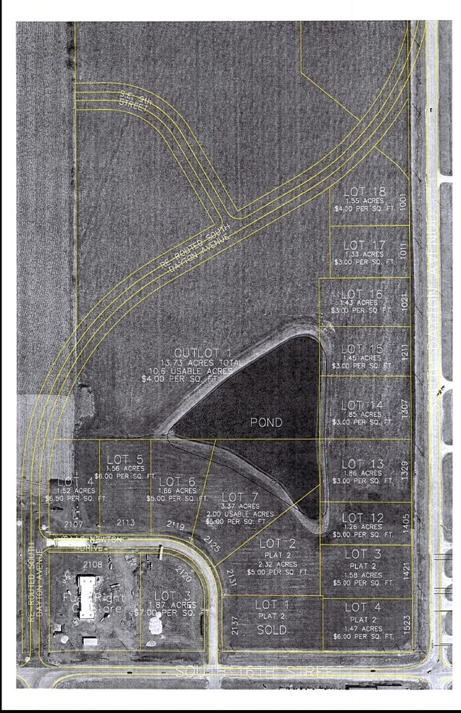
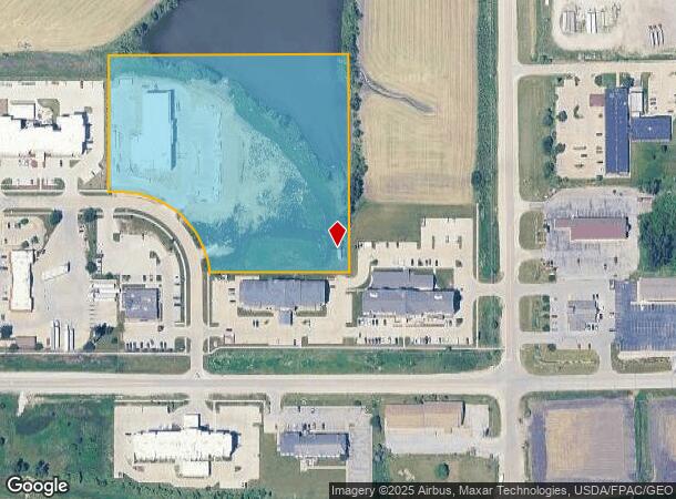
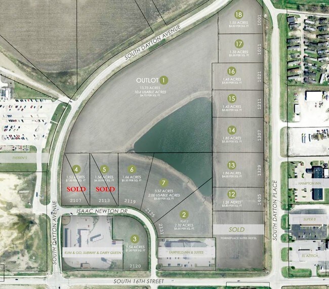
Property Record
2125 Isaac Newton Dr, Ames, IA 50010
NEARBY LISTINGS FOR SALE OR LEASE
Property Detail
2125 Isaac Newton Dr
Ames, IA
South Gateway Development
09-12-476-045
SOUTH GATEWAY DEVELOPMENT PARCEL D LOTS 6 & 7 ANDSOUTH GATEWAY DEVELOPMENT PLAT 2 LOT 2SLIDE 628 PG 3 AMES
Hotelormotel
Story
AE
Iowa
19169C0164F
6,7
2024
7.25 AC
2025
East Ames
001000
Other Market Areas
58,109 SF
DEMOGRAPHICS near 2125 Isaac Newton Dr
1 Mile
3 Mile
5 Mile
2024 Total Population
511
17,549
55,841
2029 Population
522
17,998
57,480
Pop Growth 2024-2029
+ 2.15%
+ 2.56%
+ 2.94%
Average Age
40
34
34
2024 Total Households
205
7,770
23,046
HH Growth 2024-2029
+ 1.95%
+ 2.82%
+ 3.33%
Median Household Inc
$60,625
$59,973
$55,941
Avg Household Size
2.50
2.00
2.10
2024 Avg HH Vehicles
2.00
2.00
2.00
Median Home Value
$318,750
$196,071
$247,988
Median Year Built
1975
1971
1988
Nearby Places
Map Layers
Map Styles
 Street
 Aerial
- Restaurants
- Banks
- Shops
- Fitness
- Groceries
PUBLIC TRANSPORTATION
AIRPORT
Des Moines International
DRIVE
WALK
Distance
Des Moines International
52 min
37.2 mi
SALE & LEASE HISTORY
LISTING DATE
SALE/LEASE

Mar 29, 2017
For Sale
Apr 26, 2017
For Sale
Nearby Properties
Address
Land Use
TOTAL SIZE
Lot Size
Zoning
Address
Land Use
TOTAL SIZE
Lot Size
Zoning
2,400 SF
146.13 AC
PI
Address
Land Use
TOTAL SIZE
Lot Size
Zoning
54,112 SF
12.70 AC
Address
Land Use
TOTAL SIZE
Lot Size
Zoning
576,476 SF
23.76 AC
GI
Address
Land Use
TOTAL SIZE
Lot Size
Zoning
188,204 SF
70.81 AC
A1
Address
Land Use
TOTAL SIZE
Lot Size
Zoning
215,689 SF
22.56 AC
HOC
Address
Land Use
TOTAL SIZE
Lot Size
Zoning
75,302 SF
16.66 AC
HOC
Address
Land Use
TOTAL SIZE
Lot Size
Zoning
177,201 SF
26.29 AC
Address
Land Use
TOTAL SIZE
Lot Size
Zoning
3,500 SF
56.27 AC
GI
Address
Land Use
TOTAL SIZE
Lot Size
Zoning
262,786 SF
16.05 AC
GI
Address
Land Use
TOTAL SIZE
Lot Size
Zoning
78,379 SF
7.92 AC
SHM
Address
Land Use
TOTAL SIZE
Lot Size
Zoning
120,842 SF
26.68 AC
PI
Address
Land Use
TOTAL SIZE
Lot Size
Zoning
52,980 SF
8.53 AC
PI
Address
Land Use
TOTAL SIZE
Lot Size
Zoning
93,813 SF
7.11 AC
GI
Address
Land Use
TOTAL SIZE
Lot Size
Zoning
384 SF
62.77 AC
GI
Address
Land Use
TOTAL SIZE
Lot Size
Zoning
171,800 SF
19.34 AC
PI
Address
Land Use
TOTAL SIZE
Lot Size
Zoning
115,338 SF
16.41 AC
HOC
Address
Land Use
TOTAL SIZE
Lot Size
Zoning
35,264 SF
11.88 AC
Address
Land Use
TOTAL SIZE
Lot Size
Zoning
122,502 SF
10.96 AC
HOC
Address
Land Use
TOTAL SIZE
Lot Size
Zoning
114,744 SF
14.35 AC
HOC
Address
Land Use
TOTAL SIZE
Lot Size
Zoning
34,368 SF
5.01 AC
RI
Address
Land Use
TOTAL SIZE
Lot Size
Zoning
75,122 SF
3.79 AC
HOC
Address
Land Use
TOTAL SIZE
Lot Size
Zoning
32,383 SF
8.36 AC
Address
Land Use
TOTAL SIZE
Lot Size
Zoning
24,274 SF
10.39 AC
Address
Land Use
TOTAL SIZE
Lot Size
Zoning
7,200 SF
4.32 AC
HOC
Address
Land Use
TOTAL SIZE
Lot Size
Zoning
99,962 SF
4.58 AC
Address
Land Use
TOTAL SIZE
Lot Size
Zoning
101,006 SF
14.35 AC
PI
Address
Land Use
TOTAL SIZE
Lot Size
Zoning
14,837 SF
8 AC
GI
Address
Land Use
TOTAL SIZE
Lot Size
Zoning
88,628 SF
10.01 AC
HOC
Address
Land Use
TOTAL SIZE
Lot Size
Zoning
49,699 SF
11.30 AC
PI
Address
Land Use
TOTAL SIZE
Lot Size
Zoning
67,700 SF
3.07 AC
The World's #1 Commercial Real Estate Marketplace
Connect with us
© 2026 CoStar Group
The information above has been obtained from sources believed reliable. While we do not doubt its accuracy we have not verified it and make no guarantee, warranty or representation about it. It is your responsibility to independently confirm its accuracy and completeness. Any projections, opinions, assumptions, or estimates used are for example only and do not represent the current or future performance of the property. The value of this transaction to you depends on tax and other factors which should be evaluated by your tax, financial, and legal advisors. You and your advisors should conduct a careful, independent investigation of the property to determine to your satisfaction the suitability of the property for your needs.