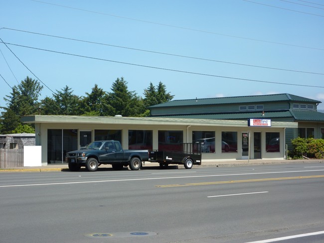
Property Record
2125 Nw Highway 101, Lincoln City, OR 97367


Property Detail
2125 Nw Highway 101
R34579
OCEAN LAKE NO. 1, BLOCK 2, LOT 1,EXC NELY 40OF, DOC202406880
Agriculturalland
Lincoln
G-C
Oregon
B and X Area of moderate flood hazard, usually the area between the limits of the 100-year and 500-year floods.
1
0
0.11 AC
2025
Oregon West Area
950304
Other Market Areas
3,534 SF
Newport, OR
NEARBY LISTINGS FOR SALE OR LEASE
DEMOGRAPHICS near 2125 Nw Highway 101
1 mile
3 mile
5 mile
2025 Total Population
4,661
10,913
13,309
2030 Population
4,750
11,169
13,538
Pop Growth 2025-2030
+ 1.91%
+ 2.35%
+ 1.72%
Average Age
48
48
48
2025 Total Households
2,177
5,002
6,131
HH Growth 2025-2030
+ 1.84%
+ 2.34%
+ 1.71%
Median Household Inc
$55,602
$57,970
$58,594
Avg Household Size
2.10
2.10
2.10
2025 Avg HH Vehicles
2.00
2.00
2.00
Median Home Value
$447,404
$452,215
$454,374
Median Year Built
1977
1983
1982
Nearby Places
Map Layers
Map Styles
 Street
 Aerial
Layers
 Traffic
 Biking
Places
Listings with unknown addresses are not visible on the map
- Restaurants
- Banks
- Shops
- Fitness
- Groceries
SALE & LEASE HISTORY
LISTING DATE
SALE/LEASE

Feb 29, 2024
For Sale
Nearby Properties
Address
Land Use
TOTAL SIZE
Lot Size
Zoning
Address
Land Use
TOTAL SIZE
Lot Size
Zoning
2.76 AC
R-C
Address
Land Use
TOTAL SIZE
Lot Size
Zoning
3.50 AC
P-C
Address
Land Use
TOTAL SIZE
Lot Size
Zoning
257,594 SF
14.65 AC
G-C
Address
Land Use
TOTAL SIZE
Lot Size
Zoning
47,394 SF
4.42 AC
R-C
Address
Land Use
TOTAL SIZE
Lot Size
Zoning
45,353 SF
11.91 AC
R1
Address
Land Use
TOTAL SIZE
Lot Size
Zoning
100,000 SF
20 AC
R-7.5
Address
Land Use
TOTAL SIZE
Lot Size
Zoning
24,700 SF
19.14 AC
P-C
Address
Land Use
TOTAL SIZE
Lot Size
Zoning
22.27 AC
P
Address
Land Use
TOTAL SIZE
Lot Size
Zoning
118,172 SF
1.24 AC
G-C
Address
Land Use
TOTAL SIZE
Lot Size
Zoning
1,997 SF
4.45 AC
R1-7.5
Address
Land Use
TOTAL SIZE
Lot Size
Zoning
26,024 SF
0.98 AC
G-C
Address
Land Use
TOTAL SIZE
Lot Size
Zoning
35,002 SF
2.20 AC
P
Address
Land Use
TOTAL SIZE
Lot Size
Zoning
24,987 SF
0.88 AC
R-C
Address
Land Use
TOTAL SIZE
Lot Size
Zoning
69,750 SF
2.70 AC
P-C
Address
Land Use
TOTAL SIZE
Lot Size
Zoning
55,059 SF
6.12 AC
R-1-7.5
Address
Land Use
TOTAL SIZE
Lot Size
Zoning
24,360 SF
0.93 AC
R-C
Address
Land Use
TOTAL SIZE
Lot Size
Zoning
8,874 SF
2.74 AC
G-C
Address
Land Use
TOTAL SIZE
Lot Size
Zoning
46,370 SF
16.27 AC
R-M
Address
Land Use
TOTAL SIZE
Lot Size
Zoning
25,448 SF
1.79 AC
OP-OF
Address
Land Use
TOTAL SIZE
Lot Size
Zoning
44,075 SF
1.42 AC
R-C
Address
Land Use
TOTAL SIZE
Lot Size
Zoning
720 SF
4.95 AC
R-M
Address
Land Use
TOTAL SIZE
Lot Size
Zoning
78,833 SF
8.25 AC
G-C
Address
Land Use
TOTAL SIZE
Lot Size
Zoning
4.28 AC
R-C
Address
Land Use
TOTAL SIZE
Lot Size
Zoning
34,230 SF
1.31 AC
R-M
Address
Land Use
TOTAL SIZE
Lot Size
Zoning
20.37 AC
R-C
The World's #1 Commercial Real Estate Marketplace
Connect with us
© 2026 CoStar Group
The information above has been obtained from sources believed reliable. While we do not doubt its accuracy we have not verified it and make no guarantee, warranty or representation about it. It is your responsibility to independently confirm its accuracy and completeness. Any projections, opinions, assumptions, or estimates used are for example only and do not represent the current or future performance of the property. The value of this transaction to you depends on tax and other factors which should be evaluated by your tax, financial, and legal advisors. You and your advisors should conduct a careful, independent investigation of the property to determine to your satisfaction the suitability of the property for your needs.