Property Record
21251 E 152Nd Ave, Brighton, CO 80603
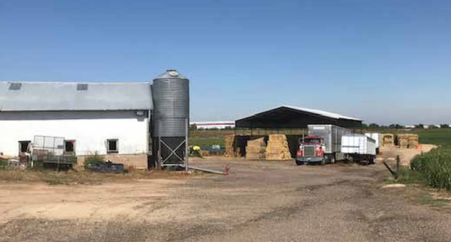
Property Detail
21251 E 152Nd Ave
1569-00-0-00-126
SECT,TWN,RNG:11-1-66 DESC: BEG AT PT ON S LN SEC 11 1390 FT W OF SE COR SD SEC TH NELY ON ABANDONED GRADE OF BURL RY 2385 FT TO E LN SEC 11 TH N ON E LN SD SEC 1050 FT TO E LN OF ROW BURL RY TH SWLY ON E LN OF ROW 2550 FT TH S 1328 FT TO S LN SD SEC
Agriculturalland
Adams
A3
Colorado
A Areas with a 1% annual chance of flooding and a 26% chance of flooding over the life of a 30-year mortgage.
66.15 AC
2024
DIA
2025
Denver
008553
Denver-Aurora-Centennial, CO
928 SF
NEARBY LISTINGS FOR SALE OR LEASE
DEMOGRAPHICS near 21251 E 152Nd Ave
1 mile
3 mile
5 mile
2024 Total Population
2,970
30,985
54,697
2029 Population
3,095
33,869
59,005
Pop Growth 2024-2029
+ 4.21%
+ 9.31%
+ 7.88%
Average Age
34
36
36
2024 Total Households
937
10,067
18,042
HH Growth 2024-2029
+ 4.16%
+ 9.44%
+ 7.96%
Median Household Inc
$116,682
$100,054
$89,041
Avg Household Size
3.10
3.00
3.00
2024 Avg HH Vehicles
2.00
2.00
2.00
Median Home Value
$452,499
$447,756
$442,658
Median Year Built
2004
2007
2002
Nearby Places
Map Layers
Map Styles
 Street
 Aerial
Transit
 Traffic
 Biking
Places
Listings with unknown addresses are not visible on the map
- Restaurants
- Banks
- Shops
- Fitness
- Groceries
PUBLIC TRANSPORTATION
AIRPORT
Denver International
Drive
Walk
Distance
Denver International
25 min
19.3 mi
Freight Ports
Tulsa Port Of Catoosa
Drive
Walk
Distance
Tulsa Port Of Catoosa
732 min
713.5 mi
SALE & LEASE HISTORY
LISTING DATE
SALE/LEASE

Mar 02, 2020
For Sale
Apr 03, 2023
For Lease
Nearby Properties
Address
Land Use
TOTAL SIZE
Lot Size
Zoning
Address
Land Use
TOTAL SIZE
Lot Size
Zoning
374,830 SF
49.94 AC
Address
Land Use
TOTAL SIZE
Lot Size
Zoning
275,217 SF
27.30 AC
Address
Land Use
TOTAL SIZE
Lot Size
Zoning
614,010 SF
41.81 AC
Address
Land Use
TOTAL SIZE
Lot Size
Zoning
546,000 SF
35.70 AC
Address
Land Use
TOTAL SIZE
Lot Size
Zoning
1,305,700 SF
103.31 AC
A3
Address
Land Use
TOTAL SIZE
Lot Size
Zoning
526,400 SF
29.21 AC
Address
Land Use
TOTAL SIZE
Lot Size
Zoning
243,589 SF
16.71 AC
Address
Land Use
TOTAL SIZE
Lot Size
Zoning
11,840 SF
6 AC
Address
Land Use
TOTAL SIZE
Lot Size
Zoning
198,433 SF
40.09 AC
Address
Land Use
TOTAL SIZE
Lot Size
Zoning
352,240 SF
19.96 AC
Address
Land Use
TOTAL SIZE
Lot Size
Zoning
300,300 SF
16.38 AC
Address
Land Use
TOTAL SIZE
Lot Size
Zoning
268,226 SF
13.89 AC
Address
Land Use
TOTAL SIZE
Lot Size
Zoning
266,280 SF
12.68 AC
Address
Land Use
TOTAL SIZE
Lot Size
Zoning
123,627 SF
11.22 AC
Address
Land Use
TOTAL SIZE
Lot Size
Zoning
289,524 SF
15 AC
Address
Land Use
TOTAL SIZE
Lot Size
Zoning
109,032 SF
13.88 AC
Address
Land Use
TOTAL SIZE
Lot Size
Zoning
61,700 SF
10 AC
Address
Land Use
TOTAL SIZE
Lot Size
Zoning
256,102 SF
6.66 AC
Address
Land Use
TOTAL SIZE
Lot Size
Zoning
174,724 SF
14.75 AC
Address
Land Use
TOTAL SIZE
Lot Size
Zoning
69,919 SF
6.73 AC
Address
Land Use
TOTAL SIZE
Lot Size
Zoning
70,573 SF
7.83 AC
Address
Land Use
TOTAL SIZE
Lot Size
Zoning
101,917 SF
3.72 AC
Address
Land Use
TOTAL SIZE
Lot Size
Zoning
140,227 SF
12.33 AC
Address
Land Use
TOTAL SIZE
Lot Size
Zoning
40,000 SF
4.10 AC
Address
Land Use
TOTAL SIZE
Lot Size
Zoning
85,968 SF
6.59 AC
Address
Land Use
TOTAL SIZE
Lot Size
Zoning
58,000 SF
2.37 AC
Address
Land Use
TOTAL SIZE
Lot Size
Zoning
168,506 SF
21.67 AC
Address
Land Use
TOTAL SIZE
Lot Size
Zoning
43,948 SF
3 AC
The World's #1 Commercial Real Estate Marketplace
Connect with us
© 2026 CoStar Group
The information above has been obtained from sources believed reliable. While we do not doubt its accuracy we have not verified it and make no guarantee, warranty or representation about it. It is your responsibility to independently confirm its accuracy and completeness. Any projections, opinions, assumptions, or estimates used are for example only and do not represent the current or future performance of the property. The value of this transaction to you depends on tax and other factors which should be evaluated by your tax, financial, and legal advisors. You and your advisors should conduct a careful, independent investigation of the property to determine to your satisfaction the suitability of the property for your needs.