Property Record
21263 Lankford Hwy, Cape Charles, VA 23310
NEARBY LISTINGS FOR SALE OR LEASE
Property Detail
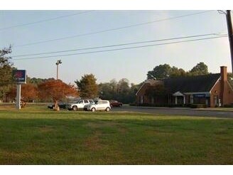
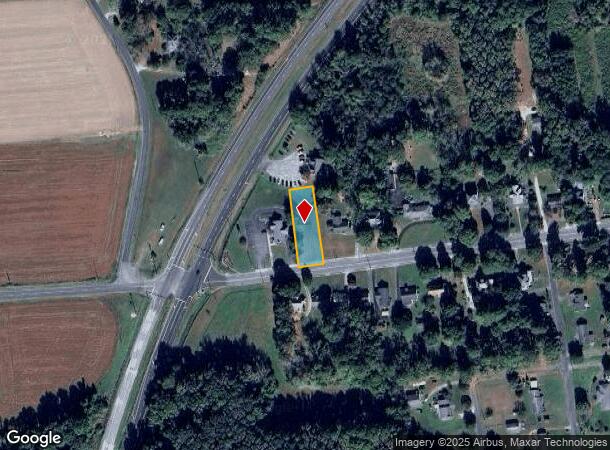
21263 Lankford Hwy
Financialbuilding
RT. #13 & T680 SUNTRUST BANK
X
Northampton
51131C0315F
Virginia
2024
1.05 AC
2024
Virginia Regional
930301
Other Market Areas
2,166 SF
84C2-2-4
DEMOGRAPHICS near 21263 Lankford Hwy
1 Mile
3 Mile
5 Mile
2024 Total Population
552
4,186
5,204
2029 Population
512
4,207
5,174
Pop Growth 2024-2029
(7.25%)
+ 0.50%
(0.58%)
Average Age
46
48
47
2024 Total Households
238
1,960
2,391
HH Growth 2024-2029
(7.56%)
+ 0.87%
(0.17%)
Median Household Inc
$39,999
$47,644
$49,608
Avg Household Size
2.30
2.10
2.10
2024 Avg HH Vehicles
2.00
2.00
2.00
Median Home Value
$174,264
$332,131
$324,932
Median Year Built
1977
1982
1984
Nearby Places
- Restaurants
- Banks
- Shops
- Fitness
- Groceries
PUBLIC TRANSPORTATION
AIRPORT
Norfolk International
DRIVE
WALK
Distance
Norfolk International
56 min
38.1 mi
Freight Ports
Virginia Port Authority - Norfolk
DRIVE
WALK
Distance
Virginia Port Authority - Norfolk
66 min
42.9 mi
Nearby Properties
Address
Land Use
TOTAL SIZE
Lot Size
Zoning
Address
Land Use
TOTAL SIZE
Lot Size
Zoning
Address
Land Use
TOTAL SIZE
Lot Size
Zoning
17.05 AC
Address
Land Use
TOTAL SIZE
Lot Size
Zoning
Address
Land Use
TOTAL SIZE
Lot Size
Zoning
95.61 AC
LU
Address
Land Use
TOTAL SIZE
Lot Size
Zoning
Address
Land Use
TOTAL SIZE
Lot Size
Zoning
Address
Land Use
TOTAL SIZE
Lot Size
Zoning
679.60 AC
LU
Address
Land Use
TOTAL SIZE
Lot Size
Zoning
18.40 AC
Address
Land Use
TOTAL SIZE
Lot Size
Zoning
0.37 AC
Address
Land Use
TOTAL SIZE
Lot Size
Zoning
Address
Land Use
TOTAL SIZE
Lot Size
Zoning
7,486 SF
0.21 AC
Address
Land Use
TOTAL SIZE
Lot Size
Zoning
Address
Land Use
TOTAL SIZE
Lot Size
Zoning
6,000 SF
109.92 AC
LU
Address
Land Use
TOTAL SIZE
Lot Size
Zoning
38.59 AC
Address
Land Use
TOTAL SIZE
Lot Size
Zoning
Address
Land Use
TOTAL SIZE
Lot Size
Zoning
30 AC
LU
Address
Land Use
TOTAL SIZE
Lot Size
Zoning
Address
Land Use
TOTAL SIZE
Lot Size
Zoning
160 AC
AFD
Address
Land Use
TOTAL SIZE
Lot Size
Zoning
Address
Land Use
TOTAL SIZE
Lot Size
Zoning
5,588 SF
0.20 AC
Address
Land Use
TOTAL SIZE
Lot Size
Zoning
207.18 AC
LU
Address
Land Use
TOTAL SIZE
Lot Size
Zoning
343.40 AC
PE
Address
Land Use
TOTAL SIZE
Lot Size
Zoning
Address
Land Use
TOTAL SIZE
Lot Size
Zoning
2,610 SF
1.72 AC
Address
Land Use
TOTAL SIZE
Lot Size
Zoning
5,670 SF
0.91 AC
Address
Land Use
TOTAL SIZE
Lot Size
Zoning
2,925 SF
0.35 AC
Address
Land Use
TOTAL SIZE
Lot Size
Zoning
4,808 SF
0.20 AC
Address
Land Use
TOTAL SIZE
Lot Size
Zoning
1,120 SF
9 AC
The World's #1 Commercial Real Estate Marketplace
Connect with us
© 2025 CoStar Group
The information above has been obtained from sources believed reliable. While we do not doubt its accuracy we have not verified it and make no guarantee, warranty or representation about it. It is your responsibility to independently confirm its accuracy and completeness. Any projections, opinions, assumptions, or estimates used are for example only and do not represent the current or future performance of the property. The value of this transaction to you depends on tax and other factors which should be evaluated by your tax, financial, and legal advisors. You and your advisors should conduct a careful, independent investigation of the property to determine to your satisfaction the suitability of the property for your needs.