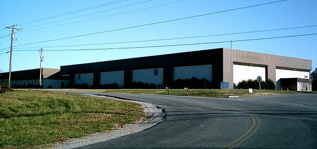
Property Record
2127 Burton Branch Rd, Cookeville, TN 38506
NEARBY LISTINGS FOR SALE OR LEASE
Property Detail
2127 Burton Branch Rd
Cookeville, TN
Putnam
041-084.00-004
Tennessee
Warehouse
46 AC
X
Tennessee Central Area
47133C0290B
Other Market Areas
50,400 SF
DEMOGRAPHICS near 2127 Burton Branch Rd
1 Mile
3 Mile
5 Mile
2024 Total Population
3,677
26,411
48,088
2029 Population
3,958
28,409
51,720
Pop Growth 2024-2029
+ 7.64%
+ 7.57%
+ 7.55%
Average Age
40
38
38
2024 Total Households
1,581
10,938
19,860
HH Growth 2024-2029
+ 8.03%
+ 8.13%
+ 8.12%
Median Household Inc
$54,677
$48,009
$48,353
Avg Household Size
2.30
2.30
2.30
2024 Avg HH Vehicles
2.00
2.00
2.00
Median Home Value
$198,792
$227,168
$225,936
Median Year Built
1987
1985
1987
Nearby Places
Map Layers
Map Styles
 Street
 Aerial
- Restaurants
- Banks
- Shops
- Fitness
- Groceries
SALE & LEASE HISTORY
LISTING DATE
SALE/LEASE

Sep 25, 2016
For Lease
Nearby Properties
Address
Land Use
TOTAL SIZE
Lot Size
Zoning
Address
Land Use
TOTAL SIZE
Lot Size
Zoning
463,845 SF
38 AC
LM
Address
Land Use
TOTAL SIZE
Lot Size
Zoning
26,100 SF
19.90 AC
CM
Address
Land Use
TOTAL SIZE
Lot Size
Zoning
58,980 SF
6.74 AC
PCD
Address
Land Use
TOTAL SIZE
Lot Size
Zoning
50,012 SF
9.61 AC
C3
Address
Land Use
TOTAL SIZE
Lot Size
Zoning
17,256 SF
8.33 AC
Address
Land Use
TOTAL SIZE
Lot Size
Zoning
211,289 SF
25.69 AC
Address
Land Use
TOTAL SIZE
Lot Size
Zoning
34,120 SF
1.60 AC
BD
Address
Land Use
TOTAL SIZE
Lot Size
Zoning
2,024 SF
8.90 AC
C04
Address
Land Use
TOTAL SIZE
Lot Size
Zoning
14,892 SF
8 AC
R3
Address
Land Use
TOTAL SIZE
Lot Size
Zoning
9,250 SF
3.05 AC
C2
Address
Land Use
TOTAL SIZE
Lot Size
Zoning
4,135 SF
20 AC
R4
Address
Land Use
TOTAL SIZE
Lot Size
Zoning
89,412 SF
13.10 AC
PCD
Address
Land Use
TOTAL SIZE
Lot Size
Zoning
33,120 SF
5.97 AC
Address
Land Use
TOTAL SIZE
Lot Size
Zoning
3,500 SF
8.19 AC
PRD
Address
Land Use
TOTAL SIZE
Lot Size
Zoning
1,934 SF
8.80 AC
Address
Land Use
TOTAL SIZE
Lot Size
Zoning
27,825 SF
2.07 AC
Address
Land Use
TOTAL SIZE
Lot Size
Zoning
8,176 SF
3.67 AC
PRD
Address
Land Use
TOTAL SIZE
Lot Size
Zoning
54,019 SF
9.18 AC
Address
Land Use
TOTAL SIZE
Lot Size
Zoning
12,054 SF
0.77 AC
CM
Address
Land Use
TOTAL SIZE
Lot Size
Zoning
36,871 SF
2.82 AC
C3
Address
Land Use
TOTAL SIZE
Lot Size
Zoning
67,680 SF
6.93 AC
Address
Land Use
TOTAL SIZE
Lot Size
Zoning
51,356 SF
8.99 AC
Address
Land Use
TOTAL SIZE
Lot Size
Zoning
36,135 SF
2.80 AC
Address
Land Use
TOTAL SIZE
Lot Size
Zoning
9,860 SF
14.50 AC
Address
Land Use
TOTAL SIZE
Lot Size
Zoning
30,064 SF
0.98 AC
C2
Address
Land Use
TOTAL SIZE
Lot Size
Zoning
22,112 SF
1.20 AC
C2
Address
Land Use
TOTAL SIZE
Lot Size
Zoning
4,256 SF
4.28 AC
Address
Land Use
TOTAL SIZE
Lot Size
Zoning
18,118 SF
7.44 AC
Address
Land Use
TOTAL SIZE
Lot Size
Zoning
7,512 SF
5.60 AC
Address
Land Use
TOTAL SIZE
Lot Size
Zoning
19,680 SF
0.94 AC
CBD
The World's #1 Commercial Real Estate Marketplace
Connect with us
© 2026 CoStar Group
The information above has been obtained from sources believed reliable. While we do not doubt its accuracy we have not verified it and make no guarantee, warranty or representation about it. It is your responsibility to independently confirm its accuracy and completeness. Any projections, opinions, assumptions, or estimates used are for example only and do not represent the current or future performance of the property. The value of this transaction to you depends on tax and other factors which should be evaluated by your tax, financial, and legal advisors. You and your advisors should conduct a careful, independent investigation of the property to determine to your satisfaction the suitability of the property for your needs.