Property Record
2127 New Holland Pike, Lancaster, PA 17601
Current Lease Availabilities
NEARBY LISTINGS FOR SALE OR LEASE
Property Detail
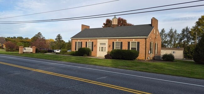
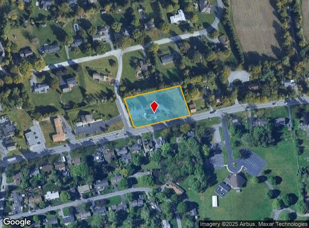
2127 New Holland Pike
Lancaster, PA
Gable Park Woods Sec 01-B
310-55575-0-0000
2127 NEW HOLLAND PIKE
Officebuilding
Lancaster
X
Pennsylvania
42071C0378F
18
2024
1.50 AC
2025
Lancaster County
013203
Philadelphia
1,920 SF
DEMOGRAPHICS near 2127 New Holland Pike
1 Mile
3 Mile
5 Mile
2024 Total Population
3,275
34,552
139,804
2029 Population
3,309
34,701
141,028
Pop Growth 2024-2029
+ 1.04%
+ 0.43%
+ 0.88%
Average Age
42
42
40
2024 Total Households
1,144
13,377
52,297
HH Growth 2024-2029
+ 1.05%
+ 0.39%
+ 0.91%
Median Household Inc
$98,935
$85,821
$73,653
Avg Household Size
2.80
2.50
2.50
2024 Avg HH Vehicles
2.00
2.00
2.00
Median Home Value
$362,230
$285,771
$259,868
Median Year Built
1974
1975
1967
Nearby Places
- Restaurants
- Banks
- Shops
- Fitness
- Groceries
PUBLIC TRANSPORTATION
COMMUTER RAIL
DRIVE
WALK
Distance
11 min
4.5 mi
AIRPORT
Harrisburg International
DRIVE
WALK
Distance
Harrisburg International
45 min
34.6 mi
Freight Ports
Port Newark Container Terminal
DRIVE
WALK
Distance
Port Newark Container Terminal
82 min
48.8 mi
Nearby Properties
Address
Land Use
TOTAL SIZE
Lot Size
Zoning
Address
Land Use
TOTAL SIZE
Lot Size
Zoning
740,990 SF
106.29 AC
Address
Land Use
TOTAL SIZE
Lot Size
Zoning
403,771 SF
106.93 AC
Address
Land Use
TOTAL SIZE
Lot Size
Zoning
678,995 SF
96.17 AC
Address
Land Use
TOTAL SIZE
Lot Size
Zoning
419,136 SF
34.11 AC
Address
Land Use
TOTAL SIZE
Lot Size
Zoning
333,301 SF
24.15 AC
MU
Address
Land Use
TOTAL SIZE
Lot Size
Zoning
275,959 SF
68.50 AC
IN
Address
Land Use
TOTAL SIZE
Lot Size
Zoning
233,738 SF
34.10 AC
Address
Land Use
TOTAL SIZE
Lot Size
Zoning
354,921 SF
6.36 AC
Address
Land Use
TOTAL SIZE
Lot Size
Zoning
203,415 SF
10.74 AC
Address
Land Use
TOTAL SIZE
Lot Size
Zoning
254,079 SF
21.54 AC
Address
Land Use
TOTAL SIZE
Lot Size
Zoning
21.41 AC
Address
Land Use
TOTAL SIZE
Lot Size
Zoning
246,742 SF
12.49 AC
B-4
Address
Land Use
TOTAL SIZE
Lot Size
Zoning
125,073 SF
19.07 AC
I
Address
Land Use
TOTAL SIZE
Lot Size
Zoning
302,460 SF
51.80 AC
R4
Address
Land Use
TOTAL SIZE
Lot Size
Zoning
123,445 SF
13.66 AC
I
Address
Land Use
TOTAL SIZE
Lot Size
Zoning
198,492 SF
24.74 AC
R-2
Address
Land Use
TOTAL SIZE
Lot Size
Zoning
844,700 SF
59.50 AC
I
Address
Land Use
TOTAL SIZE
Lot Size
Zoning
63,514 SF
177.90 AC
R-1
Address
Land Use
TOTAL SIZE
Lot Size
Zoning
1,137,774 SF
54.21 AC
SM
Address
Land Use
TOTAL SIZE
Lot Size
Zoning
1,042,820 SF
74.80 AC
CM
Address
Land Use
TOTAL SIZE
Lot Size
Zoning
137,933 SF
16.11 AC
Address
Land Use
TOTAL SIZE
Lot Size
Zoning
111,896 SF
8.30 AC
Address
Land Use
TOTAL SIZE
Lot Size
Zoning
119,442 SF
79.40 AC
PO
Address
Land Use
TOTAL SIZE
Lot Size
Zoning
19.29 AC
Address
Land Use
TOTAL SIZE
Lot Size
Zoning
258,104 SF
31.40 AC
I
Address
Land Use
TOTAL SIZE
Lot Size
Zoning
83,728 SF
2.70 AC
C-2
Address
Land Use
TOTAL SIZE
Lot Size
Zoning
128,516 SF
20.40 AC
R2
Address
Land Use
TOTAL SIZE
Lot Size
Zoning
251,531 SF
42.54 AC
Address
Land Use
TOTAL SIZE
Lot Size
Zoning
139,052 SF
4.86 AC
R-3
Address
Land Use
TOTAL SIZE
Lot Size
Zoning
79,137 SF
7.99 AC
IN
The World's #1 Commercial Real Estate Marketplace
Connect with us
© 2025 CoStar Group
The information above has been obtained from sources believed reliable. While we do not doubt its accuracy we have not verified it and make no guarantee, warranty or representation about it. It is your responsibility to independently confirm its accuracy and completeness. Any projections, opinions, assumptions, or estimates used are for example only and do not represent the current or future performance of the property. The value of this transaction to you depends on tax and other factors which should be evaluated by your tax, financial, and legal advisors. You and your advisors should conduct a careful, independent investigation of the property to determine to your satisfaction the suitability of the property for your needs.