Property Record
21271 Smith Switch Rd, Ashburn, VA 20147
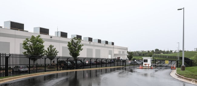

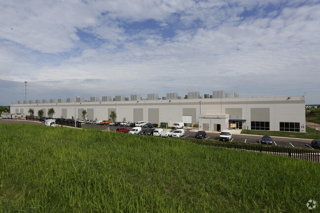
Property Detail
21271 Smith Switch Rd
060-48-5060
ASHBURN VILLAGE SEC.69 202012230127119 AGREE, 201402060006158P/9 ST DEDD 201104060022106P, 200708310064403
Datacentre
LOUDOUN
PDH4
Virginia
AE The base floodplain where base flood elevations are provided. AE Zones are now used on new format FIRMs instead of A1-A30 Zones.
34.74 AC
2025
Rt 28/Dulles North
2025
Washington, DC
611018
Washington-Arlington-Alexandria, DC-VA-MD-WV
429,711 SF
NEARBY LISTINGS FOR SALE OR LEASE
DEMOGRAPHICS near 21271 Smith Switch Rd
1 mile
3 mile
5 mile
2025 Total Population
10,586
90,454
213,507
2030 Population
10,940
94,496
221,577
Pop Growth 2025-2030
+ 3.34%
+ 4.47%
+ 3.78%
Average Age
49
39
39
2025 Total Households
4,482
33,382
72,797
HH Growth 2025-2030
+ 3.90%
+ 4.64%
+ 3.97%
Median Household Inc
$128,375
$145,925
$160,127
Avg Household Size
2.30
2.70
2.90
2025 Avg HH Vehicles
2.00
2.00
2.00
Median Home Value
$689,897
$690,770
$697,841
Median Year Built
2005
1999
1998
Nearby Places
Map Layers
Map Styles
 Street
 Aerial
Layers
 Traffic
 Biking
Places
Listings with unknown addresses are not visible on the map
- Restaurants
- Banks
- Shops
- Fitness
- Groceries
PUBLIC TRANSPORTATION
AIRPORT
Washington Dulles International
Drive
Walk
Distance
Washington Dulles International
17 min
8.1 mi
Ronald Reagan Washington Ntl
Drive
Walk
Distance
Ronald Reagan Washington Ntl
49 min
30.9 mi
Freight Ports
Port of Baltimore
Drive
Walk
Distance
Port of Baltimore
89 min
63.0 mi
Nearby Properties
Address
Land Use
TOTAL SIZE
Lot Size
Zoning
Address
Land Use
TOTAL SIZE
Lot Size
Zoning
1,137,740 SF
38.21 AC
PDOP
Address
Land Use
TOTAL SIZE
Lot Size
Zoning
438,460 SF
10.85 AC
OP
Address
Land Use
TOTAL SIZE
Lot Size
Zoning
518,449 SF
32.11 AC
IP
Address
Land Use
TOTAL SIZE
Lot Size
Zoning
462,210 SF
PDOP
Address
Land Use
TOTAL SIZE
Lot Size
Zoning
521,784 SF
PDOP
Address
Land Use
TOTAL SIZE
Lot Size
Zoning
650,346 SF
PDMUB
Address
Land Use
TOTAL SIZE
Lot Size
Zoning
800,702 SF
111.70 AC
PDIP
Address
Land Use
TOTAL SIZE
Lot Size
Zoning
1,434,706 SF
30.91 AC
PDRDP
Address
Land Use
TOTAL SIZE
Lot Size
Zoning
789,350 SF
31.73 AC
PDOP
Address
Land Use
TOTAL SIZE
Lot Size
Zoning
446,512 SF
25.41 AC
IP
Address
Land Use
TOTAL SIZE
Lot Size
Zoning
368,624 SF
8.85 AC
PDOP
Address
Land Use
TOTAL SIZE
Lot Size
Zoning
234,124 SF
23.84 AC
PDOP
Address
Land Use
TOTAL SIZE
Lot Size
Zoning
672,272 SF
44.53 AC
PDIP
Address
Land Use
TOTAL SIZE
Lot Size
Zoning
679,455 SF
31.97 AC
PDIP
Address
Land Use
TOTAL SIZE
Lot Size
Zoning
427,320 SF
16.33 AC
PDIP
Address
Land Use
TOTAL SIZE
Lot Size
Zoning
2,735,138 SF
123.03 AC
PDAAAR
Address
Land Use
TOTAL SIZE
Lot Size
Zoning
364,600 SF
PDOP
Address
Land Use
TOTAL SIZE
Lot Size
Zoning
302,180 SF
10.92 AC
PDOP
Address
Land Use
TOTAL SIZE
Lot Size
Zoning
310,717 SF
14.30 AC
PDOP
Address
Land Use
TOTAL SIZE
Lot Size
Zoning
288,403 SF
16.56 AC
PDOP
Address
Land Use
TOTAL SIZE
Lot Size
Zoning
286,865 SF
18.56 AC
IP
Address
Land Use
TOTAL SIZE
Lot Size
Zoning
493,504 SF
15.73 AC
PDOP
Address
Land Use
TOTAL SIZE
Lot Size
Zoning
286,800 SF
10.97 AC
IP
Address
Land Use
TOTAL SIZE
Lot Size
Zoning
308,630 SF
14.44 AC
PDIP
Address
Land Use
TOTAL SIZE
Lot Size
Zoning
565,680 SF
18.44 AC
PDIP
Address
Land Use
TOTAL SIZE
Lot Size
Zoning
228,606 SF
PDOP
Address
Land Use
TOTAL SIZE
Lot Size
Zoning
1,434,706 SF
96.74 AC
PDRDP
Address
Land Use
TOTAL SIZE
Lot Size
Zoning
455,793 SF
22.60 AC
IP
Address
Land Use
TOTAL SIZE
Lot Size
Zoning
180,355 SF
12.89 AC
PDIP
Address
Land Use
TOTAL SIZE
Lot Size
Zoning
362,108 SF
18.82 AC
PDOP
The World's #1 Commercial Real Estate Marketplace
Connect with us
© 2026 CoStar Group
The information above has been obtained from sources believed reliable. While we do not doubt its accuracy we have not verified it and make no guarantee, warranty or representation about it. It is your responsibility to independently confirm its accuracy and completeness. Any projections, opinions, assumptions, or estimates used are for example only and do not represent the current or future performance of the property. The value of this transaction to you depends on tax and other factors which should be evaluated by your tax, financial, and legal advisors. You and your advisors should conduct a careful, independent investigation of the property to determine to your satisfaction the suitability of the property for your needs.