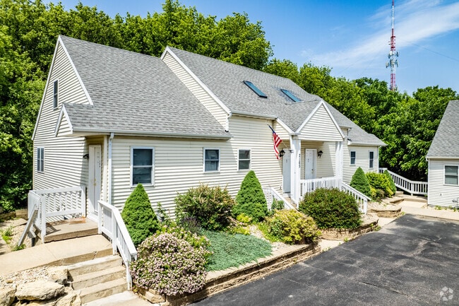
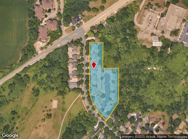
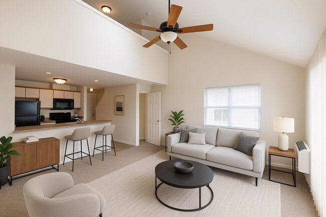
Property Record
2129 Muir Field Rd, Madison, WI 53719
NEARBY LISTINGS FOR SALE OR LEASE
Property Detail
2129 Muir Field Rd
Madison, WI
Meadowoods Sky View Meadows
0608-021-1003-5
MEADOWOODS SKY VIEW MEADOWS, LOTS 47 & PRT OF LOT 48 DESC AS FOL: BEG SE COR SD LOT 48, TH N 00 DEG 04 MIN 10 SEC E 125 FT, TH S 88 DEG 39 MIN 37 SEC W 150 FT, TH S 00 DEG 04 MIN 10 SEC W 143.38 FT, TH N 81 DEG 41 MIN 53 SEC E 151.57 FT TO POB. ALSO,
Commercialnec
Dane
X
Wisconsin
55025C0394G
47,48
2024
3.17 AC
2024
West Madison
000504
Milwaukee/Madison
25,219 SF
DEMOGRAPHICS near 2129 Muir Field Rd
1 Mile
3 Mile
5 Mile
2024 Total Population
14,084
78,481
163,960
2029 Population
14,557
81,744
170,401
Pop Growth 2024-2029
+ 3.36%
+ 4.16%
+ 3.93%
Average Age
36
38
39
2024 Total Households
5,844
34,663
72,380
HH Growth 2024-2029
+ 3.49%
+ 4.39%
+ 4.05%
Median Household Inc
$90,660
$85,715
$89,890
Avg Household Size
2.30
2.20
2.20
2024 Avg HH Vehicles
2.00
2.00
2.00
Median Home Value
$301,835
$342,041
$376,569
Median Year Built
1991
1992
1988
Nearby Places
Map Layers
Map Styles
 Street
 Aerial
- Restaurants
- Banks
- Shops
- Fitness
- Groceries
PUBLIC TRANSPORTATION
AIRPORT
Dane County Regional/Truax Field
DRIVE
WALK
Distance
Dane County Regional/Truax Field
28 min
12.8 mi
Freight Ports
Port Milwaukee
DRIVE
WALK
Distance
Port Milwaukee
109 min
89.5 mi
Nearby Properties
Address
Land Use
TOTAL SIZE
Lot Size
Zoning
Address
Land Use
TOTAL SIZE
Lot Size
Zoning
82,796 SF
9.26 AC
SE
Address
Land Use
TOTAL SIZE
Lot Size
Zoning
69,336 SF
26.90 AC
SE
Address
Land Use
TOTAL SIZE
Lot Size
Zoning
354,461 SF
37.40 AC
RMX
Address
Land Use
TOTAL SIZE
Lot Size
Zoning
700,496 SF
23.94 AC
SR-V2
Address
Land Use
TOTAL SIZE
Lot Size
Zoning
56,000 SF
23.87 AC
SE
Address
Land Use
TOTAL SIZE
Lot Size
Zoning
89.21 AC
Address
Land Use
TOTAL SIZE
Lot Size
Zoning
16.45 AC
Address
Land Use
TOTAL SIZE
Lot Size
Zoning
1.44 AC
TE
Address
Land Use
TOTAL SIZE
Lot Size
Zoning
77,296 SF
4.84 AC
TR-U1
Address
Land Use
TOTAL SIZE
Lot Size
Zoning
11.20 AC
SE
Address
Land Use
TOTAL SIZE
Lot Size
Zoning
51,205 SF
9.32 AC
SE
Address
Land Use
TOTAL SIZE
Lot Size
Zoning
27,201 SF
7.65 AC
TR-U2
Address
Land Use
TOTAL SIZE
Lot Size
Zoning
27,201 SF
10.08 AC
TR-U2
Address
Land Use
TOTAL SIZE
Lot Size
Zoning
161,767 SF
4.58 AC
CC-T
Address
Land Use
TOTAL SIZE
Lot Size
Zoning
2.91 AC
SE
Address
Land Use
TOTAL SIZE
Lot Size
Zoning
290,535 SF
11.25 AC
PD
Address
Land Use
TOTAL SIZE
Lot Size
Zoning
4.05 AC
CC-T
Address
Land Use
TOTAL SIZE
Lot Size
Zoning
311,672 SF
4.59 AC
PD
Address
Land Use
TOTAL SIZE
Lot Size
Zoning
254,922 SF
11.97 AC
PD
Address
Land Use
TOTAL SIZE
Lot Size
Zoning
17.80 AC
Address
Land Use
TOTAL SIZE
Lot Size
Zoning
324,920 SF
8.47 AC
PD
Address
Land Use
TOTAL SIZE
Lot Size
Zoning
229,381 SF
7.35 AC
PD
Address
Land Use
TOTAL SIZE
Lot Size
Zoning
6.57 AC
SR-V2
Address
Land Use
TOTAL SIZE
Lot Size
Zoning
13.98 AC
Address
Land Use
TOTAL SIZE
Lot Size
Zoning
237,225 SF
1.84 AC
PD
Address
Land Use
TOTAL SIZE
Lot Size
Zoning
Address
Land Use
TOTAL SIZE
Lot Size
Zoning
2.98 AC
TR-U2
Address
Land Use
TOTAL SIZE
Lot Size
Zoning
8.10 AC
Address
Land Use
TOTAL SIZE
Lot Size
Zoning
244,074 SF
7.96 AC
SR-V2
Address
Land Use
TOTAL SIZE
Lot Size
Zoning
34,457 SF
9.04 AC
PD
The World's #1 Commercial Real Estate Marketplace
Connect with us
© 2025 CoStar Group
The information above has been obtained from sources believed reliable. While we do not doubt its accuracy we have not verified it and make no guarantee, warranty or representation about it. It is your responsibility to independently confirm its accuracy and completeness. Any projections, opinions, assumptions, or estimates used are for example only and do not represent the current or future performance of the property. The value of this transaction to you depends on tax and other factors which should be evaluated by your tax, financial, and legal advisors. You and your advisors should conduct a careful, independent investigation of the property to determine to your satisfaction the suitability of the property for your needs.