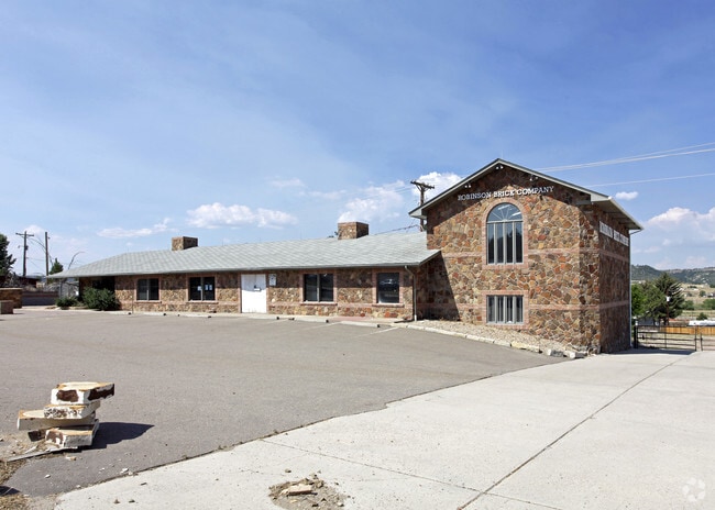
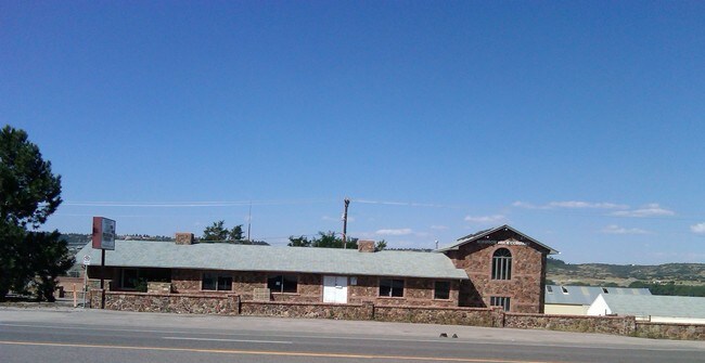
Property Record
2129 N State Highway 83, Franktown, CO 80116

Save to a Folder
{{folder.Name}}
{{folder.ListingIds.length}} Properties
{{folder.ListingIds.length}} Property
Create a New Folder
Property Detail
2129 N State Highway 83
2349-353-00-010
TR IN SW1/4SW1/4 35-7-66 2.49 AM/L LSP 3263 & 4613
Officebuilding
Douglas
C
Colorado
B and X Area of moderate flood hazard, usually the area between the limits of the 100-year and 500-year floods.
2.49 AC
2024
Southeast
2026
Denver
013909
Denver-Aurora-Centennial, CO
18,031 SF
NEARBY LISTINGS FOR SALE OR LEASE
-
-
View all Franktown listings for sale on LoopNet.com
DEMOGRAPHICS near 2129 N State Highway 83
1 mile
3 mile
5 mile
2025 Total Population
484
9,365
46,689
2030 Population
524
10,225
50,829
Pop Growth 2025-2030
+ 8.26%
+ 9.18%
+ 8.87%
Average Age
41
38
40
2025 Total Households
166
2,998
15,542
HH Growth 2025-2030
+ 8.43%
+ 9.37%
+ 8.96%
Median Household Inc
$145,138
$166,164
$163,694
Avg Household Size
2.90
3.10
3.00
2025 Avg HH Vehicles
3.00
3.00
3.00
Median Home Value
$807,228
$765,593
$777,945
Median Year Built
2001
2009
2003
Nearby Places
Map Layers
Map Styles
 Street
 Aerial
Layers
 Traffic
 Biking
Places
Listings with unknown addresses are not visible on the map
- Restaurants
- Banks
- Shops
- Fitness
- Groceries
Nearby Properties
Address
Land Use
TOTAL SIZE
Lot Size
Zoning
Address
Land Use
TOTAL SIZE
Lot Size
Zoning
132,414 SF
25 AC
Address
Land Use
TOTAL SIZE
Lot Size
Zoning
126,826 SF
23.30 AC
PDU
Address
Land Use
TOTAL SIZE
Lot Size
Zoning
56,566 SF
11.37 AC
Address
Land Use
TOTAL SIZE
Lot Size
Zoning
258,822 SF
62.72 AC
PDU
Address
Land Use
TOTAL SIZE
Lot Size
Zoning
26,860 SF
4.83 AC
RR
Address
Land Use
TOTAL SIZE
Lot Size
Zoning
2,847 SF
573.91 AC
A1
Address
Land Use
TOTAL SIZE
Lot Size
Zoning
12,431 SF
20.47 AC
Address
Land Use
TOTAL SIZE
Lot Size
Zoning
25,972 SF
2.20 AC
GI
Address
Land Use
TOTAL SIZE
Lot Size
Zoning
35,915 SF
23 AC
A1
Address
Land Use
TOTAL SIZE
Lot Size
Zoning
1,982 SF
3.45 AC
Address
Land Use
TOTAL SIZE
Lot Size
Zoning
276.37 AC
PDU
Address
Land Use
TOTAL SIZE
Lot Size
Zoning
5,367 SF
168.53 AC
Address
Land Use
TOTAL SIZE
Lot Size
Zoning
625 SF
82.02 AC
PDU
Address
Land Use
TOTAL SIZE
Lot Size
Zoning
16,664 SF
15.57 AC
RR
Address
Land Use
TOTAL SIZE
Lot Size
Zoning
23,849 SF
34.55 AC
RR
Address
Land Use
TOTAL SIZE
Lot Size
Zoning
8,640 SF
2.49 AC
Address
Land Use
TOTAL SIZE
Lot Size
Zoning
2,400 SF
3.56 AC
C
Address
Land Use
TOTAL SIZE
Lot Size
Zoning
21,450 SF
2.42 AC
Address
Land Use
TOTAL SIZE
Lot Size
Zoning
21,888 SF
9.25 AC
Address
Land Use
TOTAL SIZE
Lot Size
Zoning
14,698 SF
5 AC
C
Address
Land Use
TOTAL SIZE
Lot Size
Zoning
1,281 SF
39.91 AC
Address
Land Use
TOTAL SIZE
Lot Size
Zoning
11,950 SF
5.56 AC
C
Address
Land Use
TOTAL SIZE
Lot Size
Zoning
12,080 SF
5.29 AC
RR
Address
Land Use
TOTAL SIZE
Lot Size
Zoning
14,447 SF
1.61 AC
C
Address
Land Use
TOTAL SIZE
Lot Size
Zoning
6,372 SF
1.59 AC
C
Address
Land Use
TOTAL SIZE
Lot Size
Zoning
85.86 AC
PDU
Address
Land Use
TOTAL SIZE
Lot Size
Zoning
5,950 SF
1.43 AC
C
The World's #1 Commercial Real Estate Marketplace
Connect with us
© 2026 CoStar Group
The information above has been obtained from sources believed reliable. While we do not doubt its accuracy we have not verified it and make no guarantee, warranty or representation about it. It is your responsibility to independently confirm its accuracy and completeness. Any projections, opinions, assumptions, or estimates used are for example only and do not represent the current or future performance of the property. The value of this transaction to you depends on tax and other factors which should be evaluated by your tax, financial, and legal advisors. You and your advisors should conduct a careful, independent investigation of the property to determine to your satisfaction the suitability of the property for your needs.