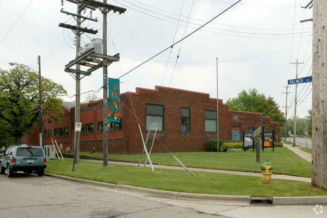
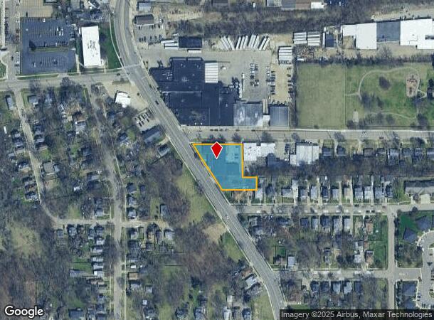
Property Record
2129 Portage St, Kalamazoo, MI 49001

NEARBY LISTINGS FOR SALE OR LEASE
Property Detail
2129 Portage St
Kalamazoo-Portage, MI
Rose Hill
06-27-283-100
COMMENCING ON THE EAST LINE OF PORTAGE STREET AT THE NORTHWEST CORNER OF THE ROSE HILL PLAT; THENCE NORTHWESTERLY 162.7FT ON
Industrialgeneral
Kalamazoo
X
Michigan
26077C0189E
1
2024
0.70 AC
2025
Southern Kalamazoo County
001001
West Michigan
11,754 SF
DEMOGRAPHICS near 2129 Portage St
1 Mile
3 Mile
5 Mile
2024 Total Population
14,393
72,962
151,998
2029 Population
14,441
73,202
152,015
Pop Growth 2024-2029
+ 0.33%
+ 0.33%
+ 0.01%
Average Age
36
35
36
2024 Total Households
5,675
28,985
63,973
HH Growth 2024-2029
+ 0.39%
+ 0.37%
+ 0.01%
Median Household Inc
$51,210
$47,049
$50,279
Avg Household Size
2.40
2.20
2.20
2024 Avg HH Vehicles
2.00
2.00
2.00
Median Home Value
$127,372
$142,275
$163,459
Median Year Built
1947
1953
1968
Nearby Places
Map Layers
Map Styles
 Street
 Aerial
- Restaurants
- Banks
- Shops
- Fitness
- Groceries
PUBLIC TRANSPORTATION
COMMUTER RAIL
DRIVE
WALK
Distance
6 min
2.1 mi
AIRPORT
Kalamazoo/Battle Creek International
DRIVE
WALK
Distance
Kalamazoo/Battle Creek International
12 min
3.4 mi
Nearby Properties
Address
Land Use
TOTAL SIZE
Lot Size
Zoning
Address
Land Use
TOTAL SIZE
Lot Size
Zoning
632,218 SF
10.84 AC
M-1
Address
Land Use
TOTAL SIZE
Lot Size
Zoning
374,906 SF
16.31 AC
RM-36
Address
Land Use
TOTAL SIZE
Lot Size
Zoning
329,276 SF
43.86 AC
RM-1
Address
Land Use
TOTAL SIZE
Lot Size
Zoning
429,500 SF
2 AC
CCBD
Address
Land Use
TOTAL SIZE
Lot Size
Zoning
877,422 SF
38.18 AC
M-2
Address
Land Use
TOTAL SIZE
Lot Size
Zoning
201,940 SF
9.30 AC
RM-36
Address
Land Use
TOTAL SIZE
Lot Size
Zoning
255,452 SF
20.57 AC
Address
Land Use
TOTAL SIZE
Lot Size
Zoning
110,686 SF
9.45 AC
CCBD
Address
Land Use
TOTAL SIZE
Lot Size
Zoning
5.04 AC
CPD
Address
Land Use
TOTAL SIZE
Lot Size
Zoning
134,876 SF
16.45 AC
RM-15
Address
Land Use
TOTAL SIZE
Lot Size
Zoning
275,595 SF
0.65 AC
CCBD
Address
Land Use
TOTAL SIZE
Lot Size
Zoning
35.87 AC
I-1
Address
Land Use
TOTAL SIZE
Lot Size
Zoning
Address
Land Use
TOTAL SIZE
Lot Size
Zoning
50,826 SF
0.79 AC
CCBD
Address
Land Use
TOTAL SIZE
Lot Size
Zoning
17,858 SF
15.27 AC
RM-1
Address
Land Use
TOTAL SIZE
Lot Size
Zoning
498,424 SF
41.72 AC
M-2
Address
Land Use
TOTAL SIZE
Lot Size
Zoning
228,368 SF
9.60 AC
PUD
Address
Land Use
TOTAL SIZE
Lot Size
Zoning
606,439 SF
34.61 AC
M-2
Address
Land Use
TOTAL SIZE
Lot Size
Zoning
274,412 SF
12.10 AC
RM-1
Address
Land Use
TOTAL SIZE
Lot Size
Zoning
2.31 AC
CPD
Address
Land Use
TOTAL SIZE
Lot Size
Zoning
80,064 SF
6.13 AC
M-1
Address
Land Use
TOTAL SIZE
Lot Size
Zoning
216,427 SF
18.83 AC
B-2
Address
Land Use
TOTAL SIZE
Lot Size
Zoning
4.65 AC
CPD
Address
Land Use
TOTAL SIZE
Lot Size
Zoning
31.79 AC
I-1
Address
Land Use
TOTAL SIZE
Lot Size
Zoning
157,123 SF
M
Address
Land Use
TOTAL SIZE
Lot Size
Zoning
793,429 SF
36.48 AC
M
Address
Land Use
TOTAL SIZE
Lot Size
Zoning
133,976 SF
15.04 AC
CPD
Address
Land Use
TOTAL SIZE
Lot Size
Zoning
393,522 SF
33.31 AC
M-2
Address
Land Use
TOTAL SIZE
Lot Size
Zoning
99,092 SF
1.45 AC
CCBD
Address
Land Use
TOTAL SIZE
Lot Size
Zoning
25,000 SF
5.63 AC
B-3
The World's #1 Commercial Real Estate Marketplace
Connect with us
© 2025 CoStar Group
The information above has been obtained from sources believed reliable. While we do not doubt its accuracy we have not verified it and make no guarantee, warranty or representation about it. It is your responsibility to independently confirm its accuracy and completeness. Any projections, opinions, assumptions, or estimates used are for example only and do not represent the current or future performance of the property. The value of this transaction to you depends on tax and other factors which should be evaluated by your tax, financial, and legal advisors. You and your advisors should conduct a careful, independent investigation of the property to determine to your satisfaction the suitability of the property for your needs.