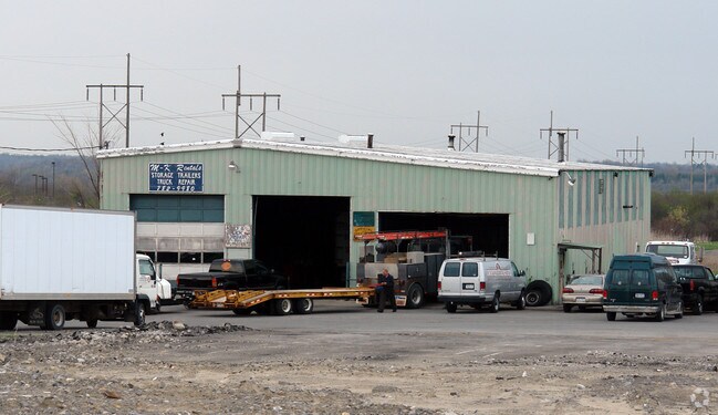
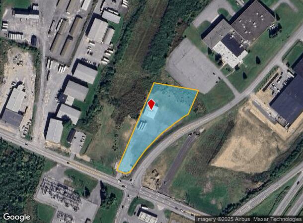
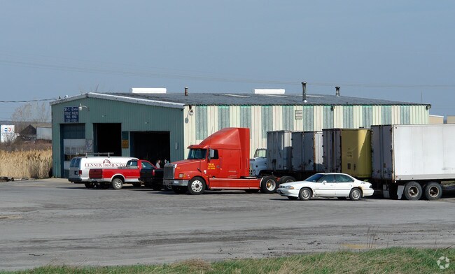
Property Record
21291 State Route 12F, Watertown, NY 13601
NEARBY LISTINGS FOR SALE OR LEASE
Property Detail
21291 State Route 12F
225800-082-008-0001-002-000
Jefferson
Warehouse
New York
ARE
2.000
36045C0727G
2.10 AC
2025
Jefferson County
2024
Syracuse
062100
Watertown-Fort Drum, NY
4,672 SF
DEMOGRAPHICS near 21291 State Route 12F
1 Mile
3 Mile
5 Mile
2024 Total Population
1,830
25,159
35,310
2029 Population
1,825
24,815
34,723
Pop Growth 2024-2029
(0.27%)
(1.37%)
(1.66%)
Average Age
34
38
38
2024 Total Households
750
11,158
15,039
HH Growth 2024-2029
(0.67%)
(1.63%)
(1.93%)
Median Household Inc
$56,238
$52,976
$55,026
Avg Household Size
2.30
2.10
2.20
2024 Avg HH Vehicles
1.00
1.00
1.00
Median Home Value
$186,470
$155,268
$160,009
Median Year Built
1984
1949
1954
Nearby Places
- Restaurants
- Banks
- Shops
- Fitness
- Groceries
SALE & LEASE HISTORY
LISTING DATE
SALE/LEASE

Dec 28, 2016
For Sale
Nearby Properties
Address
Land Use
TOTAL SIZE
Lot Size
Zoning
Address
Land Use
TOTAL SIZE
Lot Size
Zoning
242,869 SF
8.06 AC
PC
Address
Land Use
TOTAL SIZE
Lot Size
Zoning
Address
Land Use
TOTAL SIZE
Lot Size
Zoning
11,303 SF
49.20 AC
O
Address
Land Use
TOTAL SIZE
Lot Size
Zoning
18,042 SF
22.50 AC
PARK
Address
Land Use
TOTAL SIZE
Lot Size
Zoning
5,568 SF
95 AC
PC
Address
Land Use
TOTAL SIZE
Lot Size
Zoning
160,819 SF
8.70 AC
PC
Address
Land Use
TOTAL SIZE
Lot Size
Zoning
158,186 SF
3.36 AC
PC
Address
Land Use
TOTAL SIZE
Lot Size
Zoning
381,570 SF
3.30 AC
DC
Address
Land Use
TOTAL SIZE
Lot Size
Zoning
215,473 SF
82.50 AC
PC
Address
Land Use
TOTAL SIZE
Lot Size
Zoning
746,745 SF
72.40 AC
C
Address
Land Use
TOTAL SIZE
Lot Size
Zoning
115,362 SF
12.39 AC
INDUST
Address
Land Use
TOTAL SIZE
Lot Size
Zoning
52,650 SF
6.50 AC
PC
Address
Land Use
TOTAL SIZE
Lot Size
Zoning
106,141 SF
25.70 AC
C
Address
Land Use
TOTAL SIZE
Lot Size
Zoning
79,220 SF
0.47 AC
DC
Address
Land Use
TOTAL SIZE
Lot Size
Zoning
88.41 AC
B
Address
Land Use
TOTAL SIZE
Lot Size
Zoning
14,752 SF
32.36 AC
99
Address
Land Use
TOTAL SIZE
Lot Size
Zoning
27,296 SF
81.58 AC
99
Address
Land Use
TOTAL SIZE
Lot Size
Zoning
74,565 SF
2.50 AC
DC
Address
Land Use
TOTAL SIZE
Lot Size
Zoning
4,744 SF
40.87 AC
PC
Address
Land Use
TOTAL SIZE
Lot Size
Zoning
32.73 AC
B
Address
Land Use
TOTAL SIZE
Lot Size
Zoning
176,409 SF
1.99 AC
PC
Address
Land Use
TOTAL SIZE
Lot Size
Zoning
0.33 AC
DC
Address
Land Use
TOTAL SIZE
Lot Size
Zoning
83,776 SF
9.50 AC
C
Address
Land Use
TOTAL SIZE
Lot Size
Zoning
154,241 SF
13.06 AC
C
Address
Land Use
TOTAL SIZE
Lot Size
Zoning
7,616 SF
16 AC
PC
Address
Land Use
TOTAL SIZE
Lot Size
Zoning
59,771 SF
9.68 AC
PARK
Address
Land Use
TOTAL SIZE
Lot Size
Zoning
10,559 SF
1.11 AC
99
Address
Land Use
TOTAL SIZE
Lot Size
Zoning
134,480 SF
21.36 AC
99
Address
Land Use
TOTAL SIZE
Lot Size
Zoning
87,912 SF
88.80 AC
C
Address
Land Use
TOTAL SIZE
Lot Size
Zoning
90,059 SF
4.25 AC
PD-23
The World's #1 Commercial Real Estate Marketplace
Connect with us
© 2025 CoStar Group
The information above has been obtained from sources believed reliable. While we do not doubt its accuracy we have not verified it and make no guarantee, warranty or representation about it. It is your responsibility to independently confirm its accuracy and completeness. Any projections, opinions, assumptions, or estimates used are for example only and do not represent the current or future performance of the property. The value of this transaction to you depends on tax and other factors which should be evaluated by your tax, financial, and legal advisors. You and your advisors should conduct a careful, independent investigation of the property to determine to your satisfaction the suitability of the property for your needs.