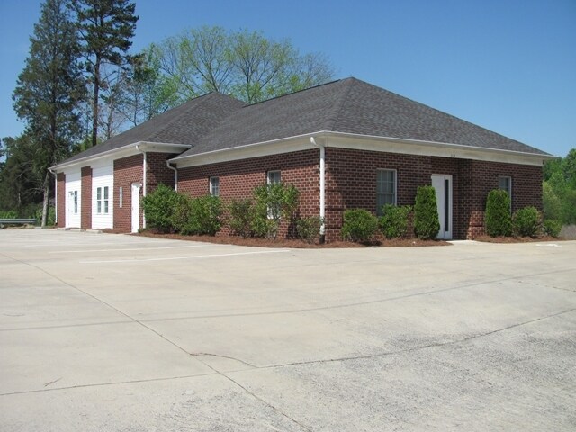
Property Record
213 Hillstone Pl, Jamestown, NC 27282


Property Detail
213 Hillstone Pl
0160378
24 PHII PB137-87 JAMESTWN BUSINESS PARK PL:137-87
Industrialgeneral
Guilford
MS
North Carolina
B and X Area of moderate flood hazard, usually the area between the limits of the 100-year and 500-year floods.
24
2024
0.50 AC
2025
High Point/SW Guilford Cty
016410
Greensboro/Winston-Salem
3,012 SF
Greensboro-High Point, NC
NEARBY LISTINGS FOR SALE OR LEASE
DEMOGRAPHICS near 213 Hillstone Pl
1 mile
3 mile
5 mile
2025 Total Population
3,498
39,066
117,959
2030 Population
3,661
40,347
121,799
Pop Growth 2025-2030
+ 4.66%
+ 3.28%
+ 3.26%
Average Age
44
42
39
2025 Total Households
1,449
15,909
47,050
HH Growth 2025-2030
+ 4.90%
+ 3.43%
+ 3.45%
Median Household Inc
$82,828
$79,577
$64,849
Avg Household Size
2.40
2.40
2.40
2025 Avg HH Vehicles
2.00
2.00
2.00
Median Home Value
$287,256
$259,972
$239,482
Median Year Built
1989
1992
1988
Nearby Places
Map Layers
Map Styles
 Street
 Aerial
Layers
 Traffic
 Biking
Places
Listings with unknown addresses are not visible on the map
- Restaurants
- Banks
- Shops
- Fitness
- Groceries
PUBLIC TRANSPORTATION
COMMUTER RAIL
High Point Station (Piedmont - North Carolina by Train (NC Train))
Drive
Walk
Distance
High Point Station (Piedmont - North Carolina by Train (NC Train))
12 min
6.6 mi
AIRPORT
Piedmont Triad International
Drive
Walk
Distance
Piedmont Triad International
22 min
9.8 mi
Freight Ports
Port of Wilmington
Drive
Walk
Distance
Port of Wilmington
255 min
215.2 mi
SALE & LEASE HISTORY
LISTING DATE
SALE/LEASE

Apr 08, 2021
For Sale
Nearby Properties
Address
Land Use
TOTAL SIZE
Lot Size
Zoning
Address
Land Use
TOTAL SIZE
Lot Size
Zoning
341,210 SF
13.43 AC
PUD
Address
Land Use
TOTAL SIZE
Lot Size
Zoning
536,466 SF
46.90 AC
PUD
Address
Land Use
TOTAL SIZE
Lot Size
Zoning
419,281 SF
25.12 AC
CIV
Address
Land Use
TOTAL SIZE
Lot Size
Zoning
805,958 SF
61.42 AC
LI
Address
Land Use
TOTAL SIZE
Lot Size
Zoning
1,259,149 SF
46.12 AC
HB
Address
Land Use
TOTAL SIZE
Lot Size
Zoning
354,454 SF
20.65 AC
RM-18
Address
Land Use
TOTAL SIZE
Lot Size
Zoning
291,895 SF
21.52 AC
RM-26
Address
Land Use
TOTAL SIZE
Lot Size
Zoning
363,308 SF
29.41 AC
RM-16
Address
Land Use
TOTAL SIZE
Lot Size
Zoning
231,597 SF
8.46 AC
PD-R
Address
Land Use
TOTAL SIZE
Lot Size
Zoning
395,043 SF
15.74 AC
PUD
Address
Land Use
TOTAL SIZE
Lot Size
Zoning
30,322 SF
964.25 AC
PNR
Address
Land Use
TOTAL SIZE
Lot Size
Zoning
299,349 SF
21.76 AC
RM-16
Address
Land Use
TOTAL SIZE
Lot Size
Zoning
403,590 SF
72.06 AC
CIV
Address
Land Use
TOTAL SIZE
Lot Size
Zoning
144,746 SF
8.17 AC
AG
Address
Land Use
TOTAL SIZE
Lot Size
Zoning
128,435 SF
10.40 AC
LI
Address
Land Use
TOTAL SIZE
Lot Size
Zoning
324,986 SF
24.19 AC
LI
Address
Land Use
TOTAL SIZE
Lot Size
Zoning
473,040 SF
63.60 AC
AG
Address
Land Use
TOTAL SIZE
Lot Size
Zoning
272,917 SF
33.57 AC
MS
Address
Land Use
TOTAL SIZE
Lot Size
Zoning
91,414 SF
11.72 AC
C-H
Address
Land Use
TOTAL SIZE
Lot Size
Zoning
33,771 SF
196.93 AC
PI
Address
Land Use
TOTAL SIZE
Lot Size
Zoning
72,851 SF
9.13 AC
IND
Address
Land Use
TOTAL SIZE
Lot Size
Zoning
113,866 SF
11.53 AC
LI
Address
Land Use
TOTAL SIZE
Lot Size
Zoning
79,022 SF
6.52 AC
CIV
Address
Land Use
TOTAL SIZE
Lot Size
Zoning
13,772 SF
167.15 AC
CIV
Address
Land Use
TOTAL SIZE
Lot Size
Zoning
89,183 SF
17.12 AC
GB
Address
Land Use
TOTAL SIZE
Lot Size
Zoning
64,721 SF
10.65 AC
AG
Address
Land Use
TOTAL SIZE
Lot Size
Zoning
130,599 SF
9.85 AC
RM-16
Address
Land Use
TOTAL SIZE
Lot Size
Zoning
63,326 SF
14.81 AC
CIV
Address
Land Use
TOTAL SIZE
Lot Size
Zoning
144,843 SF
22.14 AC
MS
Address
Land Use
TOTAL SIZE
Lot Size
Zoning
53,097 SF
6.36 AC
MS
The World's #1 Commercial Real Estate Marketplace
Connect with us
© 2026 CoStar Group
The information above has been obtained from sources believed reliable. While we do not doubt its accuracy we have not verified it and make no guarantee, warranty or representation about it. It is your responsibility to independently confirm its accuracy and completeness. Any projections, opinions, assumptions, or estimates used are for example only and do not represent the current or future performance of the property. The value of this transaction to you depends on tax and other factors which should be evaluated by your tax, financial, and legal advisors. You and your advisors should conduct a careful, independent investigation of the property to determine to your satisfaction the suitability of the property for your needs.