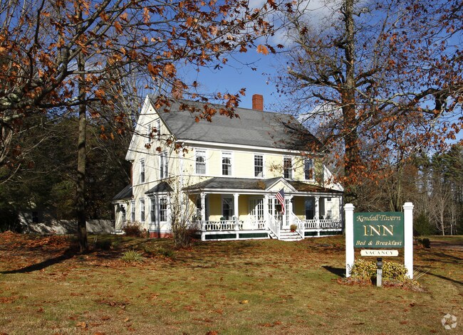
Property Record
213 Main St, Freeport, ME 04032
NEARBY LISTINGS FOR SALE OR LEASE
-
-
View all Freeport listings for sale on LoopNet.com
Property Detail
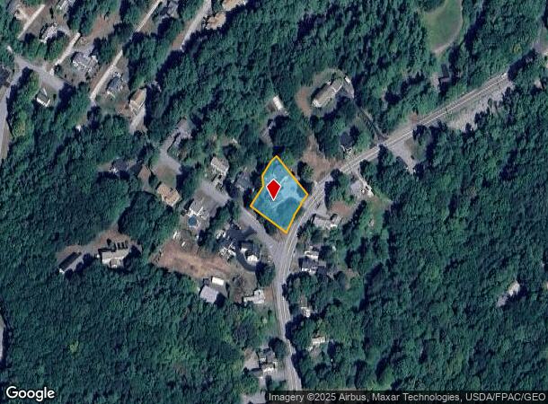
213 Main St
Portland-South Portland, ME
Cumberland
FPRT-000015-000010
Maine
Residentialnec
0.50 AC
X
Portland Surrounding
23005C0551F
Portland/South Portland
5,615 SF
DEMOGRAPHICS near 213 Main St
1 Mile
3 Mile
5 Mile
2024 Total Population
1,741
7,079
12,332
2029 Population
1,822
7,358
12,759
Pop Growth 2024-2029
+ 4.65%
+ 3.94%
+ 3.46%
Average Age
43
44
44
2024 Total Households
731
2,819
4,925
HH Growth 2024-2029
+ 4.79%
+ 3.94%
+ 3.49%
Median Household Inc
$79,167
$86,816
$90,861
Avg Household Size
2.20
2.40
2.40
2024 Avg HH Vehicles
2.00
2.00
2.00
Median Home Value
$369,026
$427,621
$429,047
Median Year Built
1975
1978
1980
Nearby Places
Map Layers
Map Styles
 Street
 Aerial
- Restaurants
- Banks
- Shops
- Fitness
- Groceries
PUBLIC TRANSPORTATION
COMMUTER RAIL
Freeport Amtrak Station (Downeaster - Amtrak)
DRIVE
WALK
Distance
Freeport Amtrak Station (Downeaster - Amtrak)
2 min
15 min
0.8 mi
Brunswick Amtrak Station (Downeaster - Amtrak)
DRIVE
WALK
Distance
Brunswick Amtrak Station (Downeaster - Amtrak)
14 min
8.3 mi
AIRPORT
Portland International Jetport
DRIVE
WALK
Distance
Portland International Jetport
30 min
21.3 mi
Freight Ports
Portland, ME
DRIVE
WALK
Distance
Portland, ME
24 min
18.3 mi
SALE & LEASE HISTORY
LISTING DATE
SALE/LEASE

Jan 06, 2023
For Sale
Nearby Properties
Address
Land Use
TOTAL SIZE
Lot Size
Zoning
Address
Land Use
TOTAL SIZE
Lot Size
Zoning
90 AC
CM03
Address
Land Use
TOTAL SIZE
Lot Size
Zoning
3.63 AC
CM01
Address
Land Use
TOTAL SIZE
Lot Size
Zoning
7.53 AC
CM01
Address
Land Use
TOTAL SIZE
Lot Size
Zoning
24 AC
CM02
Address
Land Use
TOTAL SIZE
Lot Size
Zoning
38.65 AC
CM03
Address
Land Use
TOTAL SIZE
Lot Size
Zoning
350,171 SF
78.45 AC
CM03
Address
Land Use
TOTAL SIZE
Lot Size
Zoning
432,630 SF
CM03
Address
Land Use
TOTAL SIZE
Lot Size
Zoning
20 AC
CM03
Address
Land Use
TOTAL SIZE
Lot Size
Zoning
0.66 AC
1400
Address
Land Use
TOTAL SIZE
Lot Size
Zoning
2,469 SF
3.84 AC
CM03
Address
Land Use
TOTAL SIZE
Lot Size
Zoning
5.15 AC
CM03
Address
Land Use
TOTAL SIZE
Lot Size
Zoning
1.46 AC
CM03
Address
Land Use
TOTAL SIZE
Lot Size
Zoning
45,829 SF
0.94 AC
CM01
Address
Land Use
TOTAL SIZE
Lot Size
Zoning
58,718 SF
13 AC
CM04
Address
Land Use
TOTAL SIZE
Lot Size
Zoning
59,699 SF
6.60 AC
CM02
Address
Land Use
TOTAL SIZE
Lot Size
Zoning
60,270 SF
21.80 AC
550
Address
Land Use
TOTAL SIZE
Lot Size
Zoning
84.10 AC
CM05
Address
Land Use
TOTAL SIZE
Lot Size
Zoning
Address
Land Use
TOTAL SIZE
Lot Size
Zoning
29,680 SF
0.79 AC
CM01
Address
Land Use
TOTAL SIZE
Lot Size
Zoning
39,225 SF
21.43 AC
CM03
Address
Land Use
TOTAL SIZE
Lot Size
Zoning
1.01 AC
CM02
Address
Land Use
TOTAL SIZE
Lot Size
Zoning
41,451 SF
2.90 AC
CM03
Address
Land Use
TOTAL SIZE
Lot Size
Zoning
38,209 SF
2.26 AC
CM02
Address
Land Use
TOTAL SIZE
Lot Size
Zoning
38,323 SF
2.14 AC
CM03
Address
Land Use
TOTAL SIZE
Lot Size
Zoning
5.11 AC
CM02
Address
Land Use
TOTAL SIZE
Lot Size
Zoning
2,189 SF
3.63 AC
CM01
Address
Land Use
TOTAL SIZE
Lot Size
Zoning
17.93 AC
CM04
Address
Land Use
TOTAL SIZE
Lot Size
Zoning
0.62 AC
CM01
Address
Land Use
TOTAL SIZE
Lot Size
Zoning
3.89 AC
CM03
Address
Land Use
TOTAL SIZE
Lot Size
Zoning
24,030 SF
2.67 AC
CM03
The World's #1 Commercial Real Estate Marketplace
Connect with us
© 2026 CoStar Group
The information above has been obtained from sources believed reliable. While we do not doubt its accuracy we have not verified it and make no guarantee, warranty or representation about it. It is your responsibility to independently confirm its accuracy and completeness. Any projections, opinions, assumptions, or estimates used are for example only and do not represent the current or future performance of the property. The value of this transaction to you depends on tax and other factors which should be evaluated by your tax, financial, and legal advisors. You and your advisors should conduct a careful, independent investigation of the property to determine to your satisfaction the suitability of the property for your needs.