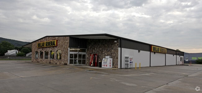
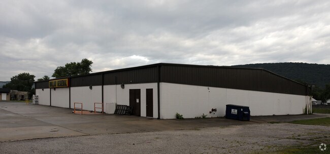
Property Record
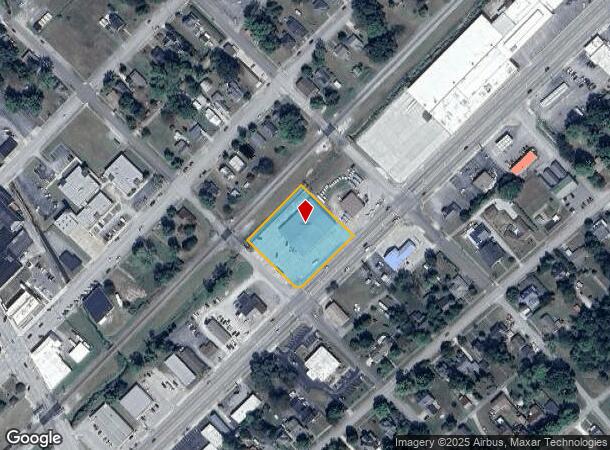
213 N Gateway Ave, Rockwood, TN 37854
NEARBY LISTINGS FOR SALE OR LEASE
Property Detail
213 N Gateway Ave
Knoxville, TN
City Of Rockwood
054E-K-004.00
DISTRICT: 5; SUBDIVISION: CITY OF ROCKWOOD; BLOCK: 61
Storebuilding
Roane
AE
Tennessee
47121C0025F
1-10
0
1.29 AC
2025
Knoxville Area
030500
Other Market Areas
15,950 SF
DEMOGRAPHICS near 213 N Gateway Ave
1 Mile
3 Mile
5 Mile
2024 Total Population
4,135
8,242
11,401
2029 Population
4,501
8,944
12,357
Pop Growth 2024-2029
+ 8.85%
+ 8.52%
+ 8.39%
Average Age
42
44
44
2024 Total Households
1,723
3,462
4,764
HH Growth 2024-2029
+ 8.88%
+ 8.49%
+ 8.38%
Median Household Inc
$40,051
$47,172
$51,623
Avg Household Size
2.30
2.30
2.30
2024 Avg HH Vehicles
2.00
2.00
2.00
Median Home Value
$104,639
$134,419
$152,749
Median Year Built
1958
1969
1974
Nearby Places
Map Layers
Map Styles
 Street
 Aerial
- Restaurants
- Banks
- Shops
- Fitness
- Groceries
Nearby Properties
Address
Land Use
TOTAL SIZE
Lot Size
Zoning
Address
Land Use
TOTAL SIZE
Lot Size
Zoning
17,991 SF
10.80 AC
Address
Land Use
TOTAL SIZE
Lot Size
Zoning
1,067.90 AC
Address
Land Use
TOTAL SIZE
Lot Size
Zoning
6,536 SF
111.90 AC
Address
Land Use
TOTAL SIZE
Lot Size
Zoning
190,022 SF
25.83 AC
Address
Land Use
TOTAL SIZE
Lot Size
Zoning
7,778 SF
18.40 AC
Address
Land Use
TOTAL SIZE
Lot Size
Zoning
1,310 AC
Address
Land Use
TOTAL SIZE
Lot Size
Zoning
4,856 SF
3.95 AC
Address
Land Use
TOTAL SIZE
Lot Size
Zoning
19,240 SF
18.25 AC
Address
Land Use
TOTAL SIZE
Lot Size
Zoning
36,851 SF
13.80 AC
Address
Land Use
TOTAL SIZE
Lot Size
Zoning
81,694 SF
16.60 AC
Address
Land Use
TOTAL SIZE
Lot Size
Zoning
87,970 SF
3.70 AC
Address
Land Use
TOTAL SIZE
Lot Size
Zoning
85,605 SF
7.84 AC
Address
Land Use
TOTAL SIZE
Lot Size
Zoning
12,602 SF
83.48 AC
Address
Land Use
TOTAL SIZE
Lot Size
Zoning
10,208 SF
17.34 AC
Address
Land Use
TOTAL SIZE
Lot Size
Zoning
209.60 AC
Address
Land Use
TOTAL SIZE
Lot Size
Zoning
Address
Land Use
TOTAL SIZE
Lot Size
Zoning
49,666 SF
44.95 AC
Address
Land Use
TOTAL SIZE
Lot Size
Zoning
248,439 SF
9.26 AC
M1
Address
Land Use
TOTAL SIZE
Lot Size
Zoning
77,469 SF
11.31 AC
Address
Land Use
TOTAL SIZE
Lot Size
Zoning
44.60 AC
Address
Land Use
TOTAL SIZE
Lot Size
Zoning
10,598 SF
24.20 AC
Address
Land Use
TOTAL SIZE
Lot Size
Zoning
2,800 SF
22.34 AC
Address
Land Use
TOTAL SIZE
Lot Size
Zoning
2,800 SF
22.34 AC
Address
Land Use
TOTAL SIZE
Lot Size
Zoning
136.80 AC
Address
Land Use
TOTAL SIZE
Lot Size
Zoning
239 AC
Address
Land Use
TOTAL SIZE
Lot Size
Zoning
16,530 SF
1.66 AC
Address
Land Use
TOTAL SIZE
Lot Size
Zoning
16.50 AC
Address
Land Use
TOTAL SIZE
Lot Size
Zoning
8,041 SF
0.34 AC
Address
Land Use
TOTAL SIZE
Lot Size
Zoning
21,076 SF
2.29 AC
Address
Land Use
TOTAL SIZE
Lot Size
Zoning
30.36 AC
The World's #1 Commercial Real Estate Marketplace
Connect with us
© 2025 CoStar Group
The information above has been obtained from sources believed reliable. While we do not doubt its accuracy we have not verified it and make no guarantee, warranty or representation about it. It is your responsibility to independently confirm its accuracy and completeness. Any projections, opinions, assumptions, or estimates used are for example only and do not represent the current or future performance of the property. The value of this transaction to you depends on tax and other factors which should be evaluated by your tax, financial, and legal advisors. You and your advisors should conduct a careful, independent investigation of the property to determine to your satisfaction the suitability of the property for your needs.