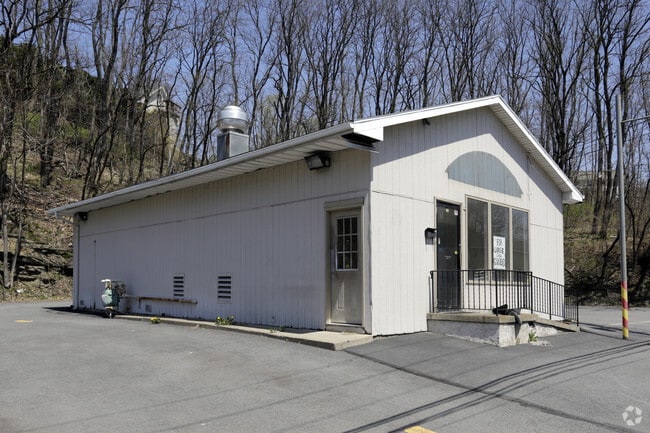
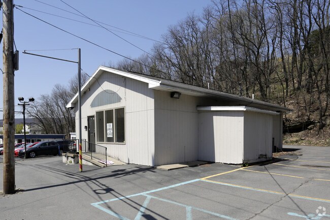
Property Record
213 N Main St, Old Forge, PA 18518
NEARBY LISTINGS FOR SALE OR LEASE
Property Detail
213 N Main St
Scranton--Wilkes-Barre--Hazelton, PA
Marwood Land Company
1760901001701
47X124X180X81X81X120X136 W-06 B-0200 L-0250
Taxexempt
Lackawanna
X
Pennsylvania
42069C0301D
250
2025
0.87 AC
2025
I-81 Corridor
112600
Philadelphia
DEMOGRAPHICS near 213 N Main St
1 Mile
3 Mile
5 Mile
2024 Total Population
7,962
33,308
97,635
2029 Population
7,884
32,952
97,017
Pop Growth 2024-2029
(0.98%)
(1.07%)
(0.63%)
Average Age
44
43
41
2024 Total Households
3,466
14,464
40,540
HH Growth 2024-2029
(0.89%)
(1.04%)
(0.61%)
Median Household Inc
$68,261
$66,419
$55,052
Avg Household Size
2.20
2.30
2.20
2024 Avg HH Vehicles
2.00
2.00
2.00
Median Home Value
$155,505
$156,998
$143,454
Median Year Built
1958
1958
1949
Nearby Places
Map Layers
Map Styles
 Street
 Aerial
- Restaurants
- Banks
- Shops
- Fitness
- Groceries
PUBLIC TRANSPORTATION
AIRPORT
Wilkes-Barre/Scranton International
DRIVE
WALK
Distance
Wilkes-Barre/Scranton International
11 min
4.7 mi
Freight Ports
Maher Terminal
DRIVE
WALK
Distance
Maher Terminal
150 min
119.8 mi
SALE & LEASE HISTORY
LISTING DATE
SALE/LEASE

Jul 26, 2019
For Sale
Nearby Properties
Address
Land Use
TOTAL SIZE
Lot Size
Zoning
Address
Land Use
TOTAL SIZE
Lot Size
Zoning
33.16 AC
Address
Land Use
TOTAL SIZE
Lot Size
Zoning
20.40 AC
Address
Land Use
TOTAL SIZE
Lot Size
Zoning
1.97 AC
Address
Land Use
TOTAL SIZE
Lot Size
Zoning
3.82 AC
Address
Land Use
TOTAL SIZE
Lot Size
Zoning
20 AC
Address
Land Use
TOTAL SIZE
Lot Size
Zoning
42.39 AC
Address
Land Use
TOTAL SIZE
Lot Size
Zoning
21.98 AC
Address
Land Use
TOTAL SIZE
Lot Size
Zoning
36.41 AC
Address
Land Use
TOTAL SIZE
Lot Size
Zoning
26.80 AC
Address
Land Use
TOTAL SIZE
Lot Size
Zoning
47.24 AC
Address
Land Use
TOTAL SIZE
Lot Size
Zoning
22.35 AC
Address
Land Use
TOTAL SIZE
Lot Size
Zoning
34.52 AC
Address
Land Use
TOTAL SIZE
Lot Size
Zoning
34.57 AC
Address
Land Use
TOTAL SIZE
Lot Size
Zoning
8.25 AC
Address
Land Use
TOTAL SIZE
Lot Size
Zoning
48.45 AC
Address
Land Use
TOTAL SIZE
Lot Size
Zoning
0.65 AC
Address
Land Use
TOTAL SIZE
Lot Size
Zoning
Address
Land Use
TOTAL SIZE
Lot Size
Zoning
13.53 AC
Address
Land Use
TOTAL SIZE
Lot Size
Zoning
24.60 AC
Address
Land Use
TOTAL SIZE
Lot Size
Zoning
Address
Land Use
TOTAL SIZE
Lot Size
Zoning
14.32 AC
Address
Land Use
TOTAL SIZE
Lot Size
Zoning
51.10 AC
Address
Land Use
TOTAL SIZE
Lot Size
Zoning
7.82 AC
Address
Land Use
TOTAL SIZE
Lot Size
Zoning
0.40 AC
Address
Land Use
TOTAL SIZE
Lot Size
Zoning
2.04 AC
Address
Land Use
TOTAL SIZE
Lot Size
Zoning
Address
Land Use
TOTAL SIZE
Lot Size
Zoning
Address
Land Use
TOTAL SIZE
Lot Size
Zoning
9.91 AC
Address
Land Use
TOTAL SIZE
Lot Size
Zoning
3.44 AC
Address
Land Use
TOTAL SIZE
Lot Size
Zoning
The World's #1 Commercial Real Estate Marketplace
Connect with us
© 2025 CoStar Group
The information above has been obtained from sources believed reliable. While we do not doubt its accuracy we have not verified it and make no guarantee, warranty or representation about it. It is your responsibility to independently confirm its accuracy and completeness. Any projections, opinions, assumptions, or estimates used are for example only and do not represent the current or future performance of the property. The value of this transaction to you depends on tax and other factors which should be evaluated by your tax, financial, and legal advisors. You and your advisors should conduct a careful, independent investigation of the property to determine to your satisfaction the suitability of the property for your needs.