Property Record
213 Pancoast St, Scranton, PA 18512

NEARBY LISTINGS FOR SALE OR LEASE
-
-
View all Scranton listings for sale on LoopNet.com
Property Detail
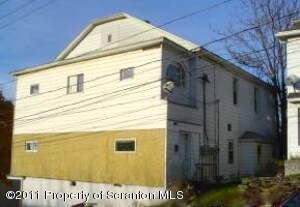
213 Pancoast St
Scranton--Wilkes-Barre--Hazelton, PA
Price Pancoast & Throop
12415020059
50X135X129 BLDG & LAND W-03 B-0040 L-0190 P-02900
Quadruplex
Lackawanna
X
Pennsylvania
42069C0209D
190
2025
0.17 AC
2025
Throop
112000
Philadelphia
DEMOGRAPHICS near 213 Pancoast St
1 Mile
3 Mile
5 Mile
2024 Total Population
8,201
63,291
128,308
2029 Population
8,099
62,622
127,051
Pop Growth 2024-2029
(1.24%)
(1.06%)
(0.98%)
Average Age
42
41
41
2024 Total Households
3,390
26,133
52,449
HH Growth 2024-2029
(1.33%)
(1.13%)
(1.01%)
Median Household Inc
$57,003
$55,879
$56,875
Avg Household Size
2.20
2.20
2.20
2024 Avg HH Vehicles
2.00
2.00
2.00
Median Home Value
$145,549
$153,665
$158,229
Median Year Built
1948
1948
1949
Nearby Places
Map Layers
Map Styles
 Street
 Aerial
- Restaurants
- Banks
- Shops
- Fitness
- Groceries
PUBLIC TRANSPORTATION
AIRPORT
Wilkes-Barre/Scranton International
DRIVE
WALK
Distance
Wilkes-Barre/Scranton International
22 min
13.6 mi
Freight Ports
Maher Terminal
DRIVE
WALK
Distance
Maher Terminal
145 min
114.6 mi
Nearby Properties
Address
Land Use
TOTAL SIZE
Lot Size
Zoning
Address
Land Use
TOTAL SIZE
Lot Size
Zoning
2.62 AC
Address
Land Use
TOTAL SIZE
Lot Size
Zoning
43.66 AC
Address
Land Use
TOTAL SIZE
Lot Size
Zoning
Address
Land Use
TOTAL SIZE
Lot Size
Zoning
112.27 AC
Address
Land Use
TOTAL SIZE
Lot Size
Zoning
4.20 AC
Address
Land Use
TOTAL SIZE
Lot Size
Zoning
3.86 AC
Address
Land Use
TOTAL SIZE
Lot Size
Zoning
12.88 AC
Address
Land Use
TOTAL SIZE
Lot Size
Zoning
7.81 AC
Address
Land Use
TOTAL SIZE
Lot Size
Zoning
Address
Land Use
TOTAL SIZE
Lot Size
Zoning
43.52 AC
Address
Land Use
TOTAL SIZE
Lot Size
Zoning
Address
Land Use
TOTAL SIZE
Lot Size
Zoning
25.62 AC
Address
Land Use
TOTAL SIZE
Lot Size
Zoning
2.65 AC
Address
Land Use
TOTAL SIZE
Lot Size
Zoning
Address
Land Use
TOTAL SIZE
Lot Size
Zoning
97.16 AC
Address
Land Use
TOTAL SIZE
Lot Size
Zoning
5.35 AC
Address
Land Use
TOTAL SIZE
Lot Size
Zoning
3.86 AC
Address
Land Use
TOTAL SIZE
Lot Size
Zoning
Address
Land Use
TOTAL SIZE
Lot Size
Zoning
9.55 AC
Address
Land Use
TOTAL SIZE
Lot Size
Zoning
Address
Land Use
TOTAL SIZE
Lot Size
Zoning
Address
Land Use
TOTAL SIZE
Lot Size
Zoning
43.89 AC
Address
Land Use
TOTAL SIZE
Lot Size
Zoning
28.89 AC
Address
Land Use
TOTAL SIZE
Lot Size
Zoning
3.12 AC
Address
Land Use
TOTAL SIZE
Lot Size
Zoning
Address
Land Use
TOTAL SIZE
Lot Size
Zoning
Address
Land Use
TOTAL SIZE
Lot Size
Zoning
38.12 AC
Address
Land Use
TOTAL SIZE
Lot Size
Zoning
0.69 AC
Address
Land Use
TOTAL SIZE
Lot Size
Zoning
5.65 AC
Address
Land Use
TOTAL SIZE
Lot Size
Zoning
3.73 AC
The World's #1 Commercial Real Estate Marketplace
Connect with us
© 2025 CoStar Group
The information above has been obtained from sources believed reliable. While we do not doubt its accuracy we have not verified it and make no guarantee, warranty or representation about it. It is your responsibility to independently confirm its accuracy and completeness. Any projections, opinions, assumptions, or estimates used are for example only and do not represent the current or future performance of the property. The value of this transaction to you depends on tax and other factors which should be evaluated by your tax, financial, and legal advisors. You and your advisors should conduct a careful, independent investigation of the property to determine to your satisfaction the suitability of the property for your needs.