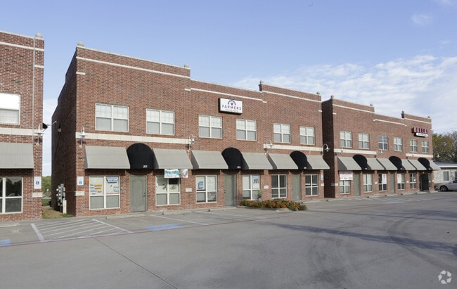
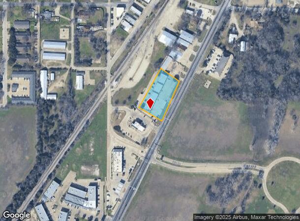
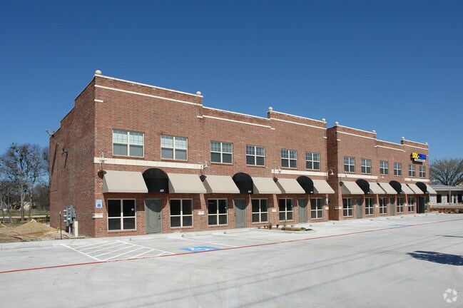
Property Record
213 S State Highway 342, Red Oak, TX 75154
NEARBY LISTINGS FOR SALE OR LEASE
Property Detail
213 S State Highway 342
Dallas-Fort Worth-Arlington, TX
Minyard Addition
179852
LOT 1 BLK A MINYARD ADDITION 1.332 AC
Commercialnec
Ellis
X
Texas
48139C0070G
1
2024
1.33 AC
2025
Southwest Outlying
060207
Dallas/Ft Worth
22,728 SF
DEMOGRAPHICS near 213 S State Highway 342
1 mile
3 mile
5 mile
2024 Total Population
6,897
27,842
66,948
2029 Population
8,650
35,123
79,718
Pop Growth 2024-2029
+ 25.42%
+ 26.15%
+ 19.07%
Average Age
36
38
37
2024 Total Households
2,352
9,352
22,234
HH Growth 2024-2029
+ 25.72%
+ 26.48%
+ 19.44%
Median Household Inc
$92,048
$100,022
$94,487
Avg Household Size
2.90
2.90
3.00
2024 Avg HH Vehicles
2.00
2.00
2.00
Median Home Value
$256,561
$262,079
$260,900
Median Year Built
2001
1998
1999
Nearby Places
Map Layers
Map Styles
 Street
 Aerial
Transit
 Traffic
 Biking
Places
Listings with unknown addresses are not visible on the map
- Restaurants
- Banks
- Shops
- Fitness
- Groceries
PUBLIC TRANSPORTATION
AIRPORT
Dallas Love Field
Drive
Walk
Distance
Dallas Love Field
38 min
26.2 mi
Dallas-Fort Worth International
Drive
Walk
Distance
Dallas-Fort Worth International
51 min
39.8 mi
SALE & LEASE HISTORY
LISTING DATE
SALE/LEASE

Sep 25, 2016
For Lease
Nearby Properties
Address
Land Use
TOTAL SIZE
Lot Size
Zoning
Address
Land Use
TOTAL SIZE
Lot Size
Zoning
268,416 SF
33.28 AC
Address
Land Use
TOTAL SIZE
Lot Size
Zoning
268,416 SF
19.04 AC
Address
Land Use
TOTAL SIZE
Lot Size
Zoning
268,416 SF
20.02 AC
Address
Land Use
TOTAL SIZE
Lot Size
Zoning
268,416 SF
19.18 AC
Address
Land Use
TOTAL SIZE
Lot Size
Zoning
364,814 SF
105.96 AC
Address
Land Use
TOTAL SIZE
Lot Size
Zoning
288,368 SF
86.46 AC
Address
Land Use
TOTAL SIZE
Lot Size
Zoning
316,312 SF
17.09 AC
Address
Land Use
TOTAL SIZE
Lot Size
Zoning
332,510 SF
18.45 AC
Address
Land Use
TOTAL SIZE
Lot Size
Zoning
268,416 SF
22.11 AC
Address
Land Use
TOTAL SIZE
Lot Size
Zoning
345,348 SF
19.22 AC
Address
Land Use
TOTAL SIZE
Lot Size
Zoning
281,216 SF
75.37 AC
Address
Land Use
TOTAL SIZE
Lot Size
Zoning
247,018 SF
16.28 AC
Address
Land Use
TOTAL SIZE
Lot Size
Zoning
196,670 SF
47.43 AC
Address
Land Use
TOTAL SIZE
Lot Size
Zoning
80,000 SF
8.37 AC
Address
Land Use
TOTAL SIZE
Lot Size
Zoning
268,416 SF
18.38 AC
Address
Land Use
TOTAL SIZE
Lot Size
Zoning
41,390 SF
90.38 AC
Address
Land Use
TOTAL SIZE
Lot Size
Zoning
104,885 SF
8 AC
Address
Land Use
TOTAL SIZE
Lot Size
Zoning
111,715 SF
4.81 AC
Address
Land Use
TOTAL SIZE
Lot Size
Zoning
268,416 SF
18.32 AC
Address
Land Use
TOTAL SIZE
Lot Size
Zoning
268,416 SF
91.89 AC
Address
Land Use
TOTAL SIZE
Lot Size
Zoning
110,065 SF
8.29 AC
Address
Land Use
TOTAL SIZE
Lot Size
Zoning
116,318 SF
14.92 AC
Address
Land Use
TOTAL SIZE
Lot Size
Zoning
40,071 SF
15.96 AC
Address
Land Use
TOTAL SIZE
Lot Size
Zoning
159,860 SF
24.03 AC
Address
Land Use
TOTAL SIZE
Lot Size
Zoning
268,416 SF
19.64 AC
Address
Land Use
TOTAL SIZE
Lot Size
Zoning
91,204 SF
5.04 AC
Address
Land Use
TOTAL SIZE
Lot Size
Zoning
43,164 SF
17.44 AC
Address
Land Use
TOTAL SIZE
Lot Size
Zoning
268,416 SF
40.26 AC
Address
Land Use
TOTAL SIZE
Lot Size
Zoning
181,425 SF
38.96 AC
Address
Land Use
TOTAL SIZE
Lot Size
Zoning
51,744 SF
1.88 AC
The World's #1 Commercial Real Estate Marketplace
Connect with us
© 2026 CoStar Group
The information above has been obtained from sources believed reliable. While we do not doubt its accuracy we have not verified it and make no guarantee, warranty or representation about it. It is your responsibility to independently confirm its accuracy and completeness. Any projections, opinions, assumptions, or estimates used are for example only and do not represent the current or future performance of the property. The value of this transaction to you depends on tax and other factors which should be evaluated by your tax, financial, and legal advisors. You and your advisors should conduct a careful, independent investigation of the property to determine to your satisfaction the suitability of the property for your needs.