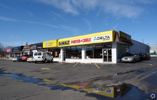
Property Record
213 Route 46 W, Eelmwood Park, NJ 07407


Current Lease Availabilities
NEARBY LISTINGS FOR SALE OR LEASE
Property Detail
213 Route 46 W
11-01706-0000-00001
0.854
Commercialnec
Bergen
X
New Jersey
34031C0238G
1
2024
0.85 AC
2025
Route 46 Corridor
011400
Northern New Jersey
13,740 SF
New York-Jersey City-White Plains, NY-NJ
DEMOGRAPHICS near 213 Route 46 W
1 Mile
3 Mile
5 Mile
2024 Total Population
23,467
307,598
653,354
2029 Population
22,644
297,594
635,917
Pop Growth 2024-2029
(3.51%)
(3.25%)
(2.67%)
Average Age
40
38
39
2024 Total Households
8,484
103,364
226,790
HH Growth 2024-2029
(3.60%)
(3.35%)
(2.67%)
Median Household Inc
$79,533
$65,555
$75,382
Avg Household Size
2.70
2.90
2.80
2024 Avg HH Vehicles
2.00
2.00
2.00
Median Home Value
$412,650
$408,846
$433,896
Median Year Built
1954
1952
1954
Nearby Places
- Restaurants
- Banks
- Shops
- Fitness
- Groceries
PUBLIC TRANSPORTATION
COMMUTER RAIL
Plauderville (Bergen County/Port Jervis Line - NJ Transit Commuter Rail (NJ Transit))
DRIVE
WALK
Distance
Plauderville (Bergen County/Port Jervis Line - NJ Transit Commuter Rail (NJ Transit))
4 min
2.3 mi
Garfield (Bergen County/Port Jervis Line - NJ Transit Commuter Rail (NJ Transit))
DRIVE
WALK
Distance
Garfield (Bergen County/Port Jervis Line - NJ Transit Commuter Rail (NJ Transit))
6 min
3.4 mi
AIRPORT
Newark Liberty International
DRIVE
WALK
Distance
Newark Liberty International
23 min
19.2 mi
LaGuardia
DRIVE
WALK
Distance
LaGuardia
34 min
23.1 mi
Westchester County
DRIVE
WALK
Distance
Westchester County
55 min
38.9 mi
Freight Ports
Port Newark Container Terminal
DRIVE
WALK
Distance
Port Newark Container Terminal
26 min
18.5 mi
Nearby Properties
Address
Land Use
TOTAL SIZE
Lot Size
Zoning
Address
Land Use
TOTAL SIZE
Lot Size
Zoning
Address
Land Use
TOTAL SIZE
Lot Size
Zoning
136.31 AC
Address
Land Use
TOTAL SIZE
Lot Size
Zoning
8.75 AC
Address
Land Use
TOTAL SIZE
Lot Size
Zoning
7.10 AC
R-3
Address
Land Use
TOTAL SIZE
Lot Size
Zoning
12,506 SF
130 AC
B-2
Address
Land Use
TOTAL SIZE
Lot Size
Zoning
160,036 SF
21.93 AC
R75
Address
Land Use
TOTAL SIZE
Lot Size
Zoning
8.66 AC
CH1
Address
Land Use
TOTAL SIZE
Lot Size
Zoning
197,742 SF
6.20 AC
R3
Address
Land Use
TOTAL SIZE
Lot Size
Zoning
25.50 AC
B2
Address
Land Use
TOTAL SIZE
Lot Size
Zoning
26,816 SF
25.50 AC
POP
Address
Land Use
TOTAL SIZE
Lot Size
Zoning
242,048 SF
25.40 AC
BLL
Address
Land Use
TOTAL SIZE
Lot Size
Zoning
Address
Land Use
TOTAL SIZE
Lot Size
Zoning
286,500 SF
26.90 AC
LL
Address
Land Use
TOTAL SIZE
Lot Size
Zoning
82.74 AC
Address
Land Use
TOTAL SIZE
Lot Size
Zoning
16.94 AC
R2
Address
Land Use
TOTAL SIZE
Lot Size
Zoning
24.35 AC
Address
Land Use
TOTAL SIZE
Lot Size
Zoning
152,050 SF
1.96 AC
B-1
Address
Land Use
TOTAL SIZE
Lot Size
Zoning
13.36 AC
Address
Land Use
TOTAL SIZE
Lot Size
Zoning
7.83 AC
Address
Land Use
TOTAL SIZE
Lot Size
Zoning
5.40 AC
RB
Address
Land Use
TOTAL SIZE
Lot Size
Zoning
Address
Land Use
TOTAL SIZE
Lot Size
Zoning
31.63 AC
I
Address
Land Use
TOTAL SIZE
Lot Size
Zoning
18.14 AC
R3
Address
Land Use
TOTAL SIZE
Lot Size
Zoning
6,712 SF
92 AC
C
Address
Land Use
TOTAL SIZE
Lot Size
Zoning
21.80 AC
R-A3
Address
Land Use
TOTAL SIZE
Lot Size
Zoning
Address
Land Use
TOTAL SIZE
Lot Size
Zoning
6.66 AC
RM
Address
Land Use
TOTAL SIZE
Lot Size
Zoning
0.01 AC
Address
Land Use
TOTAL SIZE
Lot Size
Zoning
95,682 SF
6.44 AC
LL
Address
Land Use
TOTAL SIZE
Lot Size
Zoning
61,317 SF
7.91 AC
BL
The World's #1 Commercial Real Estate Marketplace
Connect with us
© 2025 CoStar Group
The information above has been obtained from sources believed reliable. While we do not doubt its accuracy we have not verified it and make no guarantee, warranty or representation about it. It is your responsibility to independently confirm its accuracy and completeness. Any projections, opinions, assumptions, or estimates used are for example only and do not represent the current or future performance of the property. The value of this transaction to you depends on tax and other factors which should be evaluated by your tax, financial, and legal advisors. You and your advisors should conduct a careful, independent investigation of the property to determine to your satisfaction the suitability of the property for your needs.