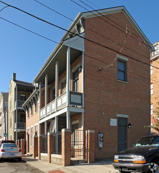
Property Record
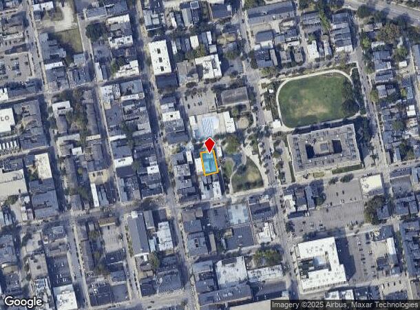
213 Woodward St, Cincinnati, OH 45202
NEARBY LISTINGS FOR SALE OR LEASE
Property Detail
213 Woodward St
075-0004-0384
Willkommen E Condominium
Officecondo
UNIT A-133.334%WILLKOMMEN E CONDOMINIUM
X
Hamilton
21037C0007E
Ohio
2024
Over-The Rhine
2024
Cincinnati/Dayton
001000
Cincinnati, OH-KY-IN
DEMOGRAPHICS near 213 Woodward St
1 Mile
3 Mile
5 Mile
2024 Total Population
30,207
158,746
333,826
2029 Population
31,006
162,196
337,703
Pop Growth 2024-2029
+ 2.65%
+ 2.17%
+ 1.16%
Average Age
36
36
37
2024 Total Households
16,059
72,434
147,464
HH Growth 2024-2029
+ 2.82%
+ 2.30%
+ 1.18%
Median Household Inc
$64,738
$46,662
$49,271
Avg Household Size
1.70
2.00
2.10
2024 Avg HH Vehicles
1.00
1.00
1.00
Median Home Value
$377,583
$228,109
$211,603
Median Year Built
1949
1948
1949
Nearby Places
Map Layers
Map Styles
 Street
 Aerial
- Restaurants
- Banks
- Shops
- Fitness
- Groceries
PUBLIC TRANSPORTATION
TRANSIT/SUBWAY
Hanke Exchange Station, 12Th & Main (Streetcar - OTR - Banks - Southwest Ohio Regional Transit Authority)
DRIVE
WALK
Distance
Hanke Exchange Station, 12Th & Main (Streetcar - OTR - Banks - Southwest Ohio Regional Transit Authority)
1 min
3 min
0.2 mi
Jack Casino Station, Main & Court (Streetcar - OTR - Banks - Southwest Ohio Regional Transit Authority)
DRIVE
WALK
Distance
Jack Casino Station, Main & Court (Streetcar - OTR - Banks - Southwest Ohio Regional Transit Authority)
2 min
5 min
0.3 mi
Central Parkway & Vine Station (Streetcar - OTR - Banks - Southwest Ohio Regional Transit Authority)
DRIVE
WALK
Distance
Central Parkway & Vine Station (Streetcar - OTR - Banks - Southwest Ohio Regional Transit Authority)
1 min
7 min
0.4 mi
Washington Park Station, 12Th & Race (Streetcar - OTR - Banks - Southwest Ohio Regional Transit Authority)
DRIVE
WALK
Distance
Washington Park Station, 12Th & Race (Streetcar - OTR - Banks - Southwest Ohio Regional Transit Authority)
1 min
7 min
0.4 mi
Public Library Station, 9Th & Walnut (Streetcar - OTR - Banks - Southwest Ohio Regional Transit Authority)
DRIVE
WALK
Distance
Public Library Station, 9Th & Walnut (Streetcar - OTR - Banks - Southwest Ohio Regional Transit Authority)
1 min
8 min
0.5 mi
COMMUTER RAIL
Cincinnati Union Terminal (Cardinal - Amtrak)
DRIVE
WALK
Distance
Cincinnati Union Terminal (Cardinal - Amtrak)
6 min
1.7 mi
AIRPORT
Cincinnati/Northern Kentucky International
DRIVE
WALK
Distance
Cincinnati/Northern Kentucky International
29 min
14.9 mi
Freight Ports
Port of Toledo
DRIVE
WALK
Distance
Port of Toledo
243 min
204.4 mi
SALE & LEASE HISTORY
LISTING DATE
SALE/LEASE

Jan 14, 2025
For Lease
Nearby Properties
Address
Land Use
TOTAL SIZE
Lot Size
Zoning
Address
Land Use
TOTAL SIZE
Lot Size
Zoning
77.73 AC
IR
Address
Land Use
TOTAL SIZE
Lot Size
Zoning
6.35 AC
IR
Address
Land Use
TOTAL SIZE
Lot Size
Zoning
39.99 AC
MG
Address
Land Use
TOTAL SIZE
Lot Size
Zoning
11.82 AC
Address
Land Use
TOTAL SIZE
Lot Size
Zoning
19.36 AC
Address
Land Use
TOTAL SIZE
Lot Size
Zoning
17.10 AC
DD
Address
Land Use
TOTAL SIZE
Lot Size
Zoning
1.97 AC
DD
Address
Land Use
TOTAL SIZE
Lot Size
Zoning
11.41 AC
IR
Address
Land Use
TOTAL SIZE
Lot Size
Zoning
22.45 AC
Address
Land Use
TOTAL SIZE
Lot Size
Zoning
13.80 AC
Address
Land Use
TOTAL SIZE
Lot Size
Zoning
60,750 SF
1.52 AC
Address
Land Use
TOTAL SIZE
Lot Size
Zoning
2.60 AC
Address
Land Use
TOTAL SIZE
Lot Size
Zoning
9.55 AC
Address
Land Use
TOTAL SIZE
Lot Size
Zoning
3.09 AC
Address
Land Use
TOTAL SIZE
Lot Size
Zoning
2.80 AC
IR
Address
Land Use
TOTAL SIZE
Lot Size
Zoning
3.40 AC
IR
Address
Land Use
TOTAL SIZE
Lot Size
Zoning
89,500 SF
0.58 AC
Address
Land Use
TOTAL SIZE
Lot Size
Zoning
Address
Land Use
TOTAL SIZE
Lot Size
Zoning
290,233 SF
Address
Land Use
TOTAL SIZE
Lot Size
Zoning
3.51 AC
DD
Address
Land Use
TOTAL SIZE
Lot Size
Zoning
9,962 SF
712 AC
Address
Land Use
TOTAL SIZE
Lot Size
Zoning
Address
Land Use
TOTAL SIZE
Lot Size
Zoning
153,312 SF
4 AC
Address
Land Use
TOTAL SIZE
Lot Size
Zoning
9.14 AC
Address
Land Use
TOTAL SIZE
Lot Size
Zoning
11.68 AC
Address
Land Use
TOTAL SIZE
Lot Size
Zoning
298,611 SF
Address
Land Use
TOTAL SIZE
Lot Size
Zoning
20.02 AC
Address
Land Use
TOTAL SIZE
Lot Size
Zoning
165,016 SF
15.23 AC
Address
Land Use
TOTAL SIZE
Lot Size
Zoning
7.14 AC
Address
Land Use
TOTAL SIZE
Lot Size
Zoning
256,000 SF
The World's #1 Commercial Real Estate Marketplace
Connect with us
© 2025 CoStar Group
The information above has been obtained from sources believed reliable. While we do not doubt its accuracy we have not verified it and make no guarantee, warranty or representation about it. It is your responsibility to independently confirm its accuracy and completeness. Any projections, opinions, assumptions, or estimates used are for example only and do not represent the current or future performance of the property. The value of this transaction to you depends on tax and other factors which should be evaluated by your tax, financial, and legal advisors. You and your advisors should conduct a careful, independent investigation of the property to determine to your satisfaction the suitability of the property for your needs.