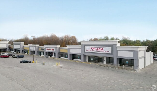
Property Record
2130 E Markland Ave, Kokomo, IN 46901

Save to a Folder
{{folder.Name}}
{{folder.ListingIds.length}} Properties
{{folder.ListingIds.length}} Property
Create a New Folder
Property Detail
2130 E Markland Ave
34-04-32-377-002.000-002
PT SW4 32-24-4 20.58 AC
Regionalshoppingcenterormallwithanchorstore
Howard
B and X Area of moderate flood hazard, usually the area between the limits of the 100-year and 500-year floods.
Indiana
2024
20.58 AC
2025
Lafayette/Kokomo
001300
Other Market Areas
81,291 SF
Kokomo, IN
NEARBY LISTINGS FOR SALE OR LEASE
DEMOGRAPHICS near 2130 E Markland Ave
1 mile
3 mile
5 mile
2025 Total Population
4,310
41,792
66,314
2030 Population
4,376
42,560
67,027
Pop Growth 2025-2030
+ 1.53%
+ 1.84%
+ 1.08%
Average Age
41
40
41
2025 Total Households
2,037
18,663
28,955
HH Growth 2025-2030
+ 1.47%
+ 1.83%
+ 1.05%
Median Household Inc
$43,228
$46,669
$55,815
Avg Household Size
2.10
2.20
2.20
2025 Avg HH Vehicles
2.00
2.00
2.00
Median Home Value
$130,802
$127,500
$149,972
Median Year Built
1965
1959
1966
Nearby Places
Map Layers
Map Styles
 Street
 Aerial
Layers
 Traffic
 Biking
Places
Listings with unknown addresses are not visible on the map
- Restaurants
- Banks
- Shops
- Fitness
- Groceries
Nearby Properties
Address
Land Use
TOTAL SIZE
Lot Size
Zoning
Address
Land Use
TOTAL SIZE
Lot Size
Zoning
1,642,721 SF
83.45 AC
Address
Land Use
TOTAL SIZE
Lot Size
Zoning
195,620 SF
145.92 AC
Address
Land Use
TOTAL SIZE
Lot Size
Zoning
167,374 SF
17.75 AC
Address
Land Use
TOTAL SIZE
Lot Size
Zoning
263,087 SF
37.71 AC
Address
Land Use
TOTAL SIZE
Lot Size
Zoning
148,184 SF
21.53 AC
Address
Land Use
TOTAL SIZE
Lot Size
Zoning
27,882 SF
23.48 AC
Address
Land Use
TOTAL SIZE
Lot Size
Zoning
38,390 SF
1.97 AC
Address
Land Use
TOTAL SIZE
Lot Size
Zoning
125,136 SF
22.88 AC
Address
Land Use
TOTAL SIZE
Lot Size
Zoning
1,059,394 SF
151.44 AC
Address
Land Use
TOTAL SIZE
Lot Size
Zoning
45,179 SF
22.36 AC
Address
Land Use
TOTAL SIZE
Lot Size
Zoning
126,690 SF
23.75 AC
Address
Land Use
TOTAL SIZE
Lot Size
Zoning
123,984 SF
24.89 AC
Address
Land Use
TOTAL SIZE
Lot Size
Zoning
11,936 SF
1.18 AC
Address
Land Use
TOTAL SIZE
Lot Size
Zoning
49,809 SF
8.51 AC
Address
Land Use
TOTAL SIZE
Lot Size
Zoning
35,931 SF
16.63 AC
Address
Land Use
TOTAL SIZE
Lot Size
Zoning
5,732 SF
10.96 AC
Address
Land Use
TOTAL SIZE
Lot Size
Zoning
188,016 SF
13.15 AC
Address
Land Use
TOTAL SIZE
Lot Size
Zoning
83,797 SF
8.42 AC
Address
Land Use
TOTAL SIZE
Lot Size
Zoning
114,601 SF
14.02 AC
Address
Land Use
TOTAL SIZE
Lot Size
Zoning
9,158 SF
10.56 AC
Address
Land Use
TOTAL SIZE
Lot Size
Zoning
76,576 SF
7.98 AC
Address
Land Use
TOTAL SIZE
Lot Size
Zoning
11,634 SF
3.73 AC
Address
Land Use
TOTAL SIZE
Lot Size
Zoning
75,440 SF
19.08 AC
Address
Land Use
TOTAL SIZE
Lot Size
Zoning
39,054 SF
14.71 AC
Address
Land Use
TOTAL SIZE
Lot Size
Zoning
28,188 SF
13.49 AC
Address
Land Use
TOTAL SIZE
Lot Size
Zoning
125,267 SF
15.21 AC
Address
Land Use
TOTAL SIZE
Lot Size
Zoning
65,508 SF
20.65 AC
Address
Land Use
TOTAL SIZE
Lot Size
Zoning
45,836 SF
10.39 AC
Address
Land Use
TOTAL SIZE
Lot Size
Zoning
12,120 SF
19.93 AC
The World's #1 Commercial Real Estate Marketplace
Connect with us
© 2026 CoStar Group
The information above has been obtained from sources believed reliable. While we do not doubt its accuracy we have not verified it and make no guarantee, warranty or representation about it. It is your responsibility to independently confirm its accuracy and completeness. Any projections, opinions, assumptions, or estimates used are for example only and do not represent the current or future performance of the property. The value of this transaction to you depends on tax and other factors which should be evaluated by your tax, financial, and legal advisors. You and your advisors should conduct a careful, independent investigation of the property to determine to your satisfaction the suitability of the property for your needs.