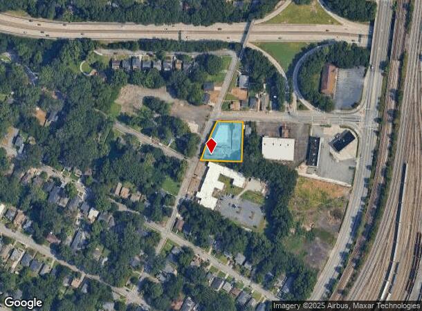
Property Record
2130 Newnan St, Atlanta, GA 30344
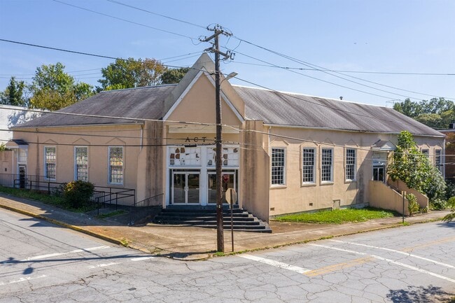
This Property Is For Sale
NEARBY LISTINGS FOR SALE OR LEASE
Property Detail
2130 Newnan St
Religious
Fulton
X
Georgia
13121C0358F
0.67 AC
2024
North Clayton/Airport
2025
Atlanta
011203
Atlanta-Sandy Springs-Roswell, GA
46,608 SF
14-0134-0005-052-6
DEMOGRAPHICS near 2130 Newnan St
1 Mile
3 Mile
5 Mile
2024 Total Population
7,275
90,090
224,681
2029 Population
7,616
93,569
235,001
Pop Growth 2024-2029
+ 4.69%
+ 3.86%
+ 4.59%
Average Age
38
39
38
2024 Total Households
3,239
38,222
93,021
HH Growth 2024-2029
+ 4.79%
+ 3.93%
+ 4.79%
Median Household Inc
$57,690
$45,490
$46,000
Avg Household Size
2.20
2.30
2.20
2024 Avg HH Vehicles
1.00
1.00
1.00
Median Home Value
$218,257
$247,316
$264,369
Median Year Built
1959
1962
1970
Nearby Places
- Restaurants
- Banks
- Shops
- Fitness
- Groceries
PUBLIC TRANSPORTATION
TRANSIT/SUBWAY
Lakewood/Ft Mcpherson (Gold Line - Metropolitan Atlanta Rapid Transit Authority (MARTA), Red Line - Metropolitan Atlanta Rapid Transit Authority (MARTA))
DRIVE
WALK
Distance
Lakewood/Ft Mcpherson (Gold Line - Metropolitan Atlanta Rapid Transit Authority (MARTA), Red Line - Metropolitan Atlanta Rapid Transit Authority (MARTA))
2 min
11 min
0.6 mi
AIRPORT
Hartsfield - Jackson Atlanta International
DRIVE
WALK
Distance
Hartsfield - Jackson Atlanta International
12 min
6.7 mi
Freight Ports
Georgia Ports - Savannah
DRIVE
WALK
Distance
Georgia Ports - Savannah
275 min
246.0 mi
Nearby Properties
Address
Land Use
TOTAL SIZE
Lot Size
Zoning
Address
Land Use
TOTAL SIZE
Lot Size
Zoning
11.74 AC
I1
Address
Land Use
TOTAL SIZE
Lot Size
Zoning
65,458 SF
174.39 AC
C1
Address
Land Use
TOTAL SIZE
Lot Size
Zoning
541,508 SF
110.88 AC
I1
Address
Land Use
TOTAL SIZE
Lot Size
Zoning
386,354 SF
10.03 AC
CR
Address
Land Use
TOTAL SIZE
Lot Size
Zoning
857,294 SF
101.10 AC
I1
Address
Land Use
TOTAL SIZE
Lot Size
Zoning
293,935 SF
8.47 AC
I2
Address
Land Use
TOTAL SIZE
Lot Size
Zoning
817,277 SF
21.04 AC
R3
Address
Land Use
TOTAL SIZE
Lot Size
Zoning
3,411,710 SF
25.97 AC
RG3
Address
Land Use
TOTAL SIZE
Lot Size
Zoning
382,918 SF
13.04 AC
CR
Address
Land Use
TOTAL SIZE
Lot Size
Zoning
425,270 SF
201.84 AC
I1
Address
Land Use
TOTAL SIZE
Lot Size
Zoning
668,070 SF
0.49 AC
C1
Address
Land Use
TOTAL SIZE
Lot Size
Zoning
3,268,352 SF
23.31 AC
RG2
Address
Land Use
TOTAL SIZE
Lot Size
Zoning
265,437 SF
4.74 AC
CL
Address
Land Use
TOTAL SIZE
Lot Size
Zoning
1,254,472 SF
0.49 AC
C1
Address
Land Use
TOTAL SIZE
Lot Size
Zoning
563,256 SF
22.69 AC
I1
Address
Land Use
TOTAL SIZE
Lot Size
Zoning
4.25 AC
R3
Address
Land Use
TOTAL SIZE
Lot Size
Zoning
6,834,480 SF
9.85 AC
RG3
Address
Land Use
TOTAL SIZE
Lot Size
Zoning
689,523 SF
34.32 AC
I1
Address
Land Use
TOTAL SIZE
Lot Size
Zoning
1,352,250 SF
3.18 AC
C2
Address
Land Use
TOTAL SIZE
Lot Size
Zoning
35.10 AC
R1
Address
Land Use
TOTAL SIZE
Lot Size
Zoning
193,760 SF
14.46 AC
CR
Address
Land Use
TOTAL SIZE
Lot Size
Zoning
2,963,779 SF
10.07 AC
C1
Address
Land Use
TOTAL SIZE
Lot Size
Zoning
508,896 SF
0.15 AC
CR
Address
Land Use
TOTAL SIZE
Lot Size
Zoning
54.47 AC
OI
Address
Land Use
TOTAL SIZE
Lot Size
Zoning
154,200 SF
3.09 AC
I2
Address
Land Use
TOTAL SIZE
Lot Size
Zoning
87,382 SF
83.24 AC
I1C
Address
Land Use
TOTAL SIZE
Lot Size
Zoning
39.06 AC
OI
Address
Land Use
TOTAL SIZE
Lot Size
Zoning
836,904 SF
3.91 AC
CR
Address
Land Use
TOTAL SIZE
Lot Size
Zoning
8.30 AC
I1
Address
Land Use
TOTAL SIZE
Lot Size
Zoning
279,108 SF
6.06 AC
C2
The World's #1 Commercial Real Estate Marketplace
Connect with us
© 2025 CoStar Group
The information above has been obtained from sources believed reliable. While we do not doubt its accuracy we have not verified it and make no guarantee, warranty or representation about it. It is your responsibility to independently confirm its accuracy and completeness. Any projections, opinions, assumptions, or estimates used are for example only and do not represent the current or future performance of the property. The value of this transaction to you depends on tax and other factors which should be evaluated by your tax, financial, and legal advisors. You and your advisors should conduct a careful, independent investigation of the property to determine to your satisfaction the suitability of the property for your needs.