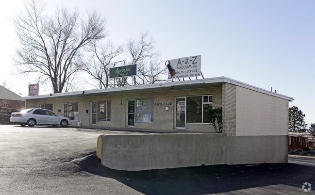
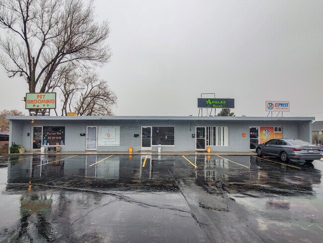
Property Record
2110 S Orchard Dr, Bountiful, UT 84010
NEARBY LISTINGS FOR SALE OR LEASE
Property Detail
2110 S Orchard Dr
05-002-0125
BEG AT A PT N 50^56'04" W 2115.82 FT FR THE E 1/4 COR OF SEC 31-T2N-R1E, SLB&M; & RUN TH N 85^26' W 437.06 FT; TH S 29^03'15" W 231.52 FT; TH S 86^10'15" E 462.69 FT TO THE W LINE OF A STR; TH N 23^32
Storebuilding
Davis
X
Utah
49011C0507F
2.05 AC
2025
Davis/Weber Counties
2025
Salt Lake City
126902
Ogden, UT
2,400 SF
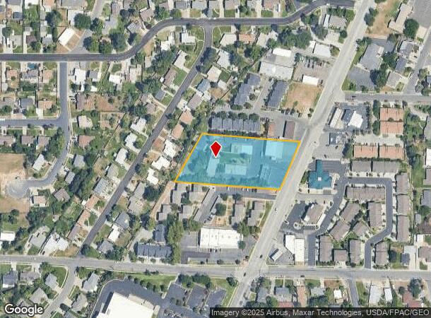
DEMOGRAPHICS near 2110 S Orchard Dr
1 Mile
3 Mile
5 Mile
2024 Total Population
15,527
78,445
100,176
2029 Population
16,340
82,570
105,430
Pop Growth 2024-2029
+ 5.24%
+ 5.26%
+ 5.24%
Average Age
38
37
37
2024 Total Households
5,403
25,919
33,105
HH Growth 2024-2029
+ 5.26%
+ 5.32%
+ 5.31%
Median Household Inc
$84,549
$92,494
$94,783
Avg Household Size
2.80
3.00
3.00
2024 Avg HH Vehicles
2.00
2.00
2.00
Median Home Value
$424,251
$461,161
$459,899
Median Year Built
1971
1978
1982
Nearby Places
Map Layers
Map Styles
 Street
 Aerial
- Restaurants
- Banks
- Shops
- Fitness
- Groceries
PUBLIC TRANSPORTATION
COMMUTER RAIL
Woods Cross (FrontRunner North - Utah Transit Authority (UTA))
DRIVE
WALK
Distance
Woods Cross (FrontRunner North - Utah Transit Authority (UTA))
6 min
2.5 mi
Warm Springs Relief Point (FrontRunner - Utah Transit Authority (UTA))
DRIVE
WALK
Distance
Warm Springs Relief Point (FrontRunner - Utah Transit Authority (UTA))
13 min
7.5 mi
AIRPORT
Salt Lake City International
DRIVE
WALK
Distance
Salt Lake City International
18 min
12.7 mi
Freight Ports
Port of Stockton
DRIVE
WALK
Distance
Port of Stockton
719 min
703.1 mi
SALE & LEASE HISTORY
LISTING DATE
SALE/LEASE

Nov 30, 2023
For Lease
Jun 20, 2019
For Lease
Feb 21, 2017
For Lease
Nearby Properties
Address
Land Use
TOTAL SIZE
Lot Size
Zoning
Address
Land Use
TOTAL SIZE
Lot Size
Zoning
123,416 SF
14.85 AC
R4
Address
Land Use
TOTAL SIZE
Lot Size
Zoning
181,804 SF
24.72 AC
Address
Land Use
TOTAL SIZE
Lot Size
Zoning
83,092 SF
9.07 AC
R3
Address
Land Use
TOTAL SIZE
Lot Size
Zoning
240,104 SF
37.03 AC
C2
Address
Land Use
TOTAL SIZE
Lot Size
Zoning
657,526 SF
35.95 AC
MD
Address
Land Use
TOTAL SIZE
Lot Size
Zoning
4,241 SF
8.67 AC
P
Address
Land Use
TOTAL SIZE
Lot Size
Zoning
3,026 SF
14.42 AC
P
Address
Land Use
TOTAL SIZE
Lot Size
Zoning
13,126 SF
7.83 AC
P
Address
Land Use
TOTAL SIZE
Lot Size
Zoning
168,369 SF
10.14 AC
H
Address
Land Use
TOTAL SIZE
Lot Size
Zoning
113,419 SF
16.45 AC
R4
Address
Land Use
TOTAL SIZE
Lot Size
Zoning
92,796 SF
2.22 AC
DN
Address
Land Use
TOTAL SIZE
Lot Size
Zoning
113,265 SF
0.55 AC
CG
Address
Land Use
TOTAL SIZE
Lot Size
Zoning
230,020 SF
27.33 AC
MD
Address
Land Use
TOTAL SIZE
Lot Size
Zoning
156,694 SF
7.67 AC
Address
Land Use
TOTAL SIZE
Lot Size
Zoning
167,410 SF
12.89 AC
CG
Address
Land Use
TOTAL SIZE
Lot Size
Zoning
259,942 SF
18.52 AC
MD
Address
Land Use
TOTAL SIZE
Lot Size
Zoning
155,896 SF
8.96 AC
Address
Land Use
TOTAL SIZE
Lot Size
Zoning
58,273 SF
3.80 AC
I1
Address
Land Use
TOTAL SIZE
Lot Size
Zoning
280,221 SF
30.36 AC
R4
Address
Land Use
TOTAL SIZE
Lot Size
Zoning
19,299 SF
3.06 AC
Address
Land Use
TOTAL SIZE
Lot Size
Zoning
113,197 SF
3.62 AC
Address
Land Use
TOTAL SIZE
Lot Size
Zoning
3,986 SF
13 AC
CG
Address
Land Use
TOTAL SIZE
Lot Size
Zoning
119,710 SF
13.15 AC
R4
Address
Land Use
TOTAL SIZE
Lot Size
Zoning
6,050 SF
59.94 AC
Address
Land Use
TOTAL SIZE
Lot Size
Zoning
146,381 SF
18.50 AC
PFL
Address
Land Use
TOTAL SIZE
Lot Size
Zoning
101,110 SF
8.12 AC
Address
Land Use
TOTAL SIZE
Lot Size
Zoning
57,830 SF
3.54 AC
Address
Land Use
TOTAL SIZE
Lot Size
Zoning
9,747 SF
7.73 AC
R4
Address
Land Use
TOTAL SIZE
Lot Size
Zoning
37,334 SF
9.72 AC
RM19
Address
Land Use
TOTAL SIZE
Lot Size
Zoning
166.84 AC
R-F
The World's #1 Commercial Real Estate Marketplace
Connect with us
© 2026 CoStar Group
The information above has been obtained from sources believed reliable. While we do not doubt its accuracy we have not verified it and make no guarantee, warranty or representation about it. It is your responsibility to independently confirm its accuracy and completeness. Any projections, opinions, assumptions, or estimates used are for example only and do not represent the current or future performance of the property. The value of this transaction to you depends on tax and other factors which should be evaluated by your tax, financial, and legal advisors. You and your advisors should conduct a careful, independent investigation of the property to determine to your satisfaction the suitability of the property for your needs.