Property Record
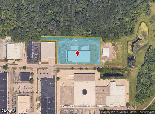
2130 W Badger Rd, Madison, WI 53713
NEARBY LISTINGS FOR SALE OR LEASE
-
-
-
-
-
No Photo
-
View all Madison listings for sale on LoopNet.com
Property Detail
2130 W Badger Rd
Madison, WI
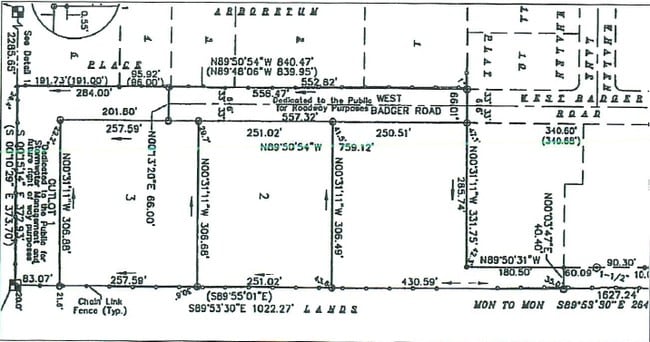
Certified Survey Map No 13516 As
0709-343-1305-1
CERTIFIED SURVEY MAP NO 13516 AS RECORDED IN DANE COUNTY REGISTER OF DEEDS IN VO L 88 PAGE 116 OF CERTIFIED SURVEYS, LOT 1.
Commercialnec
Dane
X
Wisconsin
55025C0416G
88
2024
3.70 AC
2024
Near West Madison
001402
Milwaukee/Madison
30,000 SF
DEMOGRAPHICS near 2130 W Badger Rd
1 Mile
3 Mile
5 Mile
2024 Total Population
9,271
113,671
201,039
2029 Population
9,598
116,889
207,504
Pop Growth 2024-2029
+ 3.53%
+ 2.83%
+ 3.22%
Average Age
34
34
36
2024 Total Households
4,105
47,599
89,152
HH Growth 2024-2029
+ 3.70%
+ 3.15%
+ 3.47%
Median Household Inc
$48,817
$58,647
$65,389
Avg Household Size
2.20
2.10
2.10
2024 Avg HH Vehicles
1.00
1.00
1.00
Median Home Value
$247,972
$379,087
$359,543
Median Year Built
1980
1975
1976
Nearby Places
Map Layers
Map Styles
 Street
 Aerial
- Restaurants
- Banks
- Shops
- Fitness
- Groceries
PUBLIC TRANSPORTATION
AIRPORT
Dane County Regional/Truax Field
DRIVE
WALK
Distance
Dane County Regional/Truax Field
22 min
11.0 mi
Freight Ports
Port Milwaukee
DRIVE
WALK
Distance
Port Milwaukee
102 min
85.5 mi
Nearby Properties
Address
Land Use
TOTAL SIZE
Lot Size
Zoning
Address
Land Use
TOTAL SIZE
Lot Size
Zoning
484,764 SF
1.62 AC
DC
Address
Land Use
TOTAL SIZE
Lot Size
Zoning
395,505 SF
0.99 AC
UMX
Address
Land Use
TOTAL SIZE
Lot Size
Zoning
8.42 AC
Address
Land Use
TOTAL SIZE
Lot Size
Zoning
466,963 SF
761.23 AC
PD
Address
Land Use
TOTAL SIZE
Lot Size
Zoning
21.49 AC
Address
Land Use
TOTAL SIZE
Lot Size
Zoning
463,006 SF
1.43 AC
UMX
Address
Land Use
TOTAL SIZE
Lot Size
Zoning
208,251 SF
414.76 AC
PD
Address
Land Use
TOTAL SIZE
Lot Size
Zoning
169,224 SF
5.49 AC
CC-T
Address
Land Use
TOTAL SIZE
Lot Size
Zoning
460,603 SF
1.08 AC
PD
Address
Land Use
TOTAL SIZE
Lot Size
Zoning
280,769 SF
0.80 AC
UMX
Address
Land Use
TOTAL SIZE
Lot Size
Zoning
590,387 SF
1.82 AC
PD
Address
Land Use
TOTAL SIZE
Lot Size
Zoning
18.97 AC
Address
Land Use
TOTAL SIZE
Lot Size
Zoning
230,268 SF
0.87 AC
UMX
Address
Land Use
TOTAL SIZE
Lot Size
Zoning
183,407 SF
2.71 AC
PD
Address
Land Use
TOTAL SIZE
Lot Size
Zoning
2.97 AC
Address
Land Use
TOTAL SIZE
Lot Size
Zoning
230,504 SF
0.76 AC
PD
Address
Land Use
TOTAL SIZE
Lot Size
Zoning
14,229 SF
0.50 AC
DC
Address
Land Use
TOTAL SIZE
Lot Size
Zoning
254,812 SF
0.64 AC
PD
Address
Land Use
TOTAL SIZE
Lot Size
Zoning
182,821 SF
1.19 AC
PD
Address
Land Use
TOTAL SIZE
Lot Size
Zoning
172,984 SF
1.59 AC
PD
Address
Land Use
TOTAL SIZE
Lot Size
Zoning
42,240 SF
0.98 AC
DC
Address
Land Use
TOTAL SIZE
Lot Size
Zoning
160,531 SF
0.41 AC
UMX
Address
Land Use
TOTAL SIZE
Lot Size
Zoning
6.30 AC
Address
Land Use
TOTAL SIZE
Lot Size
Zoning
Address
Land Use
TOTAL SIZE
Lot Size
Zoning
14.47 AC
Address
Land Use
TOTAL SIZE
Lot Size
Zoning
24.62 AC
Address
Land Use
TOTAL SIZE
Lot Size
Zoning
3.21 AC
Address
Land Use
TOTAL SIZE
Lot Size
Zoning
404,794 SF
4.86 AC
CC-T
Address
Land Use
TOTAL SIZE
Lot Size
Zoning
234,075 SF
0.80 AC
UMX
Address
Land Use
TOTAL SIZE
Lot Size
Zoning
169,491 SF
0.79 AC
HIS-L
The World's #1 Commercial Real Estate Marketplace
Connect with us
© 2025 CoStar Group
The information above has been obtained from sources believed reliable. While we do not doubt its accuracy we have not verified it and make no guarantee, warranty or representation about it. It is your responsibility to independently confirm its accuracy and completeness. Any projections, opinions, assumptions, or estimates used are for example only and do not represent the current or future performance of the property. The value of this transaction to you depends on tax and other factors which should be evaluated by your tax, financial, and legal advisors. You and your advisors should conduct a careful, independent investigation of the property to determine to your satisfaction the suitability of the property for your needs.