Property Record
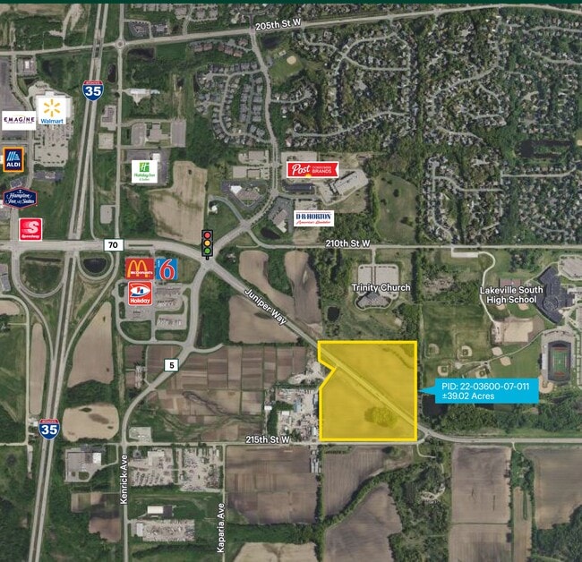
21300 Juniper Way, Lakeville, MN 55044

NEARBY LISTINGS FOR SALE OR LEASE
Property Detail
21300 Juniper Way
Minneapolis-St. Paul-Bloomington, MN-WI
Dakota
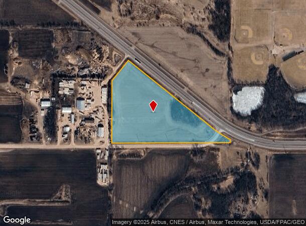
22-03600-07-011
Minnesota
Ruralagriculturalresidence
39.08 AC
AE
Dakota County Outlying
27037C0194E
Minneapolis/St Paul
DEMOGRAPHICS near 21300 Juniper Way
1 Mile
3 Mile
5 Mile
2024 Total Population
2,288
23,851
53,959
2029 Population
2,402
25,534
57,920
Pop Growth 2024-2029
+ 4.98%
+ 7.06%
+ 7.34%
Average Age
37
37
38
2024 Total Households
704
7,897
18,199
HH Growth 2024-2029
+ 5.26%
+ 7.18%
+ 7.48%
Median Household Inc
$137,500
$126,497
$128,866
Avg Household Size
3.20
3.00
2.90
2024 Avg HH Vehicles
2.00
2.00
2.00
Median Home Value
$417,021
$427,569
$432,255
Median Year Built
1997
2000
1999
Nearby Places
- Restaurants
- Banks
- Shops
- Fitness
- Groceries
PUBLIC TRANSPORTATION
AIRPORT
Minneapolis-St Paul International/Wold-Chamberlain
DRIVE
WALK
Distance
Minneapolis-St Paul International/Wold-Chamberlain
28 min
21.4 mi
Freight Ports
Port Milwaukee
DRIVE
WALK
Distance
Port Milwaukee
383 min
344.9 mi
SALE & LEASE HISTORY
LISTING DATE
SALE/LEASE

Sep 01, 2022
For Sale
Nearby Properties
Address
Land Use
TOTAL SIZE
Lot Size
Zoning
Address
Land Use
TOTAL SIZE
Lot Size
Zoning
749,550 SF
71.74 AC
Address
Land Use
TOTAL SIZE
Lot Size
Zoning
512,208 SF
90.38 AC
Address
Land Use
TOTAL SIZE
Lot Size
Zoning
355,380 SF
75.32 AC
Address
Land Use
TOTAL SIZE
Lot Size
Zoning
292,384 SF
39.16 AC
Address
Land Use
TOTAL SIZE
Lot Size
Zoning
342,606 SF
18.21 AC
Address
Land Use
TOTAL SIZE
Lot Size
Zoning
245,486 SF
5.29 AC
Address
Land Use
TOTAL SIZE
Lot Size
Zoning
107,036 SF
1.51 AC
Address
Land Use
TOTAL SIZE
Lot Size
Zoning
146,451 SF
10.63 AC
Address
Land Use
TOTAL SIZE
Lot Size
Zoning
179,859 SF
43.48 AC
Address
Land Use
TOTAL SIZE
Lot Size
Zoning
282,100 SF
18.86 AC
Address
Land Use
TOTAL SIZE
Lot Size
Zoning
374,622 SF
18.74 AC
Address
Land Use
TOTAL SIZE
Lot Size
Zoning
172,249 SF
69.47 AC
Address
Land Use
TOTAL SIZE
Lot Size
Zoning
157,593 SF
11.10 AC
Address
Land Use
TOTAL SIZE
Lot Size
Zoning
168,000 SF
14.31 AC
Address
Land Use
TOTAL SIZE
Lot Size
Zoning
187,993 SF
21.88 AC
Address
Land Use
TOTAL SIZE
Lot Size
Zoning
276,560 SF
20.11 AC
Address
Land Use
TOTAL SIZE
Lot Size
Zoning
121,600 SF
27.55 AC
Address
Land Use
TOTAL SIZE
Lot Size
Zoning
275,666 SF
23.58 AC
Address
Land Use
TOTAL SIZE
Lot Size
Zoning
158,698 SF
8.59 AC
Address
Land Use
TOTAL SIZE
Lot Size
Zoning
130,180 SF
9.01 AC
Address
Land Use
TOTAL SIZE
Lot Size
Zoning
151,109 SF
14.55 AC
Address
Land Use
TOTAL SIZE
Lot Size
Zoning
53,022 SF
11.89 AC
Address
Land Use
TOTAL SIZE
Lot Size
Zoning
109,440 SF
8.92 AC
Address
Land Use
TOTAL SIZE
Lot Size
Zoning
93,883 SF
4.17 AC
Address
Land Use
TOTAL SIZE
Lot Size
Zoning
210,012 SF
12.51 AC
Address
Land Use
TOTAL SIZE
Lot Size
Zoning
78,220 SF
5.96 AC
Address
Land Use
TOTAL SIZE
Lot Size
Zoning
112,730 SF
5.73 AC
Address
Land Use
TOTAL SIZE
Lot Size
Zoning
131,634 SF
10.76 AC
Address
Land Use
TOTAL SIZE
Lot Size
Zoning
56,950 SF
27.71 AC
Address
Land Use
TOTAL SIZE
Lot Size
Zoning
84,582 SF
14.20 AC
The World's #1 Commercial Real Estate Marketplace
Connect with us
© 2025 CoStar Group
The information above has been obtained from sources believed reliable. While we do not doubt its accuracy we have not verified it and make no guarantee, warranty or representation about it. It is your responsibility to independently confirm its accuracy and completeness. Any projections, opinions, assumptions, or estimates used are for example only and do not represent the current or future performance of the property. The value of this transaction to you depends on tax and other factors which should be evaluated by your tax, financial, and legal advisors. You and your advisors should conduct a careful, independent investigation of the property to determine to your satisfaction the suitability of the property for your needs.