Property Record
21306 E Arrow Hwy, Covina, CA 91724
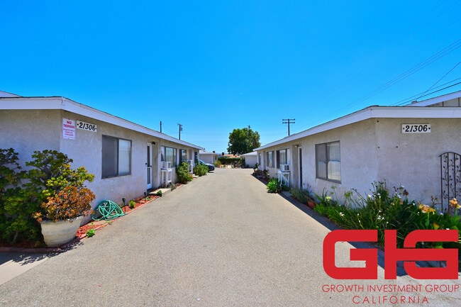

This Property Is For Sale
Property Detail
21306 E Arrow Hwy
8401-021-060
SUBDIVISION OF THE RANCHO ADDITION TO SAN JOSE AND A PORTION OF RANCHO SAN JOSE W 200 FT OF S 173.5 FT OF N 350 FT OF NE 1/4 OF NE 1/4 OF NE 1/4 OF SEC 8 T 1S R 9W
Multifamilydwelling
LOS ANGELES
LCC4*
California
B and X Area of moderate flood hazard, usually the area between the limits of the 100-year and 500-year floods.
8
2025
0.80 AC
2025
Charter Oak
403802
Los Angeles
14,960 SF
Los Angeles-Long Beach-Glendale, CA
NEARBY LISTINGS FOR SALE OR LEASE
DEMOGRAPHICS near 21306 E Arrow Hwy
1 mile
3 mile
5 mile
2025 Total Population
20,186
129,326
306,188
2030 Population
19,986
127,863
303,457
Pop Growth 2025-2030
(0.99%)
(1.13%)
(0.89%)
Average Age
43
42
41
2025 Total Households
6,783
43,401
96,746
HH Growth 2025-2030
(1.27%)
(1.41%)
(1.14%)
Median Household Inc
$98,837
$103,651
$99,537
Avg Household Size
2.90
2.90
3.00
2025 Avg HH Vehicles
2.00
2.00
2.00
Median Home Value
$670,430
$762,780
$757,983
Median Year Built
1972
1967
1967
Nearby Places
Map Layers
Map Styles
 Street
 Aerial
Layers
 Traffic
 Biking
Places
Listings with unknown addresses are not visible on the map
- Restaurants
- Banks
- Shops
- Fitness
- Groceries
PUBLIC TRANSPORTATION
COMMUTER RAIL
Covina (San Bernardino Line - Southern California Regional Rail Authority (Metrolink))
Drive
Walk
Distance
Covina (San Bernardino Line - Southern California Regional Rail Authority (Metrolink))
8 min
4.3 mi
Pomona (North) (San Bernardino Line - Southern California Regional Rail Authority (Metrolink))
Drive
Walk
Distance
Pomona (North) (San Bernardino Line - Southern California Regional Rail Authority (Metrolink))
10 min
5.9 mi
AIRPORT
Ontario International
Drive
Walk
Distance
Ontario International
24 min
17.4 mi
Long Beach (Daugherty Field)
Drive
Walk
Distance
Long Beach (Daugherty Field)
47 min
34.8 mi
John Wayne/Orange County
Drive
Walk
Distance
John Wayne/Orange County
42 min
35.0 mi
Freight Ports
Port of Long Beach
Drive
Walk
Distance
Port of Long Beach
53 min
40.5 mi
Nearby Properties
Address
Land Use
TOTAL SIZE
Lot Size
Zoning
Address
Land Use
TOTAL SIZE
Lot Size
Zoning
533,650 SF
5.27 AC
GDCM
Address
Land Use
TOTAL SIZE
Lot Size
Zoning
190,824 SF
8.21 AC
WCR3-MF20*
Address
Land Use
TOTAL SIZE
Lot Size
Zoning
173,240 SF
13.53 AC
SDMF15*
Address
Land Use
TOTAL SIZE
Lot Size
Zoning
110,640 SF
2.94 AC
GDMS
Address
Land Use
TOTAL SIZE
Lot Size
Zoning
141,780 SF
7.76 AC
CVRD
Address
Land Use
TOTAL SIZE
Lot Size
Zoning
151,267 SF
8.26 AC
SDM1*
Address
Land Use
TOTAL SIZE
Lot Size
Zoning
108,544 SF
6.24 AC
LCC4*
Address
Land Use
TOTAL SIZE
Lot Size
Zoning
90,786 SF
1.66 AC
CVE5 & PCD
Address
Land Use
TOTAL SIZE
Lot Size
Zoning
90,009 SF
6.22 AC
SDAP*
Address
Land Use
TOTAL SIZE
Lot Size
Zoning
110,364 SF
6.48 AC
GDC3
Address
Land Use
TOTAL SIZE
Lot Size
Zoning
66,831 SF
6.01 AC
GDC_RT66SP
Address
Land Use
TOTAL SIZE
Lot Size
Zoning
154,844 SF
13.73 AC
Address
Land Use
TOTAL SIZE
Lot Size
Zoning
94,446 SF
4.97 AC
CVA1PCD*
Address
Land Use
TOTAL SIZE
Lot Size
Zoning
217,976 SF
6.77 AC
SDM1*
Address
Land Use
TOTAL SIZE
Lot Size
Zoning
142,820 SF
7.28 AC
SDMF20000*
Address
Land Use
TOTAL SIZE
Lot Size
Zoning
76,220 SF
2.85 AC
AZR3B*
Address
Land Use
TOTAL SIZE
Lot Size
Zoning
160,160 SF
8.32 AC
GDR3
Address
Land Use
TOTAL SIZE
Lot Size
Zoning
195,523 SF
5.04 AC
GDMS*
Address
Land Use
TOTAL SIZE
Lot Size
Zoning
106,060 SF
2.59 AC
GDCM
Address
Land Use
TOTAL SIZE
Lot Size
Zoning
63,600 SF
4.58 AC
CVC3A*
Address
Land Use
TOTAL SIZE
Lot Size
Zoning
54,977 SF
4.26 AC
SDM1*
Address
Land Use
TOTAL SIZE
Lot Size
Zoning
157,624 SF
8.10 AC
SDMF20*
Address
Land Use
TOTAL SIZE
Lot Size
Zoning
205,948 SF
4.93 AC
SDM1*
Address
Land Use
TOTAL SIZE
Lot Size
Zoning
307,626 SF
6.72 AC
GDPR*
Address
Land Use
TOTAL SIZE
Lot Size
Zoning
158,315 SF
11.72 AC
GDPR
Address
Land Use
TOTAL SIZE
Lot Size
Zoning
114,709 SF
1.31 AC
GDPR
Address
Land Use
TOTAL SIZE
Lot Size
Zoning
57,438 SF
3.21 AC
LCR326U*
Address
Land Use
TOTAL SIZE
Lot Size
Zoning
57,420 SF
6.79 AC
CVCP
Address
Land Use
TOTAL SIZE
Lot Size
Zoning
87,210 SF
5.47 AC
SDM1
Address
Land Use
TOTAL SIZE
Lot Size
Zoning
48,352 SF
3.92 AC
SDMF15*
The World's #1 Commercial Real Estate Marketplace
Connect with us
© 2026 CoStar Group
The information above has been obtained from sources believed reliable. While we do not doubt its accuracy we have not verified it and make no guarantee, warranty or representation about it. It is your responsibility to independently confirm its accuracy and completeness. Any projections, opinions, assumptions, or estimates used are for example only and do not represent the current or future performance of the property. The value of this transaction to you depends on tax and other factors which should be evaluated by your tax, financial, and legal advisors. You and your advisors should conduct a careful, independent investigation of the property to determine to your satisfaction the suitability of the property for your needs.