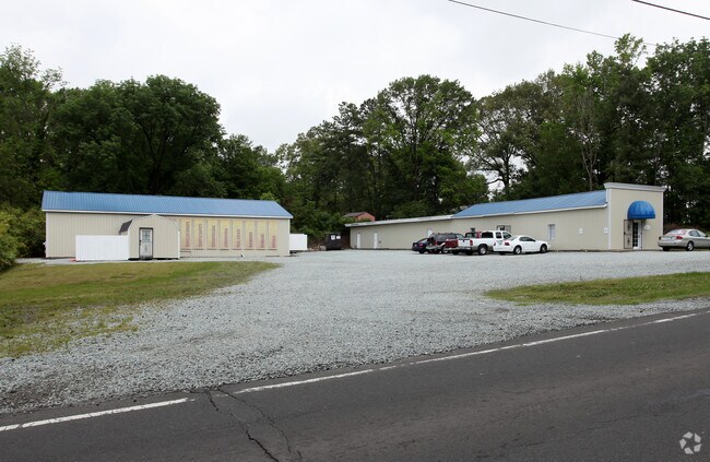
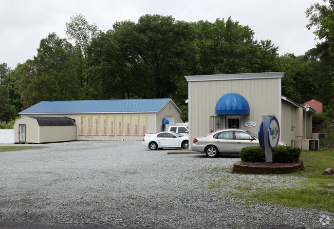
Property Record
2131 E Geer St, Durham, NC 27704


Property Detail
2131 E Geer St
169689
PROP-COLE K B/DBA-TRIANGL E SIGN/LT#47-50 INCL PL:000015-000078
Multipleuses
Durham
CN
North Carolina
B and X Area of moderate flood hazard, usually the area between the limits of the 100-year and 500-year floods.
47,50
2024
0.46 AC
2025
North Durham
001801
Raleigh/Durham
2,772 SF
Durham-Chapel Hill, NC
NEARBY LISTINGS FOR SALE OR LEASE
DEMOGRAPHICS near 2131 E Geer St
1 mile
3 mile
5 mile
2024 Total Population
2,756
48,949
143,038
2029 Population
2,933
51,830
151,907
Pop Growth 2024-2029
+ 6.42%
+ 5.89%
+ 6.20%
Average Age
37
37
37
2024 Total Households
917
17,743
54,561
HH Growth 2024-2029
+ 6.54%
+ 6.07%
+ 6.67%
Median Household Inc
$68,011
$71,575
$70,742
Avg Household Size
2.90
2.60
2.40
2024 Avg HH Vehicles
2.00
2.00
2.00
Median Home Value
$278,723
$320,036
$362,475
Median Year Built
1996
1984
1985
Nearby Places
Map Layers
Map Styles
 Street
 Aerial
Transit
 Traffic
 Biking
Places
Listings with unknown addresses are not visible on the map
- Restaurants
- Banks
- Shops
- Fitness
- Groceries
Nearby Properties
Address
Land Use
TOTAL SIZE
Lot Size
Zoning
Address
Land Use
TOTAL SIZE
Lot Size
Zoning
69.37 AC
IL
Address
Land Use
TOTAL SIZE
Lot Size
Zoning
40.81 AC
IL
Address
Land Use
TOTAL SIZE
Lot Size
Zoning
15.47 AC
RS-M(D)
Address
Land Use
TOTAL SIZE
Lot Size
Zoning
354,480 SF
34.53 AC
IL
Address
Land Use
TOTAL SIZE
Lot Size
Zoning
8.12 AC
RS-M
Address
Land Use
TOTAL SIZE
Lot Size
Zoning
15,720 SF
16.18 AC
PDR 10.000
Address
Land Use
TOTAL SIZE
Lot Size
Zoning
98,638 SF
24.59 AC
IL
Address
Land Use
TOTAL SIZE
Lot Size
Zoning
17,088 SF
15.96 AC
PDR 10.000
Address
Land Use
TOTAL SIZE
Lot Size
Zoning
246,580 SF
15.74 AC
IL
Address
Land Use
TOTAL SIZE
Lot Size
Zoning
187,680 SF
38.82 AC
Address
Land Use
TOTAL SIZE
Lot Size
Zoning
149,577 SF
34.30 AC
CG(D)
Address
Land Use
TOTAL SIZE
Lot Size
Zoning
150,980 SF
2.20 AC
CG
Address
Land Use
TOTAL SIZE
Lot Size
Zoning
242,250 SF
24.73 AC
IL
Address
Land Use
TOTAL SIZE
Lot Size
Zoning
432 SF
13.29 AC
RS-M
Address
Land Use
TOTAL SIZE
Lot Size
Zoning
91,791 SF
6.41 AC
PDR 8.000
Address
Land Use
TOTAL SIZE
Lot Size
Zoning
159,126 SF
21.53 AC
IL
Address
Land Use
TOTAL SIZE
Lot Size
Zoning
42,297 SF
27.40 AC
IL
Address
Land Use
TOTAL SIZE
Lot Size
Zoning
8,392 SF
12.89 AC
PDR 9.800
Address
Land Use
TOTAL SIZE
Lot Size
Zoning
11,787 SF
10.01 AC
PDR 10.000
Address
Land Use
TOTAL SIZE
Lot Size
Zoning
56,122 SF
4.87 AC
RU-5(2)
Address
Land Use
TOTAL SIZE
Lot Size
Zoning
17.26 AC
RS-M
Address
Land Use
TOTAL SIZE
Lot Size
Zoning
12,516 SF
9.45 AC
RS-M
Address
Land Use
TOTAL SIZE
Lot Size
Zoning
237,277 SF
20.37 AC
IL
Address
Land Use
TOTAL SIZE
Lot Size
Zoning
10,640 SF
12.11 AC
RS-M
Address
Land Use
TOTAL SIZE
Lot Size
Zoning
51,354 SF
18.78 AC
IL
Address
Land Use
TOTAL SIZE
Lot Size
Zoning
10,452 SF
7.57 AC
RS-M
Address
Land Use
TOTAL SIZE
Lot Size
Zoning
114,473 SF
7.02 AC
RS-8
Address
Land Use
TOTAL SIZE
Lot Size
Zoning
112,520 SF
13.28 AC
CC(D)
Address
Land Use
TOTAL SIZE
Lot Size
Zoning
79,890 SF
8.25 AC
OI(D)
Address
Land Use
TOTAL SIZE
Lot Size
Zoning
113,962 SF
10.98 AC
CC(D)
The World's #1 Commercial Real Estate Marketplace
Connect with us
© 2026 CoStar Group
The information above has been obtained from sources believed reliable. While we do not doubt its accuracy we have not verified it and make no guarantee, warranty or representation about it. It is your responsibility to independently confirm its accuracy and completeness. Any projections, opinions, assumptions, or estimates used are for example only and do not represent the current or future performance of the property. The value of this transaction to you depends on tax and other factors which should be evaluated by your tax, financial, and legal advisors. You and your advisors should conduct a careful, independent investigation of the property to determine to your satisfaction the suitability of the property for your needs.