Property Record
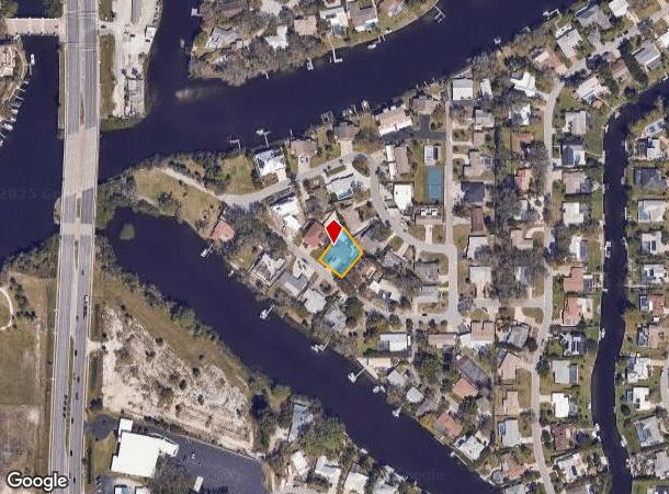
2131 Montclair Dr, Sarasota, FL 34231
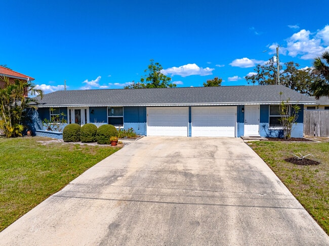
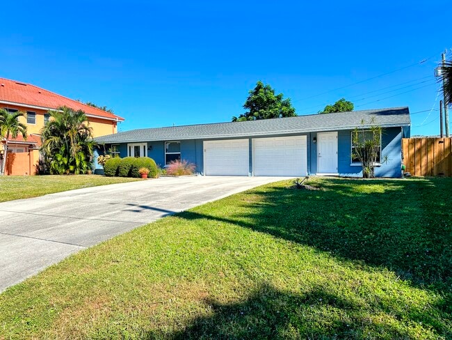
This Property Is For Sale
NEARBY LISTINGS FOR SALE OR LEASE
Property Detail
2131 Montclair Dr
North Port-Bradenton-Sarasota, FL
Monticello Unit 1
0086-12-0010
LOT 24 MONTICELLO UNIT 1
Duplex
Sarasota
X
Florida
12115C0144G
24
2024
0.24 AC
2025
South Sarasota
001805
Tampa/St Petersburg
1,785 SF
DEMOGRAPHICS near 2131 Montclair Dr
1 mile
3 mile
5 mile
2024 Total Population
8,766
65,788
156,970
2029 Population
10,902
81,941
194,491
Pop Growth 2024-2029
+ 24.37%
+ 24.55%
+ 23.90%
Average Age
52
51
51
2024 Total Households
4,287
31,574
74,993
HH Growth 2024-2029
+ 24.77%
+ 25.01%
+ 24.42%
Median Household Inc
$82,028
$82,203
$81,848
Avg Household Size
2.00
2.00
2.00
2024 Avg HH Vehicles
2.00
2.00
2.00
Median Home Value
$550,078
$580,809
$534,452
Median Year Built
1977
1975
1979
Nearby Places
Map Layers
Map Styles
 Street
 Aerial
Transit
 Traffic
 Biking
Places
Listings with unknown addresses are not visible on the map
- Restaurants
- Banks
- Shops
- Fitness
- Groceries
PUBLIC TRANSPORTATION
AIRPORT
Sarasota/Bradenton International
Drive
Walk
Distance
Sarasota/Bradenton International
22 min
10.6 mi
Nearby Properties
Address
Land Use
TOTAL SIZE
Lot Size
Zoning
Address
Land Use
TOTAL SIZE
Lot Size
Zoning
588,839 SF
42.33 AC
GU
Address
Land Use
TOTAL SIZE
Lot Size
Zoning
912,253 SF
43.46 AC
PID
Address
Land Use
TOTAL SIZE
Lot Size
Zoning
432,668 SF
72.05 AC
GU
Address
Land Use
TOTAL SIZE
Lot Size
Zoning
11,781 SF
43.95 AC
GU
Address
Land Use
TOTAL SIZE
Lot Size
Zoning
312,294 SF
40.21 AC
OPI
Address
Land Use
TOTAL SIZE
Lot Size
Zoning
332,822 SF
34.74 AC
CG
Address
Land Use
TOTAL SIZE
Lot Size
Zoning
150,433 SF
10.55 AC
RMF4
Address
Land Use
TOTAL SIZE
Lot Size
Zoning
157,854 SF
8.32 AC
OPI
Address
Land Use
TOTAL SIZE
Lot Size
Zoning
223,929 SF
28.24 AC
RMF1
Address
Land Use
TOTAL SIZE
Lot Size
Zoning
151,814 SF
10.89 AC
CSCC
Address
Land Use
TOTAL SIZE
Lot Size
Zoning
373,288 SF
53.07 AC
PID
Address
Land Use
TOTAL SIZE
Lot Size
Zoning
233,075 SF
19.49 AC
RMF2
Address
Land Use
TOTAL SIZE
Lot Size
Zoning
133,430 SF
19.60 AC
GU
Address
Land Use
TOTAL SIZE
Lot Size
Zoning
146,339 SF
12.54 AC
CG
Address
Land Use
TOTAL SIZE
Lot Size
Zoning
177,957 SF
19.36 AC
G
Address
Land Use
TOTAL SIZE
Lot Size
Zoning
140,372 SF
14.31 AC
CG
Address
Land Use
TOTAL SIZE
Lot Size
Zoning
123,338 SF
8.53 AC
OPI
Address
Land Use
TOTAL SIZE
Lot Size
Zoning
376,559 SF
26.52 AC
CSC
Address
Land Use
TOTAL SIZE
Lot Size
Zoning
96,425 SF
8.59 AC
OPI
Address
Land Use
TOTAL SIZE
Lot Size
Zoning
139,974 SF
6.07 AC
RMF4
Address
Land Use
TOTAL SIZE
Lot Size
Zoning
89,101 SF
8.42 AC
CGD
Address
Land Use
TOTAL SIZE
Lot Size
Zoning
184,766 SF
12.70 AC
RMF3
Address
Land Use
TOTAL SIZE
Lot Size
Zoning
20,192 SF
1.94 AC
RMF3
Address
Land Use
TOTAL SIZE
Lot Size
Zoning
81,166 SF
13.18 AC
GU
Address
Land Use
TOTAL SIZE
Lot Size
Zoning
77,568 SF
19 AC
RSF3
Address
Land Use
TOTAL SIZE
Lot Size
Zoning
86,102 SF
5.23 AC
RMF3
Address
Land Use
TOTAL SIZE
Lot Size
Zoning
118,913 SF
24.40 AC
GU
Address
Land Use
TOTAL SIZE
Lot Size
Zoning
67,363 SF
5.71 AC
CG
Address
Land Use
TOTAL SIZE
Lot Size
Zoning
12,662 SF
0.99 AC
RSF1
Address
Land Use
TOTAL SIZE
Lot Size
Zoning
7,872 SF
1.63 AC
RSF1
The World's #1 Commercial Real Estate Marketplace
Connect with us
© 2026 CoStar Group
The information above has been obtained from sources believed reliable. While we do not doubt its accuracy we have not verified it and make no guarantee, warranty or representation about it. It is your responsibility to independently confirm its accuracy and completeness. Any projections, opinions, assumptions, or estimates used are for example only and do not represent the current or future performance of the property. The value of this transaction to you depends on tax and other factors which should be evaluated by your tax, financial, and legal advisors. You and your advisors should conduct a careful, independent investigation of the property to determine to your satisfaction the suitability of the property for your needs.