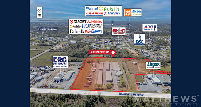
Property Record
2131 N East Ave, Panama City, FL 32405


NEARBY LISTINGS FOR SALE OR LEASE
-
-
View all Panama City listings for sale on LoopNet.com
Property Detail
2131 N East Ave
14660-120-000
34 3S 14W -43.12- 104D1 COM AT NE COR OF SEC TH W 702.90 TO SHERMAN AVE SWLY ALG R/W 400 TO S R/W 22ND CT E 876.15 TO EAST AV S ALG R/W 884.77 FOR POB TH W 625.65 TO W R/W GPCO R/W N 677.18 E 239.87 SELY 123.19 N 300.82 E 60 S 478.97 E 226.27 TO W R/
Warehouse
Bay
A
Florida
12005C0342J
7.65 AC
2023
Panama City
2024
Other Market Areas
001200
Panama City, FL
34,195 SF
DEMOGRAPHICS near 2131 N East Ave
1 Mile
3 Mile
5 Mile
2024 Total Population
3,180
35,125
81,551
2029 Population
3,385
37,630
86,333
Pop Growth 2024-2029
+ 6.45%
+ 7.13%
+ 5.86%
Average Age
36
39
40
2024 Total Households
1,147
13,346
31,398
HH Growth 2024-2029
+ 6.80%
+ 7.65%
+ 6.33%
Median Household Inc
$45,806
$51,769
$57,211
Avg Household Size
2.60
2.50
2.50
2024 Avg HH Vehicles
2.00
2.00
2.00
Median Home Value
$112,661
$175,128
$196,646
Median Year Built
1995
1986
1985
Nearby Places
Map Layers
Map Styles
 Street
 Aerial
- Restaurants
- Banks
- Shops
- Fitness
- Groceries
PUBLIC TRANSPORTATION
AIRPORT
Northwest Florida Beaches International
DRIVE
WALK
Distance
Northwest Florida Beaches International
35 min
21.6 mi
Freight Ports
Port of Panama City
DRIVE
WALK
Distance
Port of Panama City
14 min
7.5 mi
Nearby Properties
Address
Land Use
TOTAL SIZE
Lot Size
Zoning
Address
Land Use
TOTAL SIZE
Lot Size
Zoning
764,032 SF
12.80 AC
PC14
Address
Land Use
TOTAL SIZE
Lot Size
Zoning
477,423 SF
21.91 AC
PC09
Address
Land Use
TOTAL SIZE
Lot Size
Zoning
279,378 SF
13.24 AC
PC07
Address
Land Use
TOTAL SIZE
Lot Size
Zoning
226,068 SF
12.80 AC
Address
Land Use
TOTAL SIZE
Lot Size
Zoning
354,592 SF
24 AC
UND
Address
Land Use
TOTAL SIZE
Lot Size
Zoning
140,899 SF
15.48 AC
PC09
Address
Land Use
TOTAL SIZE
Lot Size
Zoning
415,651 SF
266 AC
BC13
Address
Land Use
TOTAL SIZE
Lot Size
Zoning
Address
Land Use
TOTAL SIZE
Lot Size
Zoning
115,056 SF
21 AC
PC09
Address
Land Use
TOTAL SIZE
Lot Size
Zoning
122,813 SF
9.58 AC
PC09
Address
Land Use
TOTAL SIZE
Lot Size
Zoning
424,813 SF
30 AC
Address
Land Use
TOTAL SIZE
Lot Size
Zoning
Address
Land Use
TOTAL SIZE
Lot Size
Zoning
115,472 SF
9.10 AC
Address
Land Use
TOTAL SIZE
Lot Size
Zoning
238,930 SF
39.18 AC
PSP
Address
Land Use
TOTAL SIZE
Lot Size
Zoning
207,286 SF
3.48 AC
PC10
Address
Land Use
TOTAL SIZE
Lot Size
Zoning
165,098 SF
9.67 AC
PC04
Address
Land Use
TOTAL SIZE
Lot Size
Zoning
81,774 SF
17.46 AC
PC05
Address
Land Use
TOTAL SIZE
Lot Size
Zoning
164,923 SF
23.60 AC
PC09
Address
Land Use
TOTAL SIZE
Lot Size
Zoning
350,458 SF
16.29 AC
UND
Address
Land Use
TOTAL SIZE
Lot Size
Zoning
224,823 SF
59.80 AC
PSP
Address
Land Use
TOTAL SIZE
Lot Size
Zoning
118,302 SF
8 AC
PC05
Address
Land Use
TOTAL SIZE
Lot Size
Zoning
256,570 SF
7 AC
PC14
Address
Land Use
TOTAL SIZE
Lot Size
Zoning
126,234 SF
20.02 AC
PI
Address
Land Use
TOTAL SIZE
Lot Size
Zoning
62,640 SF
0.48 AC
PC10
Address
Land Use
TOTAL SIZE
Lot Size
Zoning
98,827 SF
11.95 AC
PC09
Address
Land Use
TOTAL SIZE
Lot Size
Zoning
113,514 SF
14.51 AC
UND
Address
Land Use
TOTAL SIZE
Lot Size
Zoning
102,730 SF
11.12 AC
PC09
Address
Land Use
TOTAL SIZE
Lot Size
Zoning
36,866 SF
12 AC
PC14
Address
Land Use
TOTAL SIZE
Lot Size
Zoning
101,092 SF
10.27 AC
PC09
Address
Land Use
TOTAL SIZE
Lot Size
Zoning
92,299 SF
4.67 AC
The World's #1 Commercial Real Estate Marketplace
Connect with us
© 2026 CoStar Group
The information above has been obtained from sources believed reliable. While we do not doubt its accuracy we have not verified it and make no guarantee, warranty or representation about it. It is your responsibility to independently confirm its accuracy and completeness. Any projections, opinions, assumptions, or estimates used are for example only and do not represent the current or future performance of the property. The value of this transaction to you depends on tax and other factors which should be evaluated by your tax, financial, and legal advisors. You and your advisors should conduct a careful, independent investigation of the property to determine to your satisfaction the suitability of the property for your needs.