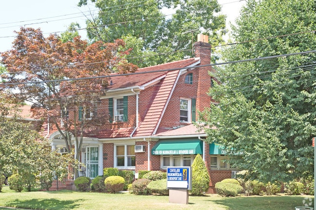
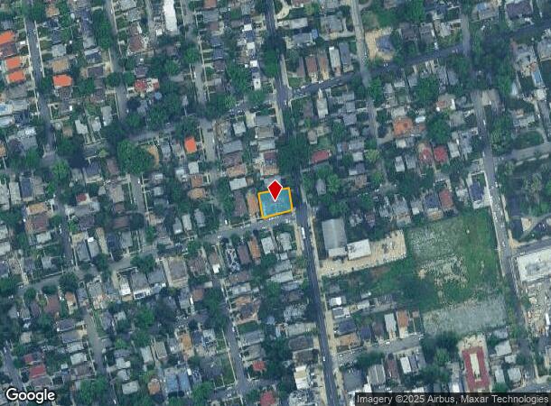
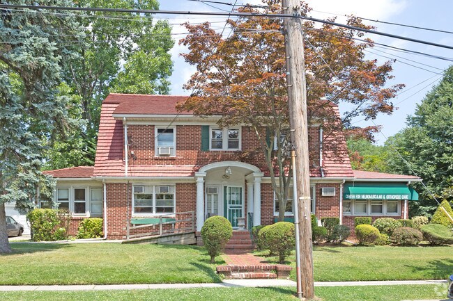
Property Record
21315 33Rd Rd, Bayside, NY 11361
NEARBY LISTINGS FOR SALE OR LEASE
Property Detail
21315 33Rd Rd
06113-0020
Queens
Commercialofficeresidentialmixeduse
New York
X
20
3604970119F
0.17 AC
2024
Northeast Queens
2025
Long Island (New York)
109700
New York-Jersey City-White Plains, NY-NJ
2,307 SF
DEMOGRAPHICS near 21315 33Rd Rd
1 mile
3 mile
5 mile
2024 Total Population
39,532
356,825
941,479
2029 Population
37,094
336,643
884,447
Pop Growth 2024-2029
(6.17%)
(5.66%)
(6.06%)
Average Age
47
45
43
2024 Total Households
15,967
130,136
323,389
HH Growth 2024-2029
(6.38%)
(5.98%)
(6.26%)
Median Household Inc
$87,588
$74,201
$76,165
Avg Household Size
2.40
2.60
2.80
2024 Avg HH Vehicles
1.00
1.00
1.00
Median Home Value
$749,324
$737,924
$713,786
Median Year Built
1960
1956
1955
Nearby Places
Map Layers
Map Styles
 Street
 Aerial
Transit
 Traffic
 Biking
Places
Listings with unknown addresses are not visible on the map
- Restaurants
- Banks
- Shops
- Fitness
- Groceries
PUBLIC TRANSPORTATION
TRANSIT/SUBWAY
Bayside Station (Port Washington Branch - Long Island Rail Road)
Drive
Walk
Distance
Bayside Station (Port Washington Branch - Long Island Rail Road)
2 min
16 min
0.7 mi
COMMUTER RAIL
Bayside Station (Port Washington Branch - Long Island Rail Road)
Drive
Walk
Distance
Bayside Station (Port Washington Branch - Long Island Rail Road)
2 min
12 min
0.6 mi
Auburndale Station (Port Washington Branch - Long Island Rail Road)
Drive
Walk
Distance
Auburndale Station (Port Washington Branch - Long Island Rail Road)
4 min
1.3 mi
AIRPORT
LaGuardia
Drive
Walk
Distance
LaGuardia
16 min
6.5 mi
John F Kennedy International
Drive
Walk
Distance
John F Kennedy International
20 min
12.7 mi
Westchester County
Drive
Walk
Distance
Westchester County
42 min
27.8 mi
Freight Ports
NY - Red Hook Container Terminal
Drive
Walk
Distance
NY - Red Hook Container Terminal
28 min
17.5 mi
Nearby Properties
Address
Land Use
TOTAL SIZE
Lot Size
Zoning
Address
Land Use
TOTAL SIZE
Lot Size
Zoning
2,697,663 SF
3.46 AC
C5-3
Address
Land Use
TOTAL SIZE
Lot Size
Zoning
1,666,696 SF
1.87 AC
C52.5
Address
Land Use
TOTAL SIZE
Lot Size
Zoning
7,975 SF
133 AC
PARK
Address
Land Use
TOTAL SIZE
Lot Size
Zoning
878,386 SF
20.55 AC
R4
Address
Land Use
TOTAL SIZE
Lot Size
Zoning
800 SF
104.61 AC
PARK
Address
Land Use
TOTAL SIZE
Lot Size
Zoning
703,265 SF
83.45 AC
R4
Address
Land Use
TOTAL SIZE
Lot Size
Zoning
421,996 SF
136.05 AC
R3-1
Address
Land Use
TOTAL SIZE
Lot Size
Zoning
554,300 SF
20.72 AC
R3-2
Address
Land Use
TOTAL SIZE
Lot Size
Zoning
554,300 SF
20.72 AC
R3-2
Address
Land Use
TOTAL SIZE
Lot Size
Zoning
4,050 SF
113.40 AC
PARK
Address
Land Use
TOTAL SIZE
Lot Size
Zoning
947 SF
101.82 AC
PARK
Address
Land Use
TOTAL SIZE
Lot Size
Zoning
4,800 SF
80.10 AC
PARK
Address
Land Use
TOTAL SIZE
Lot Size
Zoning
1,186,778 SF
31.45 AC
R4
Address
Land Use
TOTAL SIZE
Lot Size
Zoning
644,836 SF
14.26 AC
R5
Address
Land Use
TOTAL SIZE
Lot Size
Zoning
644,836 SF
14.26 AC
R5
Address
Land Use
TOTAL SIZE
Lot Size
Zoning
644,836 SF
14.26 AC
R5
Address
Land Use
TOTAL SIZE
Lot Size
Zoning
644,836 SF
14.26 AC
R5
Address
Land Use
TOTAL SIZE
Lot Size
Zoning
644,836 SF
14.26 AC
R5
Address
Land Use
TOTAL SIZE
Lot Size
Zoning
644,836 SF
14.26 AC
R5
Address
Land Use
TOTAL SIZE
Lot Size
Zoning
644,836 SF
14.26 AC
R5
Address
Land Use
TOTAL SIZE
Lot Size
Zoning
644,836 SF
14.26 AC
R5
Address
Land Use
TOTAL SIZE
Lot Size
Zoning
644,836 SF
14.26 AC
R5
Address
Land Use
TOTAL SIZE
Lot Size
Zoning
644,836 SF
14.26 AC
R5
Address
Land Use
TOTAL SIZE
Lot Size
Zoning
644,836 SF
14.26 AC
R5
Address
Land Use
TOTAL SIZE
Lot Size
Zoning
644,836 SF
14.26 AC
R5
Address
Land Use
TOTAL SIZE
Lot Size
Zoning
644,836 SF
14.26 AC
R5
Address
Land Use
TOTAL SIZE
Lot Size
Zoning
644,836 SF
14.26 AC
R5
Address
Land Use
TOTAL SIZE
Lot Size
Zoning
644,836 SF
14.26 AC
R5
Address
Land Use
TOTAL SIZE
Lot Size
Zoning
644,836 SF
14.26 AC
R5
Address
Land Use
TOTAL SIZE
Lot Size
Zoning
644,836 SF
14.26 AC
R5
The World's #1 Commercial Real Estate Marketplace
Connect with us
© 2026 CoStar Group
The information above has been obtained from sources believed reliable. While we do not doubt its accuracy we have not verified it and make no guarantee, warranty or representation about it. It is your responsibility to independently confirm its accuracy and completeness. Any projections, opinions, assumptions, or estimates used are for example only and do not represent the current or future performance of the property. The value of this transaction to you depends on tax and other factors which should be evaluated by your tax, financial, and legal advisors. You and your advisors should conduct a careful, independent investigation of the property to determine to your satisfaction the suitability of the property for your needs.