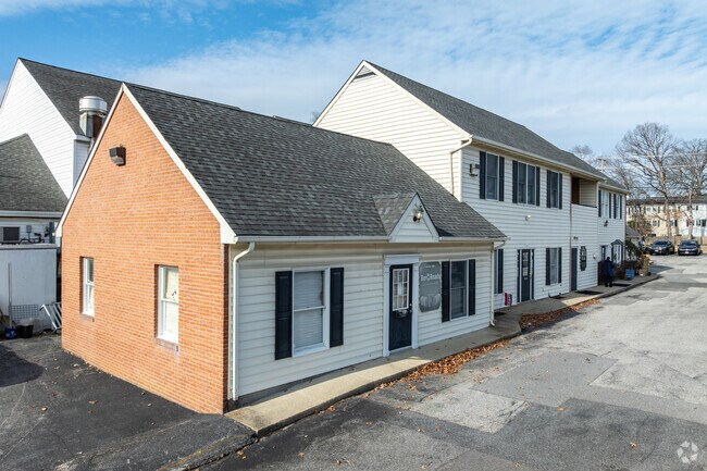
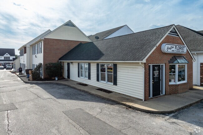
Property Record
2133 Defense Hwy, Crofton, MD 21114
NEARBY LISTINGS FOR SALE OR LEASE
Property Detail
2133 Defense Hwy
02-183-90076053
Crofton Depot Condo
Officecondo
UNIT 1 BLDG 2133 CROFTON DEPOT CONDO
X
Anne Arundel
24033C0180E
Maryland
2024
0.03 AC
2025
I-97/Crain Hwy Corridor
702300
Baltimore
1,096 SF
Baltimore-Columbia-Towson, MD
DEMOGRAPHICS near 2133 Defense Hwy
1 Mile
3 Mile
5 Mile
2024 Total Population
5,029
47,226
106,297
2029 Population
5,106
47,665
106,082
Pop Growth 2024-2029
+ 1.53%
+ 0.93%
(0.20%)
Average Age
40
40
41
2024 Total Households
1,768
17,202
37,853
HH Growth 2024-2029
+ 1.58%
+ 1.08%
(0.07%)
Median Household Inc
$154,714
$131,489
$132,062
Avg Household Size
2.80
2.70
2.70
2024 Avg HH Vehicles
2.00
2.00
2.00
Median Home Value
$558,915
$446,408
$441,955
Median Year Built
1975
1978
1987
Nearby Places
Map Layers
Map Styles
 Street
 Aerial
- Restaurants
- Banks
- Shops
- Fitness
- Groceries
PUBLIC TRANSPORTATION
COMMUTER RAIL
Bowie State Marc Nb (PENN - WASHINGTON - Maryland Transit Administration)
DRIVE
WALK
Distance
Bowie State Marc Nb (PENN - WASHINGTON - Maryland Transit Administration)
13 min
5.7 mi
Bowie State Marc Sb (PENN - WASHINGTON - Maryland Transit Administration)
DRIVE
WALK
Distance
Bowie State Marc Sb (PENN - WASHINGTON - Maryland Transit Administration)
13 min
7.1 mi
AIRPORT
Baltimore/Washington International Thurgood Marshall
DRIVE
WALK
Distance
Baltimore/Washington International Thurgood Marshall
29 min
19.1 mi
Ronald Reagan Washington Ntl
DRIVE
WALK
Distance
Ronald Reagan Washington Ntl
38 min
26.1 mi
Freight Ports
Port of Baltimore
DRIVE
WALK
Distance
Port of Baltimore
37 min
24.6 mi
Nearby Properties
Address
Land Use
TOTAL SIZE
Lot Size
Zoning
Address
Land Use
TOTAL SIZE
Lot Size
Zoning
444,842 SF
19.48 AC
R22
Address
Land Use
TOTAL SIZE
Lot Size
Zoning
246,000 SF
15.73 AC
MXDR
Address
Land Use
TOTAL SIZE
Lot Size
Zoning
273,816 SF
44.22 AC
MXD-C
Address
Land Use
TOTAL SIZE
Lot Size
Zoning
6.34 AC
TACE
Address
Land Use
TOTAL SIZE
Lot Size
Zoning
80,321 SF
11.78 AC
CGO
Address
Land Use
TOTAL SIZE
Lot Size
Zoning
287,439 SF
19.97 AC
CGO
Address
Land Use
TOTAL SIZE
Lot Size
Zoning
8.70 AC
R15
Address
Land Use
TOTAL SIZE
Lot Size
Zoning
120,560 SF
9 AC
TACE
Address
Land Use
TOTAL SIZE
Lot Size
Zoning
159,944 SF
5.34 AC
C1
Address
Land Use
TOTAL SIZE
Lot Size
Zoning
101,475 SF
11.17 AC
CGO
Address
Land Use
TOTAL SIZE
Lot Size
Zoning
166,720 SF
8.72 AC
TACE
Address
Land Use
TOTAL SIZE
Lot Size
Zoning
122,290 SF
3.14 AC
TACE
Address
Land Use
TOTAL SIZE
Lot Size
Zoning
8.38 AC
R22
Address
Land Use
TOTAL SIZE
Lot Size
Zoning
140 SF
5.47 AC
RMF20
Address
Land Use
TOTAL SIZE
Lot Size
Zoning
108,480 SF
17.66 AC
C4
Address
Land Use
TOTAL SIZE
Lot Size
Zoning
72,925 SF
4.12 AC
MXR
Address
Land Use
TOTAL SIZE
Lot Size
Zoning
114,327 SF
14.44 AC
TACE
Address
Land Use
TOTAL SIZE
Lot Size
Zoning
90,180 SF
6.48 AC
TACE
Address
Land Use
TOTAL SIZE
Lot Size
Zoning
47,744 SF
1.79 AC
MXD-C
Address
Land Use
TOTAL SIZE
Lot Size
Zoning
39,695 SF
11.66 AC
C4
Address
Land Use
TOTAL SIZE
Lot Size
Zoning
111,450 SF
154.81 AC
R1
Address
Land Use
TOTAL SIZE
Lot Size
Zoning
87,919 SF
9.71 AC
R5
Address
Land Use
TOTAL SIZE
Lot Size
Zoning
175,036 SF
9.44 AC
TACE
Address
Land Use
TOTAL SIZE
Lot Size
Zoning
29,161 SF
3.98 AC
MXD-C
Address
Land Use
TOTAL SIZE
Lot Size
Zoning
102,755 SF
7.61 AC
TACE
Address
Land Use
TOTAL SIZE
Lot Size
Zoning
91,592 SF
9.51 AC
C3
Address
Land Use
TOTAL SIZE
Lot Size
Zoning
168,332 SF
20.65 AC
C3
Address
Land Use
TOTAL SIZE
Lot Size
Zoning
80,984 SF
15 AC
R5
Address
Land Use
TOTAL SIZE
Lot Size
Zoning
19.10 AC
W1B
The World's #1 Commercial Real Estate Marketplace
Connect with us
© 2025 CoStar Group
The information above has been obtained from sources believed reliable. While we do not doubt its accuracy we have not verified it and make no guarantee, warranty or representation about it. It is your responsibility to independently confirm its accuracy and completeness. Any projections, opinions, assumptions, or estimates used are for example only and do not represent the current or future performance of the property. The value of this transaction to you depends on tax and other factors which should be evaluated by your tax, financial, and legal advisors. You and your advisors should conduct a careful, independent investigation of the property to determine to your satisfaction the suitability of the property for your needs.