Property Record
21338 E Highway 30 N, Filer, ID 83328
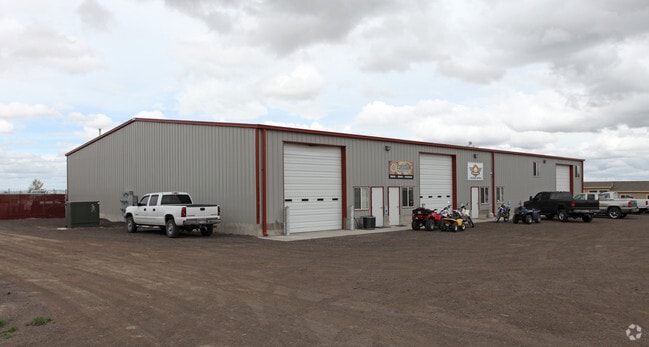

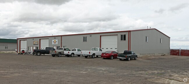
Property Detail
21338 E Highway 30 N
Twin Falls, ID
FILER CURRY CROSSING COMMERCIAL DEVELOPMENT AMENDED LOT 7 (11-10-16 SW)
RPOF2410000070A
TWIN FALLS
Autorepair
Idaho
B and X Area of moderate flood hazard, usually the area between the limits of the 100-year and 500-year floods.
7
2025
3.03 AC
2025
Idaho South Area
000500
Other Market Areas
10,880 SF
NEARBY LISTINGS FOR SALE OR LEASE
-
-
View all Filer listings for sale on LoopNet.com
DEMOGRAPHICS near 21338 E Highway 30 N
1 mile
3 mile
5 mile
2025 Total Population
530
9,949
51,231
2030 Population
557
10,543
54,177
Pop Growth 2025-2030
+ 5.09%
+ 5.97%
+ 5.75%
Average Age
41
39
38
2025 Total Households
185
3,525
19,036
HH Growth 2025-2030
+ 4.86%
+ 5.96%
+ 5.83%
Median Household Inc
$74,999
$68,498
$63,705
Avg Household Size
2.80
2.70
2.60
2025 Avg HH Vehicles
3.00
2.00
2.00
Median Home Value
$407,500
$366,488
$307,231
Median Year Built
1993
1990
1982
Nearby Places
Map Layers
Map Styles
 Street
 Aerial
Layers
 Traffic
 Biking
Places
Listings with unknown addresses are not visible on the map
- Restaurants
- Banks
- Shops
- Fitness
- Groceries
Nearby Properties
Address
Land Use
TOTAL SIZE
Lot Size
Zoning
Address
Land Use
TOTAL SIZE
Lot Size
Zoning
24,284 SF
3.68 AC
C-1
Address
Land Use
TOTAL SIZE
Lot Size
Zoning
5,234 SF
5 AC
R-6
Address
Land Use
TOTAL SIZE
Lot Size
Zoning
2,625 SF
5.08 AC
R-6
Address
Land Use
TOTAL SIZE
Lot Size
Zoning
41,489 SF
2.77 AC
C-1
Address
Land Use
TOTAL SIZE
Lot Size
Zoning
24,284 SF
1.47 AC
C-1
Address
Land Use
TOTAL SIZE
Lot Size
Zoning
8,120 SF
2.31 AC
R-4
Address
Land Use
TOTAL SIZE
Lot Size
Zoning
48,300 SF
7.15 AC
Address
Land Use
TOTAL SIZE
Lot Size
Zoning
71,579 SF
5.71 AC
C-1
Address
Land Use
TOTAL SIZE
Lot Size
Zoning
22,530 SF
3.34 AC
Address
Land Use
TOTAL SIZE
Lot Size
Zoning
40,687 SF
1.76 AC
R-6
Address
Land Use
TOTAL SIZE
Lot Size
Zoning
52,480 SF
1.48 AC
C-1
Address
Land Use
TOTAL SIZE
Lot Size
Zoning
12,410 SF
1.43 AC
C-1
Address
Land Use
TOTAL SIZE
Lot Size
Zoning
7,161 SF
3.34 AC
SUI
Address
Land Use
TOTAL SIZE
Lot Size
Zoning
14,800 SF
17 AC
M-2
Address
Land Use
TOTAL SIZE
Lot Size
Zoning
6,400 SF
7.09 AC
Address
Land Use
TOTAL SIZE
Lot Size
Zoning
5,894 SF
1.49 AC
Address
Land Use
TOTAL SIZE
Lot Size
Zoning
2,190 SF
29.64 AC
Address
Land Use
TOTAL SIZE
Lot Size
Zoning
7,870 SF
2.79 AC
C-1
Address
Land Use
TOTAL SIZE
Lot Size
Zoning
1,152 SF
66.89 AC
M-2
Address
Land Use
TOTAL SIZE
Lot Size
Zoning
28,208 SF
1.94 AC
R-6
Address
Land Use
TOTAL SIZE
Lot Size
Zoning
2.81 AC
Address
Land Use
TOTAL SIZE
Lot Size
Zoning
5,035 SF
1.01 AC
SUI
Address
Land Use
TOTAL SIZE
Lot Size
Zoning
5,743 SF
1.20 AC
Address
Land Use
TOTAL SIZE
Lot Size
Zoning
4,883 SF
1.02 AC
SUI
Address
Land Use
TOTAL SIZE
Lot Size
Zoning
24,207 SF
1.92 AC
R-6
Address
Land Use
TOTAL SIZE
Lot Size
Zoning
10,500 SF
3.03 AC
Address
Land Use
TOTAL SIZE
Lot Size
Zoning
155.77 AC
Address
Land Use
TOTAL SIZE
Lot Size
Zoning
3,900 SF
5.45 AC
The World's #1 Commercial Real Estate Marketplace
Connect with us
© 2026 CoStar Group
The information above has been obtained from sources believed reliable. While we do not doubt its accuracy we have not verified it and make no guarantee, warranty or representation about it. It is your responsibility to independently confirm its accuracy and completeness. Any projections, opinions, assumptions, or estimates used are for example only and do not represent the current or future performance of the property. The value of this transaction to you depends on tax and other factors which should be evaluated by your tax, financial, and legal advisors. You and your advisors should conduct a careful, independent investigation of the property to determine to your satisfaction the suitability of the property for your needs.