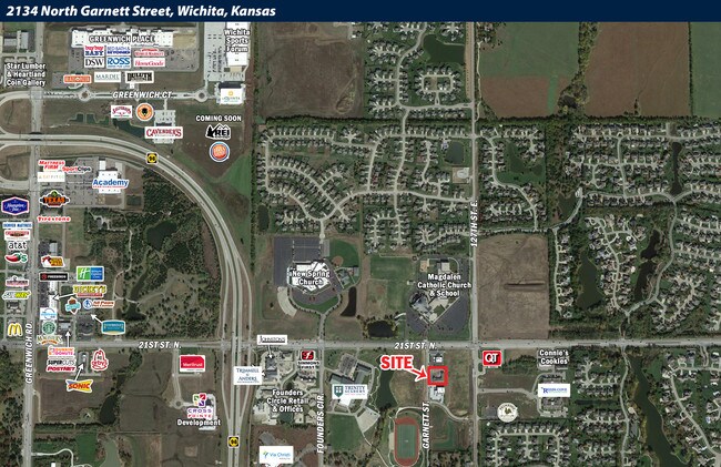
Property Record
2134 N Garnett St, Wichita, KS 67206


Current Lease Availabilities
NEARBY LISTINGS FOR SALE OR LEASE
Property Detail
2134 N Garnett St
Wichita, KS
Summit Crossing Add
112-10-0-11-02-003.00
LOT 6 BLOCK 1 SUMMIT CROSSING ADD
Stripcommercialcenter
Sedgwick
X
Kansas
20173C0377G
6
2024
0.81 AC
2025
Andover/East
010115
Wichita
8,576 SF
DEMOGRAPHICS near 2134 N Garnett St
1 Mile
3 Mile
5 Mile
2024 Total Population
4,717
29,124
105,012
2029 Population
4,774
29,770
106,823
Pop Growth 2024-2029
+ 1.21%
+ 2.22%
+ 1.72%
Average Age
38
40
39
2024 Total Households
1,508
10,774
41,675
HH Growth 2024-2029
+ 1.13%
+ 2.18%
+ 1.63%
Median Household Inc
$147,208
$110,349
$80,389
Avg Household Size
3.00
2.60
2.40
2024 Avg HH Vehicles
2.00
2.00
2.00
Median Home Value
$419,822
$339,903
$251,523
Median Year Built
2006
2000
1988
Nearby Places
Map Layers
Map Styles
 Street
 Aerial
- Restaurants
- Banks
- Shops
- Fitness
- Groceries
PUBLIC TRANSPORTATION
AIRPORT
Wichita Dwight D Eisenhower Ntl
DRIVE
WALK
Distance
Wichita Dwight D Eisenhower Ntl
26 min
18.5 mi
Freight Ports
Tulsa Port Of Catoosa
DRIVE
WALK
Distance
Tulsa Port Of Catoosa
212 min
200.1 mi
Nearby Properties
Address
Land Use
TOTAL SIZE
Lot Size
Zoning
Address
Land Use
TOTAL SIZE
Lot Size
Zoning
366,272 SF
332.54 AC
LI
Address
Land Use
TOTAL SIZE
Lot Size
Zoning
32.40 AC
Address
Land Use
TOTAL SIZE
Lot Size
Zoning
138,233 SF
23.01 AC
SF-5
Address
Land Use
TOTAL SIZE
Lot Size
Zoning
136,627 SF
27.46 AC
SF-5
Address
Land Use
TOTAL SIZE
Lot Size
Zoning
88,652 SF
21.92 AC
SF-5
Address
Land Use
TOTAL SIZE
Lot Size
Zoning
146,863 SF
14.24 AC
SF-5
Address
Land Use
TOTAL SIZE
Lot Size
Zoning
99,325 SF
17.83 AC
SF-5
Address
Land Use
TOTAL SIZE
Lot Size
Zoning
74,265 SF
15.01 AC
LC
Address
Land Use
TOTAL SIZE
Lot Size
Zoning
121,541 SF
47.63 AC
LI
Address
Land Use
TOTAL SIZE
Lot Size
Zoning
71,058 SF
17.47 AC
SF-5
Address
Land Use
TOTAL SIZE
Lot Size
Zoning
19.70 AC
Address
Land Use
TOTAL SIZE
Lot Size
Zoning
87,388 SF
19.72 AC
SF-5
Address
Land Use
TOTAL SIZE
Lot Size
Zoning
60,868 SF
4.17 AC
LI
Address
Land Use
TOTAL SIZE
Lot Size
Zoning
37,934 SF
24.82 AC
SF-5
Address
Land Use
TOTAL SIZE
Lot Size
Zoning
47,631 SF
13.66 AC
SF-5
Address
Land Use
TOTAL SIZE
Lot Size
Zoning
71,556 SF
19.67 AC
MF-18,MF-2
Address
Land Use
TOTAL SIZE
Lot Size
Zoning
43,148 SF
7.84 AC
SF-5
Address
Land Use
TOTAL SIZE
Lot Size
Zoning
86,031 SF
13.90 AC
SF-5
Address
Land Use
TOTAL SIZE
Lot Size
Zoning
46,816 SF
14.69 AC
SF-5
Address
Land Use
TOTAL SIZE
Lot Size
Zoning
81,791 SF
14.81 AC
SF-5
Address
Land Use
TOTAL SIZE
Lot Size
Zoning
38,149 SF
17.12 AC
MF-18,MF-2
Address
Land Use
TOTAL SIZE
Lot Size
Zoning
14,582 SF
5.30 AC
Address
Land Use
TOTAL SIZE
Lot Size
Zoning
38,759 SF
14.86 AC
SF-5
Address
Land Use
TOTAL SIZE
Lot Size
Zoning
19,396 SF
54.52 AC
LC,SF-5
Address
Land Use
TOTAL SIZE
Lot Size
Zoning
34,006 SF
8.01 AC
SF-5
Address
Land Use
TOTAL SIZE
Lot Size
Zoning
32,561 SF
18.04 AC
SF-5
Address
Land Use
TOTAL SIZE
Lot Size
Zoning
237,546 SF
34.16 AC
MF-18
Address
Land Use
TOTAL SIZE
Lot Size
Zoning
94,849 SF
11.54 AC
MF-18
Address
Land Use
TOTAL SIZE
Lot Size
Zoning
71,829 SF
4.41 AC
LI
Address
Land Use
TOTAL SIZE
Lot Size
Zoning
83,625 SF
11 AC
The World's #1 Commercial Real Estate Marketplace
Connect with us
© 2026 CoStar Group
The information above has been obtained from sources believed reliable. While we do not doubt its accuracy we have not verified it and make no guarantee, warranty or representation about it. It is your responsibility to independently confirm its accuracy and completeness. Any projections, opinions, assumptions, or estimates used are for example only and do not represent the current or future performance of the property. The value of this transaction to you depends on tax and other factors which should be evaluated by your tax, financial, and legal advisors. You and your advisors should conduct a careful, independent investigation of the property to determine to your satisfaction the suitability of the property for your needs.