Property Record
2135 Frink St, Cayce, SC 29033


NEARBY LISTINGS FOR SALE OR LEASE
-
-
View all Cayce listings for sale on LoopNet.com
Property Detail
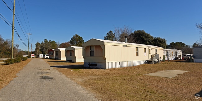
2135 Frink St
005759-07-021
NONE BROAD EDEN MOBILE HOME PARK
Mobilehomepark
Lexington
X
South Carolina
45063C0279J
6.45 AC
2025
West Columbia
2024
Columbia
020604
Columbia, SC
2,196 SF
DEMOGRAPHICS near 2135 Frink St
1 Mile
3 Mile
5 Mile
2024 Total Population
6,107
34,397
102,158
2029 Population
6,642
37,452
108,466
Pop Growth 2024-2029
+ 8.76%
+ 8.88%
+ 6.17%
Average Age
41
39
36
2024 Total Households
2,657
15,398
44,877
HH Growth 2024-2029
+ 8.88%
+ 9.25%
+ 6.42%
Median Household Inc
$55,164
$47,075
$49,578
Avg Household Size
2.20
2.10
2.00
2024 Avg HH Vehicles
2.00
2.00
2.00
Median Home Value
$124,180
$144,302
$169,480
Median Year Built
1968
1971
1976
Nearby Places
Map Layers
Map Styles
 Street
 Aerial
- Restaurants
- Banks
- Shops
- Fitness
- Groceries
PUBLIC TRANSPORTATION
COMMUTER RAIL
DRIVE
WALK
Distance
10 min
4.8 mi
AIRPORT
Columbia Metro
DRIVE
WALK
Distance
Columbia Metro
16 min
5.4 mi
SALE & LEASE HISTORY
LISTING DATE
SALE/LEASE

Sep 24, 2016
For Sale
Nearby Properties
Address
Land Use
TOTAL SIZE
Lot Size
Zoning
Address
Land Use
TOTAL SIZE
Lot Size
Zoning
490,633 SF
13.20 AC
RM-2
Address
Land Use
TOTAL SIZE
Lot Size
Zoning
121,560 SF
8.46 AC
RM-2
Address
Land Use
TOTAL SIZE
Lot Size
Zoning
196,800 SF
5.83 AC
HI
Address
Land Use
TOTAL SIZE
Lot Size
Zoning
12.50 AC
PD
Address
Land Use
TOTAL SIZE
Lot Size
Zoning
158,976 SF
11.28 AC
RM-2
Address
Land Use
TOTAL SIZE
Lot Size
Zoning
152,064 SF
9.58 AC
RM-2
Address
Land Use
TOTAL SIZE
Lot Size
Zoning
686,209 SF
1.73 AC
RM-2
Address
Land Use
TOTAL SIZE
Lot Size
Zoning
237 AC
HI
Address
Land Use
TOTAL SIZE
Lot Size
Zoning
56,245 SF
2.75 AC
RM-2
Address
Land Use
TOTAL SIZE
Lot Size
Zoning
14.88 AC
PD
Address
Land Use
TOTAL SIZE
Lot Size
Zoning
87,623 SF
2.12 AC
M-1
Address
Land Use
TOTAL SIZE
Lot Size
Zoning
8,800 SF
0.88 AC
MC
Address
Land Use
TOTAL SIZE
Lot Size
Zoning
95,854 SF
3.41 AC
M-1
Address
Land Use
TOTAL SIZE
Lot Size
Zoning
3,614 SF
1,444.32 AC
ID
Address
Land Use
TOTAL SIZE
Lot Size
Zoning
65,340 SF
2.72 AC
M-1
Address
Land Use
TOTAL SIZE
Lot Size
Zoning
24,480 SF
1.48 AC
MC
Address
Land Use
TOTAL SIZE
Lot Size
Zoning
67,626 SF
3.33 AC
M-1
Address
Land Use
TOTAL SIZE
Lot Size
Zoning
37,400 SF
11.42 AC
HI
Address
Land Use
TOTAL SIZE
Lot Size
Zoning
62,886 SF
10.15 AC
C3
Address
Land Use
TOTAL SIZE
Lot Size
Zoning
2,813 SF
3.97 AC
C2
Address
Land Use
TOTAL SIZE
Lot Size
Zoning
5,525 SF
0.80 AC
NAC
Address
Land Use
TOTAL SIZE
Lot Size
Zoning
20.65 AC
T/C
Address
Land Use
TOTAL SIZE
Lot Size
Zoning
42,500 SF
2.70 AC
M-1
Address
Land Use
TOTAL SIZE
Lot Size
Zoning
4,586 SF
19.15 AC
Address
Land Use
TOTAL SIZE
Lot Size
Zoning
21,018 SF
7.25 AC
R
Address
Land Use
TOTAL SIZE
Lot Size
Zoning
15,788 SF
1.52 AC
MC
Address
Land Use
TOTAL SIZE
Lot Size
Zoning
25,240 SF
9 AC
RG
Address
Land Use
TOTAL SIZE
Lot Size
Zoning
57,744 SF
1.93 AC
M-1
Address
Land Use
TOTAL SIZE
Lot Size
Zoning
87,936 SF
4.40 AC
HI
Address
Land Use
TOTAL SIZE
Lot Size
Zoning
1,218 SF
8.99 AC
RG
The World's #1 Commercial Real Estate Marketplace
Connect with us
© 2026 CoStar Group
The information above has been obtained from sources believed reliable. While we do not doubt its accuracy we have not verified it and make no guarantee, warranty or representation about it. It is your responsibility to independently confirm its accuracy and completeness. Any projections, opinions, assumptions, or estimates used are for example only and do not represent the current or future performance of the property. The value of this transaction to you depends on tax and other factors which should be evaluated by your tax, financial, and legal advisors. You and your advisors should conduct a careful, independent investigation of the property to determine to your satisfaction the suitability of the property for your needs.