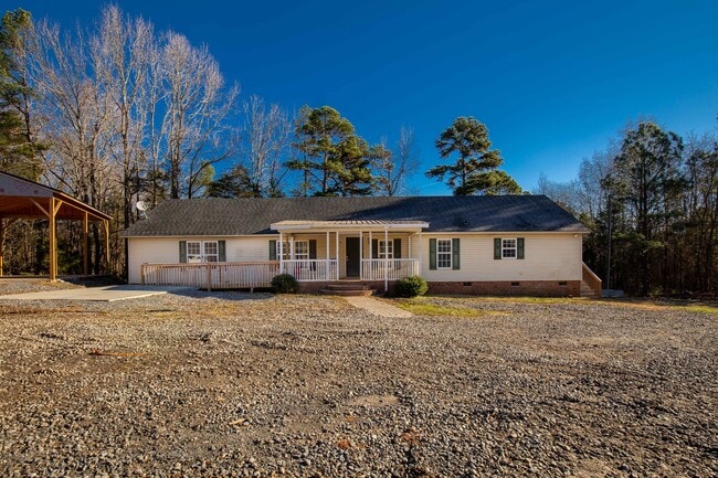
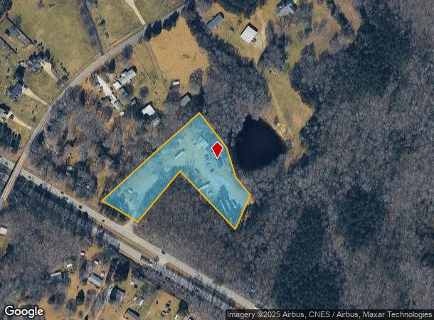
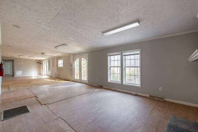
Property Record
2137 Anderson Rd S, Rock Hill, SC 29730
NEARBY LISTINGS FOR SALE OR LEASE
-
-
View all Rock Hill listings for sale on LoopNet.com
Property Detail
2137 Anderson Rd S
Charlotte-Concord-Gastonia, NC-SC
Mccall Meadows
6930000054
York
Residentialnec
South Carolina
X
1 AC
45057C0070D
York County
2,156 SF
Charlotte
DEMOGRAPHICS near 2137 Anderson Rd S
1 Mile
3 Mile
5 Mile
2024 Total Population
1,468
10,895
26,863
2029 Population
1,650
12,275
30,202
Pop Growth 2024-2029
+ 12.40%
+ 12.67%
+ 12.43%
Average Age
41
42
41
2024 Total Households
550
4,134
10,593
HH Growth 2024-2029
+ 12.91%
+ 13.06%
+ 12.79%
Median Household Inc
$67,983
$62,018
$58,179
Avg Household Size
2.60
2.60
2.50
2024 Avg HH Vehicles
2.00
2.00
2.00
Median Home Value
$226,451
$222,227
$229,617
Median Year Built
1995
1992
1995
Nearby Places
Map Layers
Map Styles
 Street
 Aerial
- Restaurants
- Banks
- Shops
- Fitness
- Groceries
PUBLIC TRANSPORTATION
AIRPORT
Charlotte/Douglas International
DRIVE
WALK
Distance
Charlotte/Douglas International
47 min
28.2 mi
Concord-Padgett Regional
DRIVE
WALK
Distance
Concord-Padgett Regional
65 min
45.2 mi
SALE & LEASE HISTORY
LISTING DATE
SALE/LEASE

Jan 17, 2022
For Sale
Nearby Properties
Address
Land Use
TOTAL SIZE
Lot Size
Zoning
Address
Land Use
TOTAL SIZE
Lot Size
Zoning
851,500 SF
72.70 AC
Address
Land Use
TOTAL SIZE
Lot Size
Zoning
460,800 SF
46.11 AC
Address
Land Use
TOTAL SIZE
Lot Size
Zoning
411,620 SF
30.34 AC
IG
Address
Land Use
TOTAL SIZE
Lot Size
Zoning
Address
Land Use
TOTAL SIZE
Lot Size
Zoning
103.02 AC
RDI
Address
Land Use
TOTAL SIZE
Lot Size
Zoning
193,960 SF
23.50 AC
Address
Land Use
TOTAL SIZE
Lot Size
Zoning
80.40 AC
RDI
Address
Land Use
TOTAL SIZE
Lot Size
Zoning
129,600 SF
22.06 AC
Address
Land Use
TOTAL SIZE
Lot Size
Zoning
10.45 AC
Address
Land Use
TOTAL SIZE
Lot Size
Zoning
122,040 SF
12.09 AC
Address
Land Use
TOTAL SIZE
Lot Size
Zoning
7,740 SF
5.34 AC
RDI
Address
Land Use
TOTAL SIZE
Lot Size
Zoning
3,426 SF
1.07 AC
RDI
Address
Land Use
TOTAL SIZE
Lot Size
Zoning
3,415 SF
1 AC
RDI
Address
Land Use
TOTAL SIZE
Lot Size
Zoning
4,587 SF
1 AC
RDI
Address
Land Use
TOTAL SIZE
Lot Size
Zoning
2,782 SF
1.42 AC
RDI
Address
Land Use
TOTAL SIZE
Lot Size
Zoning
2,677 SF
1 AC
RDI
Address
Land Use
TOTAL SIZE
Lot Size
Zoning
51.16 AC
RUD
Address
Land Use
TOTAL SIZE
Lot Size
Zoning
2,313 SF
1 AC
RCI
Address
Land Use
TOTAL SIZE
Lot Size
Zoning
2,495 SF
1 AC
PD
Address
Land Use
TOTAL SIZE
Lot Size
Zoning
2,042 SF
1 AC
RUD
Address
Land Use
TOTAL SIZE
Lot Size
Zoning
2,555 SF
1.66 AC
RUD
Address
Land Use
TOTAL SIZE
Lot Size
Zoning
2,269 SF
1 AC
PD
Address
Land Use
TOTAL SIZE
Lot Size
Zoning
1,883 SF
1 AC
RUDI
Address
Land Use
TOTAL SIZE
Lot Size
Zoning
1,812 SF
1 AC
RCI
Address
Land Use
TOTAL SIZE
Lot Size
Zoning
24.29 AC
RDI
Address
Land Use
TOTAL SIZE
Lot Size
Zoning
27.89 AC
RDI
Address
Land Use
TOTAL SIZE
Lot Size
Zoning
2,346 SF
2.80 AC
RC-I
Address
Land Use
TOTAL SIZE
Lot Size
Zoning
2,112 SF
3.34 AC
Address
Land Use
TOTAL SIZE
Lot Size
Zoning
2,547 SF
3 AC
RCI
Address
Land Use
TOTAL SIZE
Lot Size
Zoning
1,950 SF
1 AC
RDI
The World's #1 Commercial Real Estate Marketplace
Connect with us
© 2025 CoStar Group
The information above has been obtained from sources believed reliable. While we do not doubt its accuracy we have not verified it and make no guarantee, warranty or representation about it. It is your responsibility to independently confirm its accuracy and completeness. Any projections, opinions, assumptions, or estimates used are for example only and do not represent the current or future performance of the property. The value of this transaction to you depends on tax and other factors which should be evaluated by your tax, financial, and legal advisors. You and your advisors should conduct a careful, independent investigation of the property to determine to your satisfaction the suitability of the property for your needs.