Property Record
21370 W Mcnichols Rd, Detroit, MI 48219
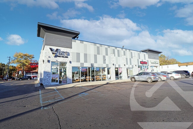
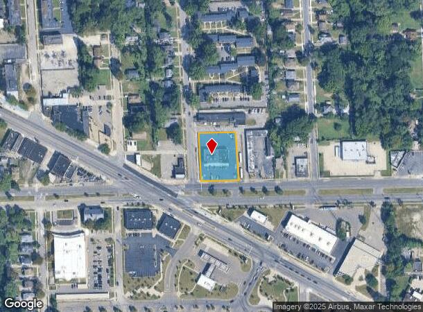
This Property Is For Sale
Current Lease Availabilities
NEARBY LISTINGS FOR SALE OR LEASE
Property Detail
21370 W Mcnichols Rd
22-013583
Serps Redford
Financialbuilding
N W MC NICHOLS 48 THRU 50 W 19.61 FT ON S LINE BG W 19.40 FT ON N LINE OF 51 S 80 FT OF W 155 FT OF 47 & 46 SERPS REDFORD SUB L40 P73 PLATS, W C R 22/400 155 X 200
X
Wayne
26163C0067E
Michigan
2025
0.71 AC
2025
Detroit W of Woodward
541200
Detroit
5,751 SF
Detroit-Warren-Dearborn, MI
DEMOGRAPHICS near 21370 W Mcnichols Rd
1 Mile
3 Mile
5 Mile
2024 Total Population
15,648
127,857
335,654
2029 Population
15,488
124,666
328,523
Pop Growth 2024-2029
(1.02%)
(2.50%)
(2.12%)
Average Age
38
39
39
2024 Total Households
6,102
51,466
134,100
HH Growth 2024-2029
(1.23%)
(2.61%)
(2.20%)
Median Household Inc
$37,226
$42,399
$46,608
Avg Household Size
2.50
2.40
2.40
2024 Avg HH Vehicles
1.00
1.00
1.00
Median Home Value
$71,954
$93,800
$114,388
Median Year Built
1950
1952
1954
Nearby Places
Map Layers
Map Styles
 Street
 Aerial
- Restaurants
- Banks
- Shops
- Fitness
- Groceries
PUBLIC TRANSPORTATION
COMMUTER RAIL
Dearborn (Wolverine - Amtrak)
DRIVE
WALK
Distance
Dearborn (Wolverine - Amtrak)
17 min
9.5 mi
AIRPORT
Detroit Metro Wayne County
DRIVE
WALK
Distance
Detroit Metro Wayne County
36 min
22.2 mi
Windsor International
DRIVE
WALK
Distance
Windsor International
43 min
24.5 mi
Freight Ports
Port of Toledo
DRIVE
WALK
Distance
Port of Toledo
85 min
64.2 mi
Nearby Properties
Address
Land Use
TOTAL SIZE
Lot Size
Zoning
Address
Land Use
TOTAL SIZE
Lot Size
Zoning
383,602 SF
36.60 AC
I-1
Address
Land Use
TOTAL SIZE
Lot Size
Zoning
1,211,148 SF
69.13 AC
M4
Address
Land Use
TOTAL SIZE
Lot Size
Zoning
85.45 AC
Address
Land Use
TOTAL SIZE
Lot Size
Zoning
397,200 SF
14.07 AC
RMU
Address
Land Use
TOTAL SIZE
Lot Size
Zoning
202,736 SF
20 AC
PD
Address
Land Use
TOTAL SIZE
Lot Size
Zoning
143,700 SF
3.27 AC
PD
Address
Land Use
TOTAL SIZE
Lot Size
Zoning
835,383 SF
36.85 AC
Address
Land Use
TOTAL SIZE
Lot Size
Zoning
300,936 SF
18.40 AC
M4
Address
Land Use
TOTAL SIZE
Lot Size
Zoning
158,092 SF
11.75 AC
B-3
Address
Land Use
TOTAL SIZE
Lot Size
Zoning
158,354 SF
43.70 AC
M4
Address
Land Use
TOTAL SIZE
Lot Size
Zoning
163,661 SF
8.92 AC
PD
Address
Land Use
TOTAL SIZE
Lot Size
Zoning
143,941 SF
11.66 AC
PD
Address
Land Use
TOTAL SIZE
Lot Size
Zoning
167,562 SF
9.25 AC
R5
Address
Land Use
TOTAL SIZE
Lot Size
Zoning
16.05 AC
I-1
Address
Land Use
TOTAL SIZE
Lot Size
Zoning
129,975 SF
6.89 AC
R5
Address
Land Use
TOTAL SIZE
Lot Size
Zoning
104,567 SF
2.14 AC
PD
Address
Land Use
TOTAL SIZE
Lot Size
Zoning
104 SF
8.93 AC
RM
Address
Land Use
TOTAL SIZE
Lot Size
Zoning
18.17 AC
I-L
Address
Land Use
TOTAL SIZE
Lot Size
Zoning
186.50 AC
IND
Address
Land Use
TOTAL SIZE
Lot Size
Zoning
137,658 SF
18.37 AC
I-L
Address
Land Use
TOTAL SIZE
Lot Size
Zoning
97,114 SF
2.10 AC
R1
Address
Land Use
TOTAL SIZE
Lot Size
Zoning
79,340 SF
3.20 AC
PD
Address
Land Use
TOTAL SIZE
Lot Size
Zoning
65,576 SF
7.84 AC
B3
Address
Land Use
TOTAL SIZE
Lot Size
Zoning
46,627 SF
5.26 AC
I-1
Address
Land Use
TOTAL SIZE
Lot Size
Zoning
110,242 SF
4.75 AC
Address
Land Use
TOTAL SIZE
Lot Size
Zoning
58,586 SF
5.62 AC
Address
Land Use
TOTAL SIZE
Lot Size
Zoning
15,952 SF
1.78 AC
I-L
Address
Land Use
TOTAL SIZE
Lot Size
Zoning
50,660 SF
8.41 AC
I-L
Address
Land Use
TOTAL SIZE
Lot Size
Zoning
362,981 SF
18.08 AC
M4
Address
Land Use
TOTAL SIZE
Lot Size
Zoning
7.52 AC
I-1
The World's #1 Commercial Real Estate Marketplace
Connect with us
© 2026 CoStar Group
The information above has been obtained from sources believed reliable. While we do not doubt its accuracy we have not verified it and make no guarantee, warranty or representation about it. It is your responsibility to independently confirm its accuracy and completeness. Any projections, opinions, assumptions, or estimates used are for example only and do not represent the current or future performance of the property. The value of this transaction to you depends on tax and other factors which should be evaluated by your tax, financial, and legal advisors. You and your advisors should conduct a careful, independent investigation of the property to determine to your satisfaction the suitability of the property for your needs.