Property Record
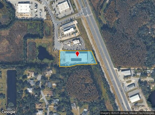
21370 Walmart Way, Lutz, FL 33548
NEARBY LISTINGS FOR SALE OR LEASE
Property Detail
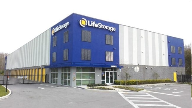
21370 Walmart Way
Tampa-St. Petersburg-Clearwater, FL
Outparcel To Shopping Center
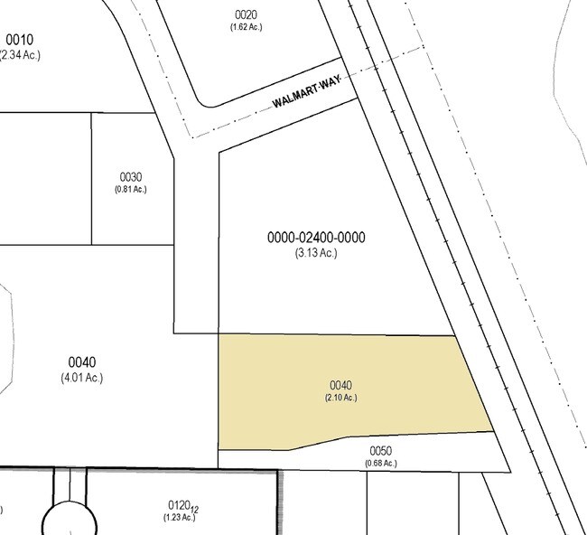
36-26-18-0000-02400-0040
PORTION OF THE SW1/4 OF SEC 36 DESC AS COM AT SW COR OF E1/4 OF NW1/4 OF SW1/4 OF SEC 36 TH S89DEG 2753E ALG SOUTH LINE OF NW1/4 OF SW1/4 OF SEC 223.03 FT TO POINT ON EAST LINE OF STORMWATER POND PARCEL DESC IN OR 7607 PG 1454 TH N00DEG 0445E 35.00 F
Warehouse
Pasco
AE
Florida
12101C0412F
4
2024
2.09 AC
2026
Pasco County
011103
Tampa/St Petersburg
98,701 SF
DEMOGRAPHICS near 21370 Walmart Way
1 Mile
3 Mile
5 Mile
2024 Total Population
4,826
41,746
110,914
2029 Population
5,779
48,691
129,099
Pop Growth 2024-2029
+ 19.75%
+ 16.64%
+ 16.40%
Average Age
42
41
40
2024 Total Households
1,967
15,561
40,398
HH Growth 2024-2029
+ 19.73%
+ 17.01%
+ 16.59%
Median Household Inc
$87,594
$108,217
$103,882
Avg Household Size
2.40
2.60
2.70
2024 Avg HH Vehicles
2.00
2.00
2.00
Median Home Value
$331,107
$380,792
$361,566
Median Year Built
1997
2000
2001
Nearby Places
Map Layers
Map Styles
 Street
 Aerial
- Restaurants
- Banks
- Shops
- Fitness
- Groceries
PUBLIC TRANSPORTATION
AIRPORT
Tampa International
DRIVE
WALK
Distance
Tampa International
33 min
22.1 mi
St Pete-Clearwater International
DRIVE
WALK
Distance
St Pete-Clearwater International
47 min
33.0 mi
Freight Ports
Port of Tampa Bay
DRIVE
WALK
Distance
Port of Tampa Bay
33 min
19.4 mi
Nearby Properties
Address
Land Use
TOTAL SIZE
Lot Size
Zoning
Address
Land Use
TOTAL SIZE
Lot Size
Zoning
366,691 SF
51.90 AC
MPUD
Address
Land Use
TOTAL SIZE
Lot Size
Zoning
291,175 SF
19.43 AC
MPUD
Address
Land Use
TOTAL SIZE
Lot Size
Zoning
285,532 SF
57.73 AC
MF1
Address
Land Use
TOTAL SIZE
Lot Size
Zoning
268,887 SF
31.52 AC
MF1
Address
Land Use
TOTAL SIZE
Lot Size
Zoning
138,949 SF
11.74 AC
MPUD
Address
Land Use
TOTAL SIZE
Lot Size
Zoning
2,850 SF
68.38 AC
PD
Address
Land Use
TOTAL SIZE
Lot Size
Zoning
92,467 SF
26.90 AC
MPUD
Address
Land Use
TOTAL SIZE
Lot Size
Zoning
89,269 SF
9.42 AC
C2
Address
Land Use
TOTAL SIZE
Lot Size
Zoning
62,050 SF
11.17 AC
PD
Address
Land Use
TOTAL SIZE
Lot Size
Zoning
85,151 SF
23.18 AC
C2
Address
Land Use
TOTAL SIZE
Lot Size
Zoning
102,882 SF
42.29 AC
MPUD
Address
Land Use
TOTAL SIZE
Lot Size
Zoning
74,366 SF
22.46 AC
PD
Address
Land Use
TOTAL SIZE
Lot Size
Zoning
88,803 SF
6.46 AC
C2
Address
Land Use
TOTAL SIZE
Lot Size
Zoning
63,500 SF
32.29 AC
PD
Address
Land Use
TOTAL SIZE
Lot Size
Zoning
129,324 SF
4.95 AC
C2
Address
Land Use
TOTAL SIZE
Lot Size
Zoning
109,726 SF
4.54 AC
C2
Address
Land Use
TOTAL SIZE
Lot Size
Zoning
195,182 SF
22.91 AC
MPUD
Address
Land Use
TOTAL SIZE
Lot Size
Zoning
133,367 SF
11.98 AC
CG
Address
Land Use
TOTAL SIZE
Lot Size
Zoning
91,241 SF
8.38 AC
ASC-1
Address
Land Use
TOTAL SIZE
Lot Size
Zoning
65,365 SF
8.68 AC
PD
Address
Land Use
TOTAL SIZE
Lot Size
Zoning
129,365 SF
5 AC
C2
Address
Land Use
TOTAL SIZE
Lot Size
Zoning
104,550 SF
14.03 AC
C2
Address
Land Use
TOTAL SIZE
Lot Size
Zoning
120,547 SF
40.64 AC
C2
Address
Land Use
TOTAL SIZE
Lot Size
Zoning
96,779 SF
7.10 AC
MPUD
Address
Land Use
TOTAL SIZE
Lot Size
Zoning
97,656 SF
1.87 AC
C2
Address
Land Use
TOTAL SIZE
Lot Size
Zoning
85,626 SF
14.47 AC
PD
Address
Land Use
TOTAL SIZE
Lot Size
Zoning
52,275 SF
4.98 AC
MPUD
Address
Land Use
TOTAL SIZE
Lot Size
Zoning
95,769 SF
12.96 AC
RSC-6
Address
Land Use
TOTAL SIZE
Lot Size
Zoning
69,956 SF
3.87 AC
PD
The World's #1 Commercial Real Estate Marketplace
Connect with us
© 2026 CoStar Group
The information above has been obtained from sources believed reliable. While we do not doubt its accuracy we have not verified it and make no guarantee, warranty or representation about it. It is your responsibility to independently confirm its accuracy and completeness. Any projections, opinions, assumptions, or estimates used are for example only and do not represent the current or future performance of the property. The value of this transaction to you depends on tax and other factors which should be evaluated by your tax, financial, and legal advisors. You and your advisors should conduct a careful, independent investigation of the property to determine to your satisfaction the suitability of the property for your needs.