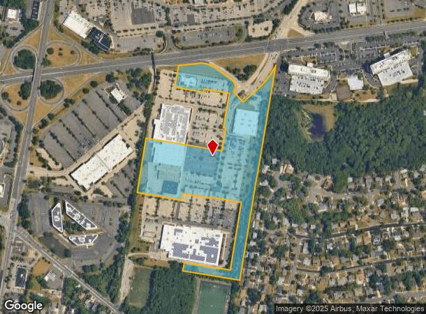
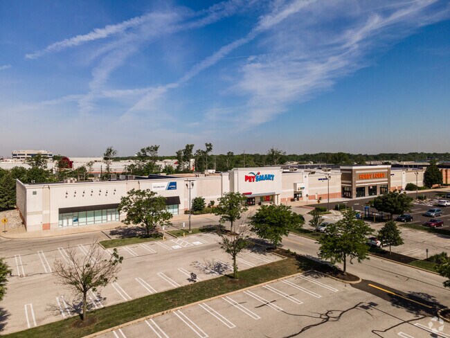
Property Record
2139 Route 38, Cherry Hill, NJ 08002


NEARBY LISTINGS FOR SALE OR LEASE
Property Detail
2139 Route 38
Philadelphia-Camden-Wilmington, PA-NJ-DE-MD
INCL BLK 285-25 LOTS 4-02 4-04 6 & 8
09-00285-25-00004-02
Camden
Commercialnec
New Jersey
X
4.2
34007C0042E
18.99 AC
2024
North Camden County
2025
Philadelphia
603301
DEMOGRAPHICS near 2139 Route 38
1 Mile
3 Mile
5 Mile
2024 Total Population
12,709
128,745
302,703
2029 Population
13,003
128,934
304,508
Pop Growth 2024-2029
+ 2.31%
+ 0.15%
+ 0.60%
Average Age
41
40
40
2024 Total Households
5,014
50,672
115,517
HH Growth 2024-2029
+ 2.53%
+ 0.20%
+ 0.62%
Median Household Inc
$107,327
$88,580
$81,703
Avg Household Size
2.40
2.50
2.50
2024 Avg HH Vehicles
2.00
2.00
2.00
Median Home Value
$283,068
$263,007
$270,103
Median Year Built
1969
1959
1958
Nearby Places
Map Layers
Map Styles
 Street
 Aerial
- Restaurants
- Banks
- Shops
- Fitness
- Groceries
PUBLIC TRANSPORTATION
COMMUTER RAIL
Cherry Hill (Atlantic City Line - NJ Transit Commuter Rail (NJ Transit))
DRIVE
WALK
Distance
Cherry Hill (Atlantic City Line - NJ Transit Commuter Rail (NJ Transit))
7 min
3.4 mi
Pennsauken Transit Center (Atlantic City Rail Line - NJ TRANSIT RAIL)
DRIVE
WALK
Distance
Pennsauken Transit Center (Atlantic City Rail Line - NJ TRANSIT RAIL)
9 min
4.5 mi
AIRPORT
Philadelphia International
DRIVE
WALK
Distance
Philadelphia International
29 min
16.5 mi
Trenton Mercer
DRIVE
WALK
Distance
Trenton Mercer
51 min
35.0 mi
Freight Ports
Port of Philadelphia
DRIVE
WALK
Distance
Port of Philadelphia
15 min
8.8 mi
SALE & LEASE HISTORY
LISTING DATE
SALE/LEASE

Sep 25, 2016
For Lease
Nearby Properties
Address
Land Use
TOTAL SIZE
Lot Size
Zoning
Address
Land Use
TOTAL SIZE
Lot Size
Zoning
66.02 AC
Address
Land Use
TOTAL SIZE
Lot Size
Zoning
Address
Land Use
TOTAL SIZE
Lot Size
Zoning
90.41 AC
Address
Land Use
TOTAL SIZE
Lot Size
Zoning
20.13 AC
Address
Land Use
TOTAL SIZE
Lot Size
Zoning
49.16 AC
Address
Land Use
TOTAL SIZE
Lot Size
Zoning
23.82 AC
Address
Land Use
TOTAL SIZE
Lot Size
Zoning
10,292 SF
21.30 AC
Address
Land Use
TOTAL SIZE
Lot Size
Zoning
1 SF
42.23 AC
Address
Land Use
TOTAL SIZE
Lot Size
Zoning
37.60 AC
Address
Land Use
TOTAL SIZE
Lot Size
Zoning
Address
Land Use
TOTAL SIZE
Lot Size
Zoning
12.80 AC
R20
Address
Land Use
TOTAL SIZE
Lot Size
Zoning
1.48 AC
PCR
Address
Land Use
TOTAL SIZE
Lot Size
Zoning
17.62 AC
Address
Land Use
TOTAL SIZE
Lot Size
Zoning
14.11 AC
RG
Address
Land Use
TOTAL SIZE
Lot Size
Zoning
12.68 AC
RG
Address
Land Use
TOTAL SIZE
Lot Size
Zoning
16,796 SF
20.22 AC
RH
Address
Land Use
TOTAL SIZE
Lot Size
Zoning
Address
Land Use
TOTAL SIZE
Lot Size
Zoning
43.20 AC
Address
Land Use
TOTAL SIZE
Lot Size
Zoning
27.83 AC
Address
Land Use
TOTAL SIZE
Lot Size
Zoning
5.24 AC
Address
Land Use
TOTAL SIZE
Lot Size
Zoning
Address
Land Use
TOTAL SIZE
Lot Size
Zoning
6.30 AC
Address
Land Use
TOTAL SIZE
Lot Size
Zoning
32.46 AC
Address
Land Use
TOTAL SIZE
Lot Size
Zoning
5.35 AC
Address
Land Use
TOTAL SIZE
Lot Size
Zoning
Address
Land Use
TOTAL SIZE
Lot Size
Zoning
28.96 AC
Address
Land Use
TOTAL SIZE
Lot Size
Zoning
4.93 AC
Address
Land Use
TOTAL SIZE
Lot Size
Zoning
8.85 AC
Address
Land Use
TOTAL SIZE
Lot Size
Zoning
22.45 AC
MD
Address
Land Use
TOTAL SIZE
Lot Size
Zoning
The World's #1 Commercial Real Estate Marketplace
Connect with us
© 2025 CoStar Group
The information above has been obtained from sources believed reliable. While we do not doubt its accuracy we have not verified it and make no guarantee, warranty or representation about it. It is your responsibility to independently confirm its accuracy and completeness. Any projections, opinions, assumptions, or estimates used are for example only and do not represent the current or future performance of the property. The value of this transaction to you depends on tax and other factors which should be evaluated by your tax, financial, and legal advisors. You and your advisors should conduct a careful, independent investigation of the property to determine to your satisfaction the suitability of the property for your needs.