Property Record
214 Podraza Rd, New Waverly, TX 77358

Property Detail
214 Podraza Rd
10792
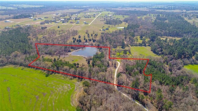
COLLARD L M (A-10), TRACT 43, ACRES 96.58
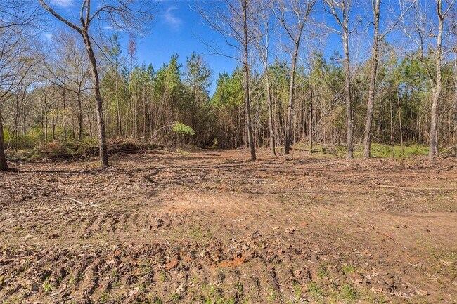
Privatepreserveopenspacevacantlandforestlandconservation
WALKER
B and X Area of moderate flood hazard, usually the area between the limits of the 100-year and 500-year floods.
Texas
2024
96.58 AC
2025
Texas East Area
790200
Other Market Areas
960 SF
Huntsville, TX
NEARBY LISTINGS FOR SALE OR LEASE
DEMOGRAPHICS near 214 Podraza Rd
1 mile
3 mile
5 mile
2025 Total Population
187
2,294
5,552
2030 Population
199
2,413
6,026
Pop Growth 2025-2030
+ 6.42%
+ 5.19%
+ 8.54%
Average Age
41
41
42
2025 Total Households
71
908
2,202
HH Growth 2025-2030
+ 7.04%
+ 5.40%
+ 8.86%
Median Household Inc
$58,888
$60,095
$66,894
Avg Household Size
2.60
2.50
2.50
2025 Avg HH Vehicles
2.00
2.00
2.00
Median Home Value
$173,076
$220,968
$257,908
Median Year Built
1988
1988
1992
Nearby Places
Map Layers
Map Styles
 Street
 Aerial
Transit
 Traffic
 Biking
Places
Listings with unknown addresses are not visible on the map
- Restaurants
- Banks
- Shops
- Fitness
- Groceries
SALE & LEASE HISTORY
LISTING DATE
SALE/LEASE

Jun 15, 2020
For Sale
Nearby Properties
Address
Land Use
TOTAL SIZE
Lot Size
Zoning
Address
Land Use
TOTAL SIZE
Lot Size
Zoning
4,196 SF
23.77 AC
Address
Land Use
TOTAL SIZE
Lot Size
Zoning
Address
Land Use
TOTAL SIZE
Lot Size
Zoning
Address
Land Use
TOTAL SIZE
Lot Size
Zoning
101,687 SF
149.34 AC
Address
Land Use
TOTAL SIZE
Lot Size
Zoning
170,275 SF
12.18 AC
Address
Land Use
TOTAL SIZE
Lot Size
Zoning
Address
Land Use
TOTAL SIZE
Lot Size
Zoning
46,968 SF
1.61 AC
Address
Land Use
TOTAL SIZE
Lot Size
Zoning
2,432 SF
5 AC
Address
Land Use
TOTAL SIZE
Lot Size
Zoning
54,999 SF
1.70 AC
Address
Land Use
TOTAL SIZE
Lot Size
Zoning
65,047 SF
2.40 AC
Address
Land Use
TOTAL SIZE
Lot Size
Zoning
Address
Land Use
TOTAL SIZE
Lot Size
Zoning
6,230 SF
5.98 AC
Address
Land Use
TOTAL SIZE
Lot Size
Zoning
51,412 SF
1.34 AC
Address
Land Use
TOTAL SIZE
Lot Size
Zoning
1,221 SF
2.06 AC
Address
Land Use
TOTAL SIZE
Lot Size
Zoning
71,638 SF
3.52 AC
Address
Land Use
TOTAL SIZE
Lot Size
Zoning
2.96 AC
Address
Land Use
TOTAL SIZE
Lot Size
Zoning
1,270 SF
7.83 AC
Address
Land Use
TOTAL SIZE
Lot Size
Zoning
6,284 SF
60.98 AC
Address
Land Use
TOTAL SIZE
Lot Size
Zoning
78.47 AC
Address
Land Use
TOTAL SIZE
Lot Size
Zoning
50 AC
Address
Land Use
TOTAL SIZE
Lot Size
Zoning
1.53 AC
Address
Land Use
TOTAL SIZE
Lot Size
Zoning
62,886 SF
4 AC
Address
Land Use
TOTAL SIZE
Lot Size
Zoning
1,350 SF
2.42 AC
Address
Land Use
TOTAL SIZE
Lot Size
Zoning
Address
Land Use
TOTAL SIZE
Lot Size
Zoning
5,575 SF
45.09 AC
Address
Land Use
TOTAL SIZE
Lot Size
Zoning
18,827 SF
4 AC
Address
Land Use
TOTAL SIZE
Lot Size
Zoning
5,838 SF
35.44 AC
Address
Land Use
TOTAL SIZE
Lot Size
Zoning
21,991 SF
1 AC
Address
Land Use
TOTAL SIZE
Lot Size
Zoning
875 SF
7.16 AC
Address
Land Use
TOTAL SIZE
Lot Size
Zoning
2,820 SF
20 AC
The World's #1 Commercial Real Estate Marketplace
Connect with us
© 2026 CoStar Group
The information above has been obtained from sources believed reliable. While we do not doubt its accuracy we have not verified it and make no guarantee, warranty or representation about it. It is your responsibility to independently confirm its accuracy and completeness. Any projections, opinions, assumptions, or estimates used are for example only and do not represent the current or future performance of the property. The value of this transaction to you depends on tax and other factors which should be evaluated by your tax, financial, and legal advisors. You and your advisors should conduct a careful, independent investigation of the property to determine to your satisfaction the suitability of the property for your needs.