Property Record
34 W Main Ave, Taylorsville, NC 28681
NEARBY LISTINGS FOR SALE OR LEASE
-
-
View all Taylorsville listings for lease on LoopNet.com
Property Detail
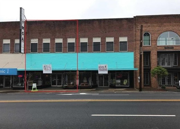
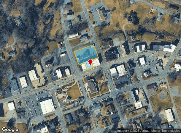
34 W Main Ave
0008137
Smitheys
Storebuilding
MAP 3759 SUBMAP 58 BLOCK 7050 (PIN) MAIN ST E-7D 1302
X
Alexander
3710375900J
North Carolina
2025
1 AC
2025
Alexander County
040400
Charlotte
12,800 SF
Hickory-Lenoir-Morganton, NC
DEMOGRAPHICS near 34 W Main Ave
1 Mile
3 Mile
5 Mile
2024 Total Population
2,859
8,250
15,571
2029 Population
2,937
8,461
15,909
Pop Growth 2024-2029
+ 2.73%
+ 2.56%
+ 2.17%
Average Age
43
42
42
2024 Total Households
1,195
3,290
6,017
HH Growth 2024-2029
+ 2.59%
+ 2.64%
+ 2.29%
Median Household Inc
$51,176
$50,182
$49,838
Avg Household Size
2.30
2.40
2.40
2024 Avg HH Vehicles
2.00
2.00
2.00
Median Home Value
$142,777
$145,432
$156,057
Median Year Built
1981
1981
1982
Nearby Places
- Restaurants
- Banks
- Shops
- Fitness
- Groceries
SALE & LEASE HISTORY
LISTING DATE
SALE/LEASE

Oct 05, 2022
For Lease
Mar 01, 2018
For Sale
Nearby Properties
Address
Land Use
TOTAL SIZE
Lot Size
Zoning
Address
Land Use
TOTAL SIZE
Lot Size
Zoning
420,350 SF
128 AC
HI
Address
Land Use
TOTAL SIZE
Lot Size
Zoning
35,340 SF
49.23 AC
R2
Address
Land Use
TOTAL SIZE
Lot Size
Zoning
63,339 SF
12.99 AC
B2
Address
Land Use
TOTAL SIZE
Lot Size
Zoning
107,088 SF
8.11 AC
B4
Address
Land Use
TOTAL SIZE
Lot Size
Zoning
403,694 SF
75.56 AC
RA20
Address
Land Use
TOTAL SIZE
Lot Size
Zoning
35,560 SF
1.17 AC
B2
Address
Land Use
TOTAL SIZE
Lot Size
Zoning
15,074 SF
10.83 AC
R2
Address
Land Use
TOTAL SIZE
Lot Size
Zoning
17,797 SF
2.98 AC
B2
Address
Land Use
TOTAL SIZE
Lot Size
Zoning
70,000 SF
25.61 AC
LI
Address
Land Use
TOTAL SIZE
Lot Size
Zoning
32,400 SF
25.22 AC
LI
Address
Land Use
TOTAL SIZE
Lot Size
Zoning
19,842 SF
4.06 AC
B4
Address
Land Use
TOTAL SIZE
Lot Size
Zoning
19,052 SF
8.23 AC
R2
Address
Land Use
TOTAL SIZE
Lot Size
Zoning
154,362 SF
21.29 AC
M2
Address
Land Use
TOTAL SIZE
Lot Size
Zoning
1,680 SF
3.59 AC
R2
Address
Land Use
TOTAL SIZE
Lot Size
Zoning
39,550 SF
5.03 AC
B2
Address
Land Use
TOTAL SIZE
Lot Size
Zoning
15,725 SF
2.51 AC
R2
Address
Land Use
TOTAL SIZE
Lot Size
Zoning
46,730 SF
5.39 AC
B2
Address
Land Use
TOTAL SIZE
Lot Size
Zoning
2,002 SF
7.42 AC
R2
Address
Land Use
TOTAL SIZE
Lot Size
Zoning
116,794 SF
10 AC
LI
Address
Land Use
TOTAL SIZE
Lot Size
Zoning
17,194 SF
3.15 AC
B2
Address
Land Use
TOTAL SIZE
Lot Size
Zoning
15,920 SF
2.97 AC
RA20
Address
Land Use
TOTAL SIZE
Lot Size
Zoning
9,009 SF
9.05 AC
RA20
Address
Land Use
TOTAL SIZE
Lot Size
Zoning
15,124 SF
3.19 AC
B2
Address
Land Use
TOTAL SIZE
Lot Size
Zoning
13,754 SF
3.36 AC
M2
Address
Land Use
TOTAL SIZE
Lot Size
Zoning
11,380 SF
1.07 AC
B1
Address
Land Use
TOTAL SIZE
Lot Size
Zoning
21,750 SF
3.45 AC
Address
Land Use
TOTAL SIZE
Lot Size
Zoning
97,442 SF
13.39 AC
RA20
Address
Land Use
TOTAL SIZE
Lot Size
Zoning
8,784 SF
5.58 AC
R2
Address
Land Use
TOTAL SIZE
Lot Size
Zoning
36,900 SF
6.51 AC
M2
Address
Land Use
TOTAL SIZE
Lot Size
Zoning
13,200 SF
2 AC
B2
The World's #1 Commercial Real Estate Marketplace
Connect with us
© 2025 CoStar Group
The information above has been obtained from sources believed reliable. While we do not doubt its accuracy we have not verified it and make no guarantee, warranty or representation about it. It is your responsibility to independently confirm its accuracy and completeness. Any projections, opinions, assumptions, or estimates used are for example only and do not represent the current or future performance of the property. The value of this transaction to you depends on tax and other factors which should be evaluated by your tax, financial, and legal advisors. You and your advisors should conduct a careful, independent investigation of the property to determine to your satisfaction the suitability of the property for your needs.