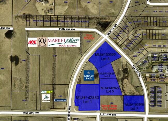
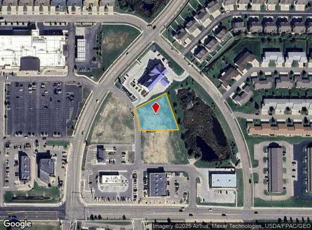
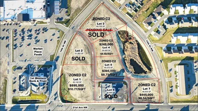
Property Record
2140 15Th St Nw, Minot, ND 58703
NEARBY LISTINGS FOR SALE OR LEASE
Property Detail
2140 15Th St Nw
Other Market Areas
Lakeside 21St
Minot, ND
SUB: MI10E14 LAKESIDE 21ST ADDITION LOT 4
MI-10E14-000-004-0
Ward
Commercialacreage
North Dakota
2024
4
2024
0.65 AC
010800
North Hill
DEMOGRAPHICS near 2140 15Th St Nw
1 Mile
3 Mile
5 Mile
2024 Total Population
9,093
32,020
50,566
2029 Population
8,974
31,532
49,811
Pop Growth 2024-2029
(1.31%)
(1.52%)
(1.49%)
Average Age
36
36
38
2024 Total Households
4,035
13,556
21,705
HH Growth 2024-2029
(1.41%)
(1.59%)
(1.54%)
Median Household Inc
$72,541
$70,654
$68,635
Avg Household Size
2.20
2.20
2.20
2024 Avg HH Vehicles
2.00
2.00
2.00
Median Home Value
$238,559
$233,350
$234,625
Median Year Built
1986
1976
1983
Nearby Places
Map Layers
Map Styles
 Street
 Aerial
- Restaurants
- Banks
- Shops
- Fitness
- Groceries
PUBLIC TRANSPORTATION
COMMUTER RAIL
Minot Amtrak Station (Empire Builder - Amtrak)
DRIVE
WALK
Distance
Minot Amtrak Station (Empire Builder - Amtrak)
7 min
2.9 mi
AIRPORT
Minot International
DRIVE
WALK
Distance
Minot International
8 min
2.3 mi
Freight Ports
Port Milwaukee
DRIVE
WALK
Distance
Port Milwaukee
950 min
874.3 mi
SALE & LEASE HISTORY
LISTING DATE
SALE/LEASE

Jun 27, 2017
For Sale
Jan 25, 2018
For Sale
Nearby Properties
Address
Land Use
TOTAL SIZE
Lot Size
Zoning
Address
Land Use
TOTAL SIZE
Lot Size
Zoning
121,307 SF
2.97 AC
Address
Land Use
TOTAL SIZE
Lot Size
Zoning
29,172 SF
9.19 AC
Address
Land Use
TOTAL SIZE
Lot Size
Zoning
41,710 SF
2.45 AC
Address
Land Use
TOTAL SIZE
Lot Size
Zoning
14,400 SF
4.46 AC
Address
Land Use
TOTAL SIZE
Lot Size
Zoning
46,496 SF
2.41 AC
Address
Land Use
TOTAL SIZE
Lot Size
Zoning
47,150 SF
6.43 AC
Address
Land Use
TOTAL SIZE
Lot Size
Zoning
30,000 SF
8.53 AC
Address
Land Use
TOTAL SIZE
Lot Size
Zoning
31,924 SF
2.82 AC
Address
Land Use
TOTAL SIZE
Lot Size
Zoning
9.49 AC
Address
Land Use
TOTAL SIZE
Lot Size
Zoning
6,120 SF
0.53 AC
Address
Land Use
TOTAL SIZE
Lot Size
Zoning
6,930 SF
0.51 AC
Address
Land Use
TOTAL SIZE
Lot Size
Zoning
15,000 SF
4.57 AC
Address
Land Use
TOTAL SIZE
Lot Size
Zoning
9,900 SF
1.39 AC
Address
Land Use
TOTAL SIZE
Lot Size
Zoning
5,400 SF
0.46 AC
Address
Land Use
TOTAL SIZE
Lot Size
Zoning
3,894 SF
0.62 AC
Address
Land Use
TOTAL SIZE
Lot Size
Zoning
4,244 SF
0.60 AC
Address
Land Use
TOTAL SIZE
Lot Size
Zoning
20,818 SF
1.80 AC
Address
Land Use
TOTAL SIZE
Lot Size
Zoning
13.84 AC
Address
Land Use
TOTAL SIZE
Lot Size
Zoning
3,767 SF
0.47 AC
Address
Land Use
TOTAL SIZE
Lot Size
Zoning
1,600 SF
2.01 AC
Address
Land Use
TOTAL SIZE
Lot Size
Zoning
12,400 SF
0.67 AC
Address
Land Use
TOTAL SIZE
Lot Size
Zoning
12.79 AC
Address
Land Use
TOTAL SIZE
Lot Size
Zoning
20,504 SF
0.24 AC
Address
Land Use
TOTAL SIZE
Lot Size
Zoning
10,800 SF
2 AC
Address
Land Use
TOTAL SIZE
Lot Size
Zoning
5,525 SF
0.63 AC
Address
Land Use
TOTAL SIZE
Lot Size
Zoning
1.51 AC
Address
Land Use
TOTAL SIZE
Lot Size
Zoning
6,000 SF
3.17 AC
The World's #1 Commercial Real Estate Marketplace
Connect with us
© 2026 CoStar Group
The information above has been obtained from sources believed reliable. While we do not doubt its accuracy we have not verified it and make no guarantee, warranty or representation about it. It is your responsibility to independently confirm its accuracy and completeness. Any projections, opinions, assumptions, or estimates used are for example only and do not represent the current or future performance of the property. The value of this transaction to you depends on tax and other factors which should be evaluated by your tax, financial, and legal advisors. You and your advisors should conduct a careful, independent investigation of the property to determine to your satisfaction the suitability of the property for your needs.