Property Record
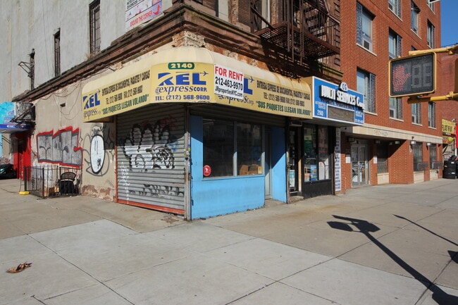
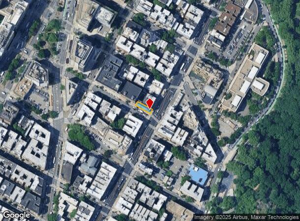
2140 Amsterdam Ave, New York, NY 10032
NEARBY LISTINGS FOR SALE OR LEASE
Property Detail
2140 Amsterdam Ave
2123-0069
Manhattan
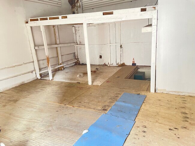
Storebuilding
New York
X
69
34003C0279H
0.06 AC
2024
Harlem/North Manhattan
2025
New York City
025100
New York-Jersey City-White Plains, NY-NJ
2,375 SF
DEMOGRAPHICS near 2140 Amsterdam Ave
1 Mile
3 Mile
5 Mile
2024 Total Population
177,420
1,191,647
2,257,107
2029 Population
165,121
1,116,670
2,104,436
Pop Growth 2024-2029
(6.93%)
(6.29%)
(6.76%)
Average Age
40
39
40
2024 Total Households
66,389
445,270
885,236
HH Growth 2024-2029
(7.25%)
(6.68%)
(7.22%)
Median Household Inc
$47,387
$43,349
$55,361
Avg Household Size
2.50
2.50
2.40
2024 Avg HH Vehicles
.00
.00
.00
Median Home Value
$592,075
$570,484
$695,070
Median Year Built
1947
1952
1951
Nearby Places
Map Layers
Map Styles
 Street
 Aerial
- Restaurants
- Banks
- Shops
- Fitness
- Groceries
PUBLIC TRANSPORTATION
TRANSIT/SUBWAY
Washington Heights-168 Street (A - New York MTA Subway (The Subway), C - New York MTA Subway (The Subway))
DRIVE
WALK
Distance
Washington Heights-168 Street (A - New York MTA Subway (The Subway), C - New York MTA Subway (The Subway))
0 min
4 min
0.2 mi
163 Street-Amsterdam Avenue (A - New York MTA Subway (The Subway), C - New York MTA Subway (The Subway))
DRIVE
WALK
Distance
163 Street-Amsterdam Avenue (A - New York MTA Subway (The Subway), C - New York MTA Subway (The Subway))
0 min
5 min
0.3 mi
155 Street (A,C Line) (A - New York MTA Subway (The Subway), C - New York MTA Subway (The Subway))
DRIVE
WALK
Distance
155 Street (A,C Line) (A - New York MTA Subway (The Subway), C - New York MTA Subway (The Subway))
1 min
11 min
0.6 mi
157 Street (1 - New York MTA Subway (The Subway))
DRIVE
WALK
Distance
157 Street (1 - New York MTA Subway (The Subway))
1 min
12 min
0.6 mi
175 Street (A - New York MTA Subway (The Subway))
DRIVE
WALK
Distance
175 Street (A - New York MTA Subway (The Subway))
2 min
12 min
0.6 mi
COMMUTER RAIL
Highbridge Yard (Hudson - Metro-North Railroad)
DRIVE
WALK
Distance
Highbridge Yard (Hudson - Metro-North Railroad)
6 min
2.1 mi
Yankees-E 153Rd Street Station (Hudson Line - Metro-North Commuter Railroad Company (Metro-North))
DRIVE
WALK
Distance
Yankees-E 153Rd Street Station (Hudson Line - Metro-North Commuter Railroad Company (Metro-North))
7 min
3.1 mi
AIRPORT
LaGuardia
DRIVE
WALK
Distance
LaGuardia
18 min
8.7 mi
Newark Liberty International
DRIVE
WALK
Distance
Newark Liberty International
25 min
21.0 mi
John F Kennedy International
DRIVE
WALK
Distance
John F Kennedy International
31 min
21.1 mi
Freight Ports
NY - Red Hook Container Terminal
DRIVE
WALK
Distance
NY - Red Hook Container Terminal
31 min
15.4 mi
SALE & LEASE HISTORY
LISTING DATE
SALE/LEASE

Sep 28, 2023
For Lease
Oct 16, 2024
For Lease
Feb 21, 2023
For Lease
Feb 03, 2022
For Lease
Apr 04, 2024
For Lease
Nearby Properties
Address
Land Use
TOTAL SIZE
Lot Size
Zoning
Address
Land Use
TOTAL SIZE
Lot Size
Zoning
3,693,539 SF
8.37 AC
R8
Address
Land Use
TOTAL SIZE
Lot Size
Zoning
400,160 SF
10.96 AC
R7-2
Address
Land Use
TOTAL SIZE
Lot Size
Zoning
1,299,700 SF
29.82 AC
R6
Address
Land Use
TOTAL SIZE
Lot Size
Zoning
1,743,584 SF
77.87 AC
R6
Address
Land Use
TOTAL SIZE
Lot Size
Zoning
26.93 AC
R8
Address
Land Use
TOTAL SIZE
Lot Size
Zoning
1,368,870 SF
16.86 AC
R8
Address
Land Use
TOTAL SIZE
Lot Size
Zoning
2,278,432 SF
5.99 AC
R7-2
Address
Land Use
TOTAL SIZE
Lot Size
Zoning
24.08 AC
B2-A
Address
Land Use
TOTAL SIZE
Lot Size
Zoning
4.87 AC
R11
Address
Land Use
TOTAL SIZE
Lot Size
Zoning
873,000 SF
9.95 AC
R7-2
Address
Land Use
TOTAL SIZE
Lot Size
Zoning
0.06 AC
R8
Address
Land Use
TOTAL SIZE
Lot Size
Zoning
1,670,868 SF
9.14 AC
R8
Address
Land Use
TOTAL SIZE
Lot Size
Zoning
1,651,267 SF
1.23 AC
R8
Address
Land Use
TOTAL SIZE
Lot Size
Zoning
7.64 AC
Address
Land Use
TOTAL SIZE
Lot Size
Zoning
Address
Land Use
TOTAL SIZE
Lot Size
Zoning
2.61 AC
D5
Address
Land Use
TOTAL SIZE
Lot Size
Zoning
478,842 SF
3.56 AC
C6-1
Address
Land Use
TOTAL SIZE
Lot Size
Zoning
891,040 SF
5.63 AC
R8
Address
Land Use
TOTAL SIZE
Lot Size
Zoning
0.36 AC
R8
Address
Land Use
TOTAL SIZE
Lot Size
Zoning
1,311,800 SF
9.89 AC
C4-4
Address
Land Use
TOTAL SIZE
Lot Size
Zoning
3.60 AC
OR1
Address
Land Use
TOTAL SIZE
Lot Size
Zoning
23.12 AC
PARK
Address
Land Use
TOTAL SIZE
Lot Size
Zoning
698,122 SF
3.47 AC
R8
Address
Land Use
TOTAL SIZE
Lot Size
Zoning
1,390,324 SF
6.87 AC
R8
Address
Land Use
TOTAL SIZE
Lot Size
Zoning
3.75 AC
Address
Land Use
TOTAL SIZE
Lot Size
Zoning
42.68 AC
P1
Address
Land Use
TOTAL SIZE
Lot Size
Zoning
13.09 AC
C3
Address
Land Use
TOTAL SIZE
Lot Size
Zoning
2 AC
R11
Address
Land Use
TOTAL SIZE
Lot Size
Zoning
2.55 AC
D5
Address
Land Use
TOTAL SIZE
Lot Size
Zoning
807,327 SF
0.60 AC
R8
The World's #1 Commercial Real Estate Marketplace
Connect with us
© 2025 CoStar Group
The information above has been obtained from sources believed reliable. While we do not doubt its accuracy we have not verified it and make no guarantee, warranty or representation about it. It is your responsibility to independently confirm its accuracy and completeness. Any projections, opinions, assumptions, or estimates used are for example only and do not represent the current or future performance of the property. The value of this transaction to you depends on tax and other factors which should be evaluated by your tax, financial, and legal advisors. You and your advisors should conduct a careful, independent investigation of the property to determine to your satisfaction the suitability of the property for your needs.