Property Record
2140 E Apple Ave, Muskegon, MI 49442

Save to a Folder
{{folder.Name}}
{{folder.ListingIds.length}} Properties
{{folder.ListingIds.length}} Property
Create a New Folder
Property Detail
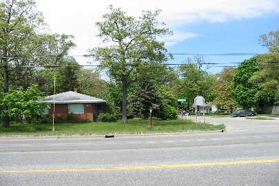
2140 E Apple Ave
Muskegon-Norton Shores, MI
MUSKEGON CHARTER TOWNSHIP SEC 22 T10N R16W SHADY PARK ANNEX LOTS 93 & 94
10-750-000-0093-00
MUSKEGON
Commercialacreage
Michigan
C1
93-94
B and X Area of moderate flood hazard, usually the area between the limits of the 100-year and 500-year floods.
0.38 AC
2025
Eastern Muskegon County
2026
West Michigan
001902
NEARBY LISTINGS FOR SALE OR LEASE
DEMOGRAPHICS near 2140 E Apple Ave
1 mile
3 mile
5 mile
2025 Total Population
8,372
43,090
92,750
2030 Population
8,379
43,364
93,516
Pop Growth 2025-2030
+ 0.08%
+ 0.64%
+ 0.83%
Average Age
41
39
40
2025 Total Households
3,869
16,034
36,158
HH Growth 2025-2030
+ 0.18%
+ 0.80%
+ 0.90%
Median Household Inc
$41,969
$45,175
$50,528
Avg Household Size
2.10
2.40
2.40
2025 Avg HH Vehicles
1.00
1.00
2.00
Median Home Value
$151,033
$119,945
$153,657
Median Year Built
1971
1959
1961
Nearby Places
Map Layers
Map Styles
 Street
 Aerial
Layers
 Traffic
 Biking
Places
Listings with unknown addresses are not visible on the map
- Restaurants
- Banks
- Shops
- Fitness
- Groceries
Nearby Properties
Address
Land Use
TOTAL SIZE
Lot Size
Zoning
Address
Land Use
TOTAL SIZE
Lot Size
Zoning
490,693 SF
22.70 AC
Address
Land Use
TOTAL SIZE
Lot Size
Zoning
82,643 SF
5.20 AC
MC
Address
Land Use
TOTAL SIZE
Lot Size
Zoning
129,264 SF
R
Address
Land Use
TOTAL SIZE
Lot Size
Zoning
446,688 SF
29.50 AC
RM-2
Address
Land Use
TOTAL SIZE
Lot Size
Zoning
892,516 SF
57.88 AC
I
Address
Land Use
TOTAL SIZE
Lot Size
Zoning
116,657 SF
1.60 AC
FBC-UR
Address
Land Use
TOTAL SIZE
Lot Size
Zoning
223,802 SF
22.02 AC
SC-1
Address
Land Use
TOTAL SIZE
Lot Size
Zoning
271,435 SF
13.80 AC
I-2
Address
Land Use
TOTAL SIZE
Lot Size
Zoning
Address
Land Use
TOTAL SIZE
Lot Size
Zoning
19,171 SF
6.55 AC
MC
Address
Land Use
TOTAL SIZE
Lot Size
Zoning
85,577 SF
8.72 AC
PUD
Address
Land Use
TOTAL SIZE
Lot Size
Zoning
163,658 SF
14.70 AC
RM-1
Address
Land Use
TOTAL SIZE
Lot Size
Zoning
71,329 SF
I-2
Address
Land Use
TOTAL SIZE
Lot Size
Zoning
2,044 SF
4.10 AC
R
Address
Land Use
TOTAL SIZE
Lot Size
Zoning
82,895 SF
13.09 AC
SC-1
Address
Land Use
TOTAL SIZE
Lot Size
Zoning
84,806 SF
Address
Land Use
TOTAL SIZE
Lot Size
Zoning
180,144 SF
3.29 AC
RM-1
Address
Land Use
TOTAL SIZE
Lot Size
Zoning
2,466 SF
95.29 AC
RMH
Address
Land Use
TOTAL SIZE
Lot Size
Zoning
60,658 SF
4.42 AC
RM-2
Address
Land Use
TOTAL SIZE
Lot Size
Zoning
241,589 SF
14.60 AC
I-2
Address
Land Use
TOTAL SIZE
Lot Size
Zoning
155,719 SF
13.82 AC
SC-1
Address
Land Use
TOTAL SIZE
Lot Size
Zoning
42,888 SF
2.10 AC
R
Address
Land Use
TOTAL SIZE
Lot Size
Zoning
121,466 SF
11.65 AC
SC-1
Address
Land Use
TOTAL SIZE
Lot Size
Zoning
179,172 SF
20.72 AC
I-2
Address
Land Use
TOTAL SIZE
Lot Size
Zoning
137,702 SF
14.31 AC
I-2
Address
Land Use
TOTAL SIZE
Lot Size
Zoning
80,572 SF
12.98 AC
I-1
Address
Land Use
TOTAL SIZE
Lot Size
Zoning
118,555 SF
12.11 AC
R3
Address
Land Use
TOTAL SIZE
Lot Size
Zoning
17,461 SF
2.72 AC
MC
Address
Land Use
TOTAL SIZE
Lot Size
Zoning
28,000 SF
4.30 AC
C1
Address
Land Use
TOTAL SIZE
Lot Size
Zoning
162,949 SF
7.36 AC
I-2
The World's #1 Commercial Real Estate Marketplace
Connect with us
© 2026 CoStar Group
The information above has been obtained from sources believed reliable. While we do not doubt its accuracy we have not verified it and make no guarantee, warranty or representation about it. It is your responsibility to independently confirm its accuracy and completeness. Any projections, opinions, assumptions, or estimates used are for example only and do not represent the current or future performance of the property. The value of this transaction to you depends on tax and other factors which should be evaluated by your tax, financial, and legal advisors. You and your advisors should conduct a careful, independent investigation of the property to determine to your satisfaction the suitability of the property for your needs.