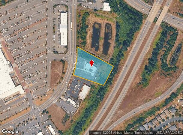
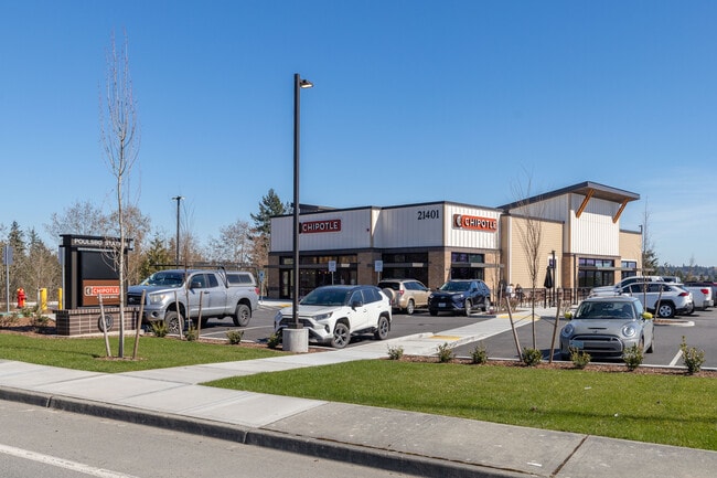
Property Record
21401 Olhava Way Nw, Poulsbo, WA 98370
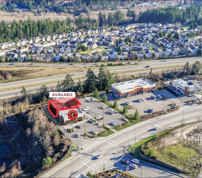
Current Lease Availabilities
NEARBY LISTINGS FOR SALE OR LEASE
Property Detail
21401 Olhava Way Nw
Bremerton-Silverdale, WA
Sp#P-104
102601-4-048-2009
LOT 3-M, CITY OF POULSBO SHORT PLAT NO. P-098 (COLLEGE MARKETPLACE), RECORDED UNDER AUDITORS FILE NO. 200601250111, IN VOLUME 19 OF SHORT PLATS, PAGES 32 - 35, THAT PART OF SECTION 10, TOWNSHIP 26 NORTH, RANGE 1 EAST, W.M, KITSAP COUNTY, WASHINGTON;
Restaurantdrivein
Kitsap
X
Washington
53031C0945C
3-m
2025
1.55 AC
2026
North Kitsap County
090502
Bremerton/Silverdale
DEMOGRAPHICS near 21401 Olhava Way Nw
1 Mile
3 Mile
5 Mile
2024 Total Population
3,904
18,382
31,880
2029 Population
3,941
18,405
31,846
Pop Growth 2024-2029
+ 0.95%
+ 0.13%
(0.11%)
Average Age
41
44
43
2024 Total Households
1,479
7,217
11,808
HH Growth 2024-2029
+ 0.88%
0.00%
(0.17%)
Median Household Inc
$83,266
$93,902
$97,497
Avg Household Size
2.60
2.40
2.50
2024 Avg HH Vehicles
2.00
2.00
2.00
Median Home Value
$521,032
$544,864
$553,371
Median Year Built
1994
1991
1989
Nearby Places
- Restaurants
- Banks
- Shops
- Fitness
- Groceries
PUBLIC TRANSPORTATION
AIRPORT
Seattle Paine Field International
DRIVE
WALK
Distance
Seattle Paine Field International
68 min
27.3 mi
Freight Ports
Port of Seattle
DRIVE
WALK
Distance
Port of Seattle
80 min
37.7 mi
Nearby Properties
Address
Land Use
TOTAL SIZE
Lot Size
Zoning
Address
Land Use
TOTAL SIZE
Lot Size
Zoning
5,198 SF
9.52 AC
RH
Address
Land Use
TOTAL SIZE
Lot Size
Zoning
126,691 SF
6.42 AC
RM
Address
Land Use
TOTAL SIZE
Lot Size
Zoning
140,624 SF
8.46 AC
RH
Address
Land Use
TOTAL SIZE
Lot Size
Zoning
132,992 SF
6.67 AC
RH
Address
Land Use
TOTAL SIZE
Lot Size
Zoning
203,311 SF
20.20 AC
C-4
Address
Land Use
TOTAL SIZE
Lot Size
Zoning
4.06 AC
RM
Address
Land Use
TOTAL SIZE
Lot Size
Zoning
61,458 SF
6.54 AC
RH
Address
Land Use
TOTAL SIZE
Lot Size
Zoning
48,000 SF
0.54 AC
WATER
Address
Land Use
TOTAL SIZE
Lot Size
Zoning
124,970 SF
9.06 AC
C-3
Address
Land Use
TOTAL SIZE
Lot Size
Zoning
94,292 SF
9.34 AC
RL
Address
Land Use
TOTAL SIZE
Lot Size
Zoning
82,081 SF
5.57 AC
RH
Address
Land Use
TOTAL SIZE
Lot Size
Zoning
69,264 SF
4.90 AC
C-1
Address
Land Use
TOTAL SIZE
Lot Size
Zoning
83,314 SF
6.66 AC
BP
Address
Land Use
TOTAL SIZE
Lot Size
Zoning
1,680 SF
14.25 AC
RH
Address
Land Use
TOTAL SIZE
Lot Size
Zoning
70,762 SF
5.90 AC
RH
Address
Land Use
TOTAL SIZE
Lot Size
Zoning
16,358 SF
0.70 AC
C-1
Address
Land Use
TOTAL SIZE
Lot Size
Zoning
103,919 SF
9.02 AC
LI
Address
Land Use
TOTAL SIZE
Lot Size
Zoning
51,096 SF
2.37 AC
C-4
Address
Land Use
TOTAL SIZE
Lot Size
Zoning
98,525 SF
11.40 AC
C-4
Address
Land Use
TOTAL SIZE
Lot Size
Zoning
70,570 SF
6.93 AC
C-3
Address
Land Use
TOTAL SIZE
Lot Size
Zoning
41,492 SF
3.44 AC
RH
Address
Land Use
TOTAL SIZE
Lot Size
Zoning
53,132 SF
2.78 AC
TTEC
Address
Land Use
TOTAL SIZE
Lot Size
Zoning
60,790 SF
5.64 AC
C-3
Address
Land Use
TOTAL SIZE
Lot Size
Zoning
61,185 SF
4.88 AC
C-3
Address
Land Use
TOTAL SIZE
Lot Size
Zoning
35,080 SF
2.99 AC
RH
Address
Land Use
TOTAL SIZE
Lot Size
Zoning
39,474 SF
2.98 AC
RH
Address
Land Use
TOTAL SIZE
Lot Size
Zoning
37,036 SF
2.83 AC
BP
Address
Land Use
TOTAL SIZE
Lot Size
Zoning
41,936 SF
4.03 AC
C-4
Address
Land Use
TOTAL SIZE
Lot Size
Zoning
5.31 AC
LI
Address
Land Use
TOTAL SIZE
Lot Size
Zoning
21,468 SF
0.88 AC
WATER
The World's #1 Commercial Real Estate Marketplace
Connect with us
© 2025 CoStar Group
The information above has been obtained from sources believed reliable. While we do not doubt its accuracy we have not verified it and make no guarantee, warranty or representation about it. It is your responsibility to independently confirm its accuracy and completeness. Any projections, opinions, assumptions, or estimates used are for example only and do not represent the current or future performance of the property. The value of this transaction to you depends on tax and other factors which should be evaluated by your tax, financial, and legal advisors. You and your advisors should conduct a careful, independent investigation of the property to determine to your satisfaction the suitability of the property for your needs.