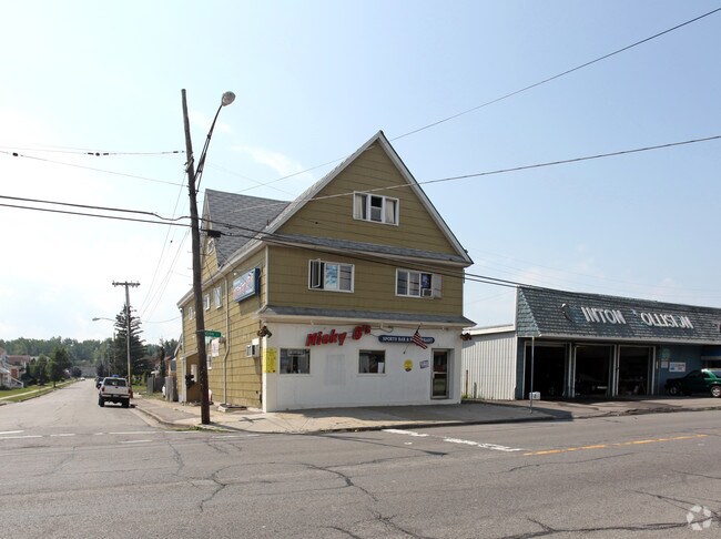
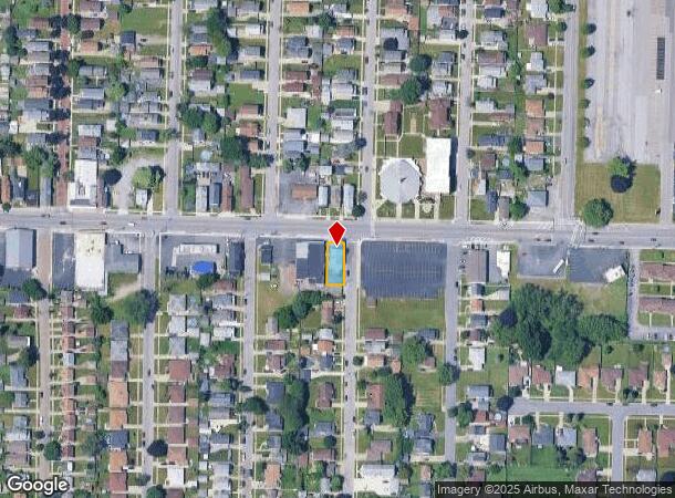
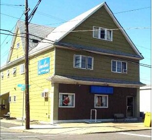
Property Record
2141 Clinton St, Buffalo, NY 14206

NEARBY LISTINGS FOR SALE OR LEASE
Property Detail
2141 Clinton St
Buffalo-Cheektowaga-Niagara Falls, NY
Buffalo Creek Reservation
146800-123-350-0003-005-000
MC-1186 BLK-B SL-7 CLINTON GARDENS S/D 46.02 X 109.35
Bartavern
Erie
X
New York
36029C0331H
5.000
2025
0.12 AC
2024
South
011300
Buffalo/Niagara Falls
4,960 SF
DEMOGRAPHICS near 2141 Clinton St
1 Mile
3 Mile
5 Mile
2024 Total Population
11,239
107,379
285,491
2029 Population
10,943
104,783
280,587
Pop Growth 2024-2029
(2.63%)
(2.42%)
(1.72%)
Average Age
41
40
40
2024 Total Households
5,050
46,469
125,181
HH Growth 2024-2029
(2.77%)
(2.40%)
(1.65%)
Median Household Inc
$52,012
$48,912
$48,077
Avg Household Size
2.20
2.20
2.20
2024 Avg HH Vehicles
1.00
1.00
1.00
Median Home Value
$120,112
$129,130
$145,341
Median Year Built
1949
1949
1950
Nearby Places
- Restaurants
- Banks
- Shops
- Fitness
- Groceries
PUBLIC TRANSPORTATION
COMMUTER RAIL
DRIVE
WALK
Distance
9 min
4.6 mi
DRIVE
WALK
Distance
11 min
5.6 mi
AIRPORT
Buffalo Niagara International
DRIVE
WALK
Distance
Buffalo Niagara International
17 min
8.9 mi
Niagara Falls International
DRIVE
WALK
Distance
Niagara Falls International
37 min
24.5 mi
Nearby Properties
Address
Land Use
TOTAL SIZE
Lot Size
Zoning
Address
Land Use
TOTAL SIZE
Lot Size
Zoning
1,053,391 SF
88.26 AC
D-IL
Address
Land Use
TOTAL SIZE
Lot Size
Zoning
425,796 SF
7.10 AC
D-M
Address
Land Use
TOTAL SIZE
Lot Size
Zoning
611,620 SF
2.20 AC
N-1S
Address
Land Use
TOTAL SIZE
Lot Size
Zoning
420,205 SF
34.42 AC
05
Address
Land Use
TOTAL SIZE
Lot Size
Zoning
31,608 SF
4.36 AC
05C
Address
Land Use
TOTAL SIZE
Lot Size
Zoning
94,165 SF
24.34 AC
05C
Address
Land Use
TOTAL SIZE
Lot Size
Zoning
Address
Land Use
TOTAL SIZE
Lot Size
Zoning
1,322,238 SF
5.81 AC
N-1S
Address
Land Use
TOTAL SIZE
Lot Size
Zoning
7,200 SF
20.20 AC
03RA
Address
Land Use
TOTAL SIZE
Lot Size
Zoning
362,095 SF
25.40 AC
D-IL
Address
Land Use
TOTAL SIZE
Lot Size
Zoning
7,242 SF
18 AC
03RA
Address
Land Use
TOTAL SIZE
Lot Size
Zoning
35,000 SF
30.13 AC
Address
Land Use
TOTAL SIZE
Lot Size
Zoning
972 SF
194.01 AC
D-OG
Address
Land Use
TOTAL SIZE
Lot Size
Zoning
6,720 SF
11.10 AC
03RA
Address
Land Use
TOTAL SIZE
Lot Size
Zoning
87,289 SF
11.55 AC
05C
Address
Land Use
TOTAL SIZE
Lot Size
Zoning
5,304 SF
17.90 AC
03RA
Address
Land Use
TOTAL SIZE
Lot Size
Zoning
92,350 SF
9.20 AC
05C
Address
Land Use
TOTAL SIZE
Lot Size
Zoning
70,480 SF
4.07 AC
05C
Address
Land Use
TOTAL SIZE
Lot Size
Zoning
104,881 SF
24.43 AC
12
Address
Land Use
TOTAL SIZE
Lot Size
Zoning
2,600 SF
14.80 AC
D-IL
Address
Land Use
TOTAL SIZE
Lot Size
Zoning
17,920 SF
9 AC
03RA
Address
Land Use
TOTAL SIZE
Lot Size
Zoning
Address
Land Use
TOTAL SIZE
Lot Size
Zoning
119,168 SF
9.33 AC
05C
Address
Land Use
TOTAL SIZE
Lot Size
Zoning
42,396 SF
6.48 AC
Address
Land Use
TOTAL SIZE
Lot Size
Zoning
205,680 SF
37.40 AC
11
Address
Land Use
TOTAL SIZE
Lot Size
Zoning
119,412 SF
12.70 AC
05C
Address
Land Use
TOTAL SIZE
Lot Size
Zoning
123,147 SF
7.03 AC
CF
Address
Land Use
TOTAL SIZE
Lot Size
Zoning
85,787 SF
2.90 AC
Address
Land Use
TOTAL SIZE
Lot Size
Zoning
7,200 SF
20 AC
03RA
Address
Land Use
TOTAL SIZE
Lot Size
Zoning
429,787 SF
17.31 AC
05C
The World's #1 Commercial Real Estate Marketplace
Connect with us
© 2025 CoStar Group
The information above has been obtained from sources believed reliable. While we do not doubt its accuracy we have not verified it and make no guarantee, warranty or representation about it. It is your responsibility to independently confirm its accuracy and completeness. Any projections, opinions, assumptions, or estimates used are for example only and do not represent the current or future performance of the property. The value of this transaction to you depends on tax and other factors which should be evaluated by your tax, financial, and legal advisors. You and your advisors should conduct a careful, independent investigation of the property to determine to your satisfaction the suitability of the property for your needs.