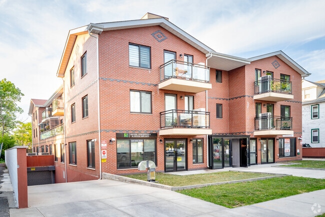
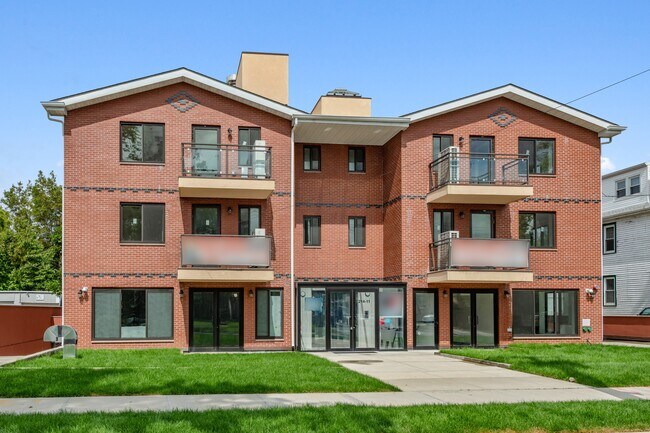
Property Record
21411 35Th Ave, Bayside, NY 11361

NEARBY LISTINGS FOR SALE OR LEASE
Property Detail
21411 35Th Ave
New York-Jersey City-White Plains, NY-NJ
Queens
06119-1024
New York
Condominium
1051
2024
0.45 AC
2025
Bayside
109700
Long Island (New York)
821 SF
DEMOGRAPHICS near 21411 35Th Ave
1 mile
3 mile
5 mile
2024 Total Population
38,454
350,722
934,966
2029 Population
36,038
330,822
879,082
Pop Growth 2024-2029
(6.28%)
(5.67%)
(5.98%)
Average Age
46
45
43
2024 Total Households
15,155
128,024
320,734
HH Growth 2024-2029
(6.55%)
(6.00%)
(6.19%)
Median Household Inc
$87,843
$75,870
$76,651
Avg Household Size
2.50
2.60
2.80
2024 Avg HH Vehicles
1.00
1.00
1.00
Median Home Value
$772,990
$746,417
$715,804
Median Year Built
1958
1956
1955
Nearby Places
Map Layers
Map Styles
 Street
 Aerial
Transit
 Traffic
 Biking
Places
Listings with unknown addresses are not visible on the map
- Restaurants
- Banks
- Shops
- Fitness
- Groceries
PUBLIC TRANSPORTATION
TRANSIT/SUBWAY
Bayside Station (Port Washington Branch - Long Island Rail Road)
Drive
Walk
Distance
Bayside Station (Port Washington Branch - Long Island Rail Road)
2 min
14 min
0.7 mi
COMMUTER RAIL
Bayside Station (Port Washington Branch - Long Island Rail Road)
Drive
Walk
Distance
Bayside Station (Port Washington Branch - Long Island Rail Road)
2 min
11 min
0.5 mi
Auburndale Station (Port Washington Branch - Long Island Rail Road)
Drive
Walk
Distance
Auburndale Station (Port Washington Branch - Long Island Rail Road)
4 min
1.2 mi
AIRPORT
LaGuardia
Drive
Walk
Distance
LaGuardia
16 min
6.4 mi
John F Kennedy International
Drive
Walk
Distance
John F Kennedy International
20 min
12.7 mi
Westchester County
Drive
Walk
Distance
Westchester County
42 min
27.7 mi
Freight Ports
NY - Red Hook Container Terminal
Drive
Walk
Distance
NY - Red Hook Container Terminal
28 min
17.4 mi
SALE & LEASE HISTORY
LISTING DATE
SALE/LEASE

Sep 11, 2020
For Sale
May 12, 2021
For Sale
Mar 05, 2020
For Sale
Mar 03, 2023
For Lease
Jul 07, 2021
For Sale
Nearby Properties
Address
Land Use
TOTAL SIZE
Lot Size
Zoning
Address
Land Use
TOTAL SIZE
Lot Size
Zoning
2,697,663 SF
3.46 AC
C5-3
Address
Land Use
TOTAL SIZE
Lot Size
Zoning
1,666,696 SF
1.87 AC
C52.5
Address
Land Use
TOTAL SIZE
Lot Size
Zoning
7,975 SF
133 AC
PARK
Address
Land Use
TOTAL SIZE
Lot Size
Zoning
878,386 SF
20.55 AC
R4
Address
Land Use
TOTAL SIZE
Lot Size
Zoning
800 SF
104.61 AC
PARK
Address
Land Use
TOTAL SIZE
Lot Size
Zoning
703,265 SF
83.45 AC
R4
Address
Land Use
TOTAL SIZE
Lot Size
Zoning
13,500 SF
104 AC
PARK
Address
Land Use
TOTAL SIZE
Lot Size
Zoning
421,996 SF
136.05 AC
R3-1
Address
Land Use
TOTAL SIZE
Lot Size
Zoning
554,300 SF
20.72 AC
R3-2
Address
Land Use
TOTAL SIZE
Lot Size
Zoning
554,300 SF
20.72 AC
R3-2
Address
Land Use
TOTAL SIZE
Lot Size
Zoning
4,050 SF
113.40 AC
PARK
Address
Land Use
TOTAL SIZE
Lot Size
Zoning
947 SF
101.82 AC
PARK
Address
Land Use
TOTAL SIZE
Lot Size
Zoning
4,800 SF
80.10 AC
PARK
Address
Land Use
TOTAL SIZE
Lot Size
Zoning
1,186,778 SF
31.45 AC
R4
Address
Land Use
TOTAL SIZE
Lot Size
Zoning
202,459 SF
82.16 AC
R3-2
Address
Land Use
TOTAL SIZE
Lot Size
Zoning
448,500 SF
22.59 AC
R3-2
Address
Land Use
TOTAL SIZE
Lot Size
Zoning
644,836 SF
14.26 AC
R5
Address
Land Use
TOTAL SIZE
Lot Size
Zoning
644,836 SF
14.26 AC
R5
Address
Land Use
TOTAL SIZE
Lot Size
Zoning
644,836 SF
14.26 AC
R5
Address
Land Use
TOTAL SIZE
Lot Size
Zoning
644,836 SF
14.26 AC
R5
Address
Land Use
TOTAL SIZE
Lot Size
Zoning
644,836 SF
14.26 AC
R5
Address
Land Use
TOTAL SIZE
Lot Size
Zoning
644,836 SF
14.26 AC
R5
Address
Land Use
TOTAL SIZE
Lot Size
Zoning
644,836 SF
14.26 AC
R5
Address
Land Use
TOTAL SIZE
Lot Size
Zoning
644,836 SF
14.26 AC
R5
Address
Land Use
TOTAL SIZE
Lot Size
Zoning
644,836 SF
14.26 AC
R5
Address
Land Use
TOTAL SIZE
Lot Size
Zoning
644,836 SF
14.26 AC
R5
Address
Land Use
TOTAL SIZE
Lot Size
Zoning
644,836 SF
14.26 AC
R5
Address
Land Use
TOTAL SIZE
Lot Size
Zoning
644,836 SF
14.26 AC
R5
Address
Land Use
TOTAL SIZE
Lot Size
Zoning
644,836 SF
14.26 AC
R5
Address
Land Use
TOTAL SIZE
Lot Size
Zoning
644,836 SF
14.26 AC
R5
The World's #1 Commercial Real Estate Marketplace
Connect with us
© 2026 CoStar Group
The information above has been obtained from sources believed reliable. While we do not doubt its accuracy we have not verified it and make no guarantee, warranty or representation about it. It is your responsibility to independently confirm its accuracy and completeness. Any projections, opinions, assumptions, or estimates used are for example only and do not represent the current or future performance of the property. The value of this transaction to you depends on tax and other factors which should be evaluated by your tax, financial, and legal advisors. You and your advisors should conduct a careful, independent investigation of the property to determine to your satisfaction the suitability of the property for your needs.